

A drone captured these shocking photos of inequality in Mexico’s biggest city
Johnny Miller/Thomson Reuters Foundation
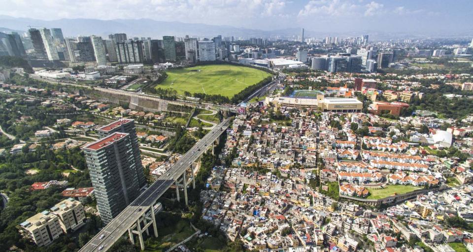
Santa Fe, Mexico City, Mexico.
Greater Mexico City is home to over 21 million people, making it the biggest metropolitan area in the western hemisphere and the largest Spanish-speaking city in the world.
But the region is deeply divided between the haves and have-nots.
A mere four multimillionaires account for 9% of the country’s GDP, according to a 2015 report by international aid organization Oxfam. For comparison, nearly half of the population lives under the poverty line. The wealth gap has widened in recent years.
In 2016, photographer Johnny Miller set out to capture Mexico City’s inequality from above. The images, taken by a consumer drone, show the contrast as rarely seen before.
Miller shared his work from the Thompson Reuters Foundation series, Slumscapes, with us. You can check out more on his project website, Unequal Scenes.
Mexico City is a bustling metropolis that sits atop a dried lakebed. The region once served as the heartland of the Aztec Empire, until the Spaniards conquered it in the 16th century.

There are reminders of its ancient history in street names and festivals. But in many ways, Mexico City is not unlike many US cities, with its triple-decker highways and skyscrapers.

One thing sets it apart. Mexico’s capital city is one of the most unequal cities in the world.

Economic and political power are concentrated among the extremely rich. In fact, the wealthiest 1% of the Mexican population earns 21% of the nation’s total income.

Source: Oxfam México
Carlos Slim Helu, the world’s fourth richest person, calls Mexico City home. His telecommunications company, Telcel, controlled 70% of Mexico’s wireless market in 2014.

Source: Forbes
Mexico City’s upper class lives in new developments, gated communities, and sprawling, leafy neighborhoods located just outside the downtown area.

Meanwhile, those living in poverty reside in ramshackle dwellings. Their neighborhoods pack them in closely, like sardines in a can.

Mexico City’s most blighted area, Ciudad Nezahualcoyotl (or Neza, for short), is inhabited by over one million people spread across 24 square miles. It appears to go on forever.

Miller says it’s disheartening to walk among the laborers who built the glittering skyscrapers seen in the distance. They will likely never be able to live there.

Here, a low-income neighborhood sits adjacent to private school grounds. “I think it’s very clear, looking at that dirt soccer pitch, which side is the more affluent side,” Miller says.

Miller, who currently lives in Cape Town, South Africa, flew to Mexico City on assignment with the Thompson Reuters Foundation. He knew the city lent itself to aerial photography.

Google Maps and a fellow photographer, who was more familiar with the area, helped Miller identify safe places to launch and land his DJI Inspire One drone. It costs about $3,000.

The drone communicates with an app on his cell phone, so Miller can see what the drone sees. A typical flight lasts 10 minutes, and he snaps 10 to 20 photos at each site.

The results are dizzying.

You can check out more of Miller’s work on his project website, Unequal Scenes.
The post A drone captured these shocking photos of inequality in Mexico’s biggest city appeared first on Business Insider.
