Tropical storm warning issued for South Texas and Mexico as first storm takes shape
A tropical storm warning is now in effect for parts of South Texas and northeastern Mexico as the first tropical threat of the year closes in on the areas.
It’s not the only area of tropical concern looming large this week as a predicted hyperactive hurricane season kicks into gear.
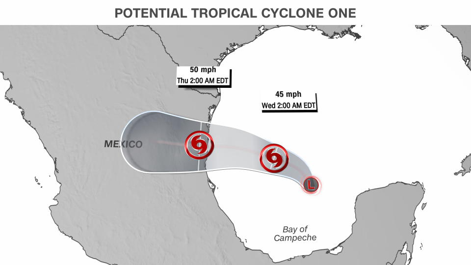
The system threatening the southwestern Gulf Coast has been designated Potential Tropical Cyclone One by the National Hurricane Center as it tries to get organized in the Gulf of Mexico. It will unload torrential rainfall and considerably ramp up the flood threat, not just in the US, but also in parts of Mexico and Central America.
As the name suggests, Potential Tropical Cyclone One isn’t quite a tropical storm yet, but is expected to become one and poses a threat to the areas in the tropical storm warning over the next 48 hours.

The system had 40 mph winds Tuesday morning – strong enough that if it does develop a coherent circulation, it would be named Tropical Storm Alberto. It’s forecast to by late Tuesday or Wednesday before approaching the northern coast of Mexico on Wednesday night.
The system’s strength will be limited by its short time over water, but it’s main threat of significant rain and flooding will not: multiple days of gushing rainfall for parts of Central America, southern Mexico and the US western Gulf Coast.
Heavy rain was already ongoing Monday in parts of Mexico, Guatemala, Belize, El Salvador and Honduras as the gyre churned. Double-digit rainfall totals are possible in these areas by Thursday. Rain is needed desperately in parts of Mexico and Central America that are bone-dry after weeks of unrelenting heat. But day after day of heavy rain will quickly overwhelm parched soils unable to absorb water as fast as it falls, resulting in dangerous flooding.
Deep tropical moisture was also fueling storms as far north as the US’s western Gulf Coast. Double-digit rainfall totals are likely in portions of coastal and southern Texas by the weekend, while other portions of the Gulf Coast could pick up several inches through midweek.
A level 3 of 4 risk of flooding rainfall is in place for the Texas coast Tuesday and much of South Texas on Wednesday.
By Wednesday, the air over the Gulf Coast will be loaded up with “incredible amounts of moisture” which could “easily” produce flash flooding, the Weather Prediction Center warned Monday.
Heavy rain isn’t the most welcome sight along some parts of the US Gulf Coast. June has been drier after a drenching spring, but the soil and area rivers are still holding on to plenty of water in eastern Texas and western Louisiana.
Another tropical threat could take shape
Another tropical threat is stirring in the Atlantic as development gets underway in the Gulf of Mexico.
An area of showers and thunderstorms a few hundred miles east of the Bahamas could be the starting point for a potential tropical system later this week. Right now, the National Hurricane Center gives it a low chance of developing into a tropical system.
Multiple atmospheric factors must align for the area of stormy weather to get its act together, but the opportunity for development exists over the next few days as it slowly pushes westward.
If something tropical does develop, it could approach the southeastern US by Thursday or Friday and be steered south of the heat dome roasting areas farther north. It’s unclear exactly which areas could be impacted, but anywhere from Florida to the Carolinas should keep a close eye on the forecast as it comes into focus in the coming days.
Drenching rain could soak parts of the Southeast coast and rough seas are possible from the Bahamas to the mid-Atlantic coasts regardless of development.
For more CNN news and newsletters create an account at CNN.com

