
Midwest, Northeast to experience hottest weather in years as temps near 100 F


Temperatures will build to their highest marks in years across the Midwest and Northeast and stay at sizzling levels for days as Mother Nature cranks up the heat ahead of astronomical summer, which begins Thursday, June 20, at 4:50 p.m. EDT.
AccuWeather's long-range team has been sounding the alarm for more than a week on building heat in the East during the third week of June that would put millions at the mercy of a prolonged stretch of 90-degree Fahrenheit temperatures. The longevity of the intense heat will put additional strain on residents and electrical infrastructure.
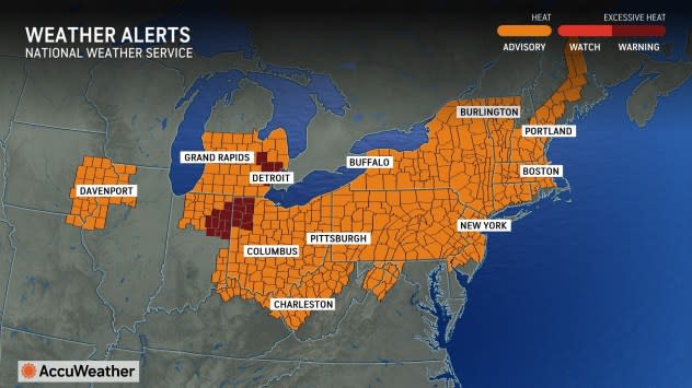
For many in the Midwest and Northeast, this week will constitute the first official heat wave of the season, which, in this part of the country, is defined as three or more consecutive days of at least 90-degree temperatures. Heat alerts have been issued for more than a dozen states, stretching from Iowa and Illinois to Maine, as the summer swelter takes shape.
 |
"A large, sprawling area of high pressure will help to pump hot air into the East, and this pattern is expected to sustain itself into the upcoming weekend," AccuWeather Senior Meteorologist Tyler Roys said. "The peak of the heat wave for most of this zone is expected to occur around or just after the start of astronomical summer."
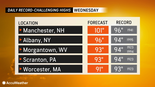
High temperatures will be in the 90s F for a week or more in major metro areas such as Chicago, Detroit, Pittsburgh, Washington, D.C., Baltimore and Philadelphia. Daily record highs, with a couple dating back to the 1920s and 1930s, can be challenged for one or more days in each city amid the pattern. The exclusive AccuWeather HeatWave Counter and Severity Index™, which measures heat waves by duration and intensity, quantifies the heat wave in New York City as "moderate," Chicago as "strong" and Philadelphia as "severe."
 |
Temperatures are projected to climb 10-15 degrees above historical averages for the latter half of June, which are steadily climbing into or through the 80s for most locations. Historical average high temperatures do not reach their peak until July across this part of the country.
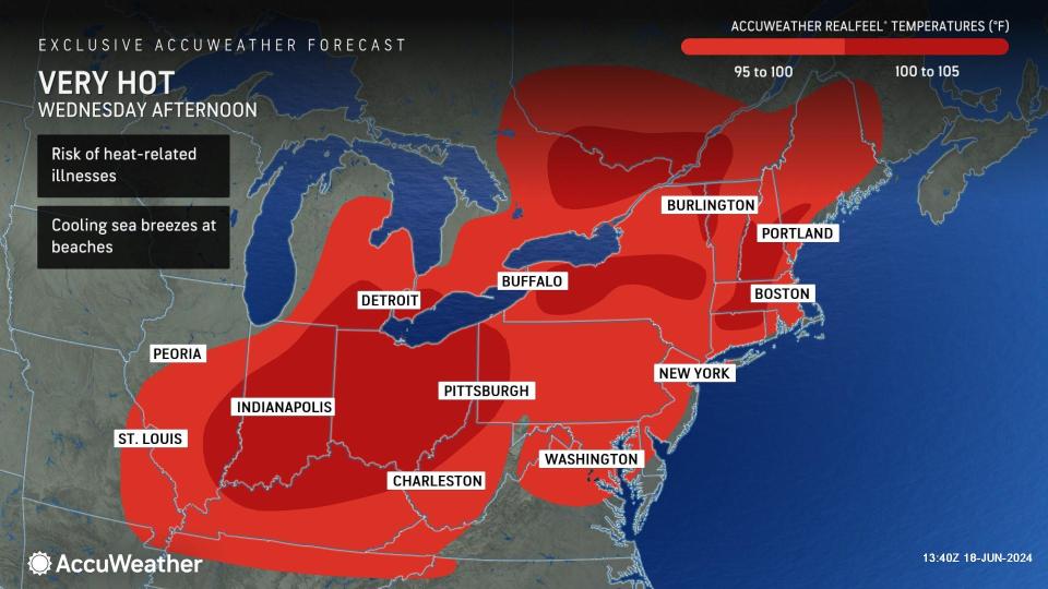
Many locations will be within a few degrees of triple digits, with a few spots predicted to reach 100 degrees.
 |
If the mercury in Manchester, New Hampshire, surpasses the 100-degree mark as predicted, it will be the city's hottest day since July 22, 2011.
During the afternoon hours, AccuWeather RealFeel® Temperatures can approach or top triple digits as humidity and sunshine add a few extra degrees to how it feels outside.
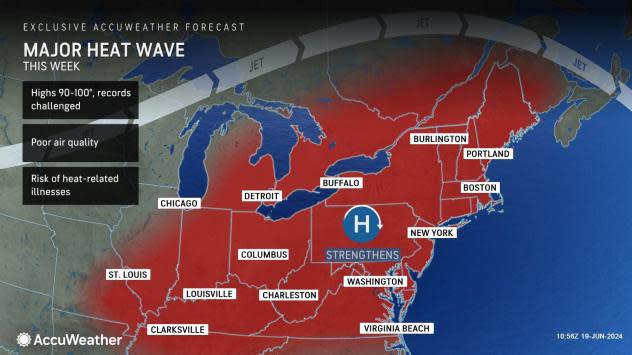
Although high heat is not uncommon in any of these areas during the summer months, the fact that this heat wave is projected to be particularly long and intense and occurring so early in the season is particularly notable.
There will be little relief at night as low temperatures remain elevated across much of the region, and humidity levels will remain high and even climb during the overnight hours, according to Roys. The limited relief during the nighttime hours will greatly decrease the body's ability to properly cool itself for individuals in buildings without air conditioning.
The near-record heat could pose an even higher risk to the public in southeastern Canada, where air conditioning is not as prevalent.
"Southern Quebec will experience temperatures in the low to mid-90s F (32-36 C). Adding to the challenge, high humidity - uncommon in this part of Canada," Roys said.
 |
The potential for heat-related illnesses is highest during the latter part of heat waves and even in the days following, as the stress of consecutive days of hot weather takes time to build up in the body, according to AccuWeather Senior Director of Forecasting Operations Dan DePodwin.
Residents and visitors throughout the Midwest and Northeast are urged to take every precaution possible to limit the risk of heat-related illnesses. Some ways to stay safe in the heat include limiting outdoor activity, staying in air-conditioned buildings, drinking plenty of water or electrolyte beverages even when you are not thirsty, and checking on more vulnerable populations.
"Due to the stagnant weather pattern this week, air quality is anticipated to deteriorate significantly, particularly along the Interstate 95 corridor from Washington, D.C., to Boston. Metropolitan areas such as Cleveland, Cincinnati, Indianapolis and Montreal, Quebec, are also at risk," Roys said.
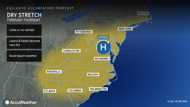
The hot pattern, while not without risks, will promote great weather for those with plans to head to the beach. While water temperatures are still fairly chilly, generally in the 60s from Ocean City, Maryland, to Cape Cod, Massachusetts, plenty of sunshine, light winds, and dry conditions will be ideal for those looking to cool down close to the water.
The light winds will limit the risk of more frequent or stronger-than-usual rip currents, as well as rough seas.
 |
Dry weather is expected to hold through at least Thursday along the coast, perhaps into the weekend for the mid-Atlantic beaches.
Farther inland, there will be a daily eruption of showers and thunderstorms along the western and northern rim of the heat, generally across the eastern Great Lakes and central and northern Appalachians. Some of these storms can pop up with little notice and produce heavy rainfall and strong wind gusts. Dangerous lightning strikes will accompany a storm of any strength.
By the end of the week, showers and thunderstorms may sink farther to the south, into more of New England, as a front crosses southeastern Canada with relief from heat and humidity. In the Northeast, however, there may be no appreciable relief from the sweltering conditions until next week.
Want next-level safety, ad-free? Unlock advanced, hyperlocal severe weather alerts when you subscribe to Premium+ on the AccuWeather app. AccuWeather Alerts™ are prompted by our expert meteorologists who monitor and analyze dangerous weather risks 24/7 to keep you and your family safer.