
1st significant, widespread lake-effect snow event of the season to threaten travel

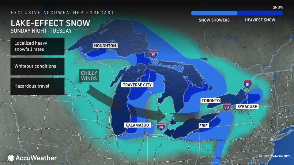
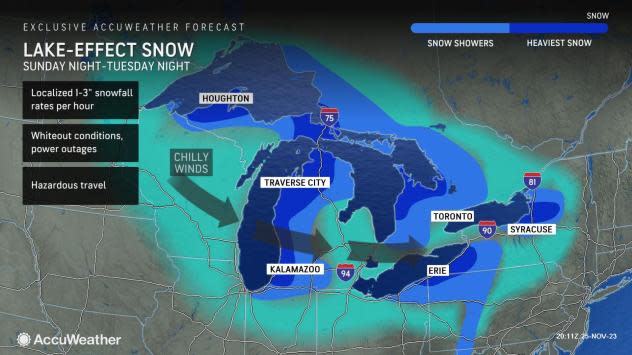

There have been a few close calls with outbreaks of lake-effect snow so far this season, but it appears the one poised to unfold Sunday and into the new week is unavoidable. And, AccuWeather meteorologists warn this first major snow event of the season could be highly disruptive for travel from the Upper Midwest to the interior Northeast with feet of snow possible for some locations.
"Some roads may even close for a time due to the intensity of the lake-effect snow," AccuWeather Storm Warning Meteorologist Jake Sojda said.
 |
The lake-effect snow event will develop by early this week as three storms merge together into one large storm over eastern Ontario and Quebec, Canada. A storm moving northward along the Atlantic coast will link up with a storm heading northeastward over the Central states. Finally, a storm from western Canada will complete the merge.
As that large storm strengthens, winds will increase substantially, and Arctic air will be funneled across the open waters of the Great Lakes, leading to everything from flurries and snow showers to bands of heavy snow and snow squalls. In some cases, the lake effect may act like a thunderstorm in the winter and could produce thunder and lightning, creating a phenomenon known as thundersnow.
One of the key impacts during lake-effect snow is the likelihood of sudden, poor visibility in the heavy snow bands and snow squalls. Combined with gusty winds, power outages are also a concern.
The intense wintry conditions can arise in a matter of seconds for people traveling along at highway speeds, given the dramatic, localized nature of lake-effect snow. Road conditions can change from dry to wet to snow-covered and slippery at distances of a few hundred feet.
"Travel headaches will abound along I-90 from just south of Buffalo, New York, all the way to Cleveland during the first half of the week due to heavy snow coming off the lake," Sojda said.
 |
Some highly prone areas for road closures with the upcoming lake-effect event include Interstate 81 from Syracuse to near Watertown, New York, Interstate 90 in western New York and northeast Ohio and Interstate 94 and Interstate 196 in Michigan.
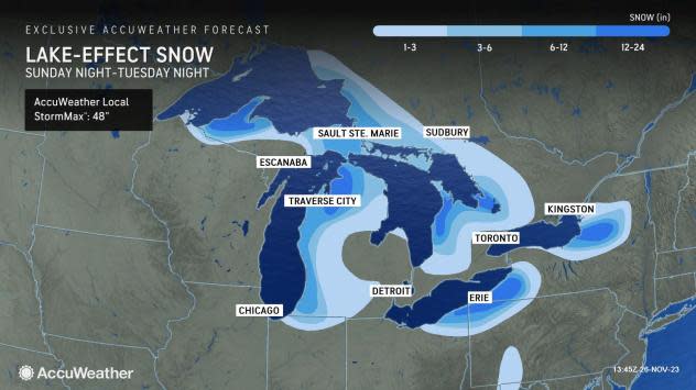
"Snowfall totals are likely to exceed 1 foot, where the bands of snow linger in northern and western Michigan, northeastern Ohio into southwestern New York and off the eastern end of Lake Ontario in upstate New York," Sojda said.
"Some of the most favored snow belts in the Upper Peninsula of Michigan, 'ski-country' south of Buffalo and the Tug Hill Plateau in northern New York are likely to challenge or perhaps even exceed 3 feet of snow, depending on the persistence of the heavy bands," Sojda added.
Several inches of snow are likely to fall on part of northwestern Indiana as well from Sunday night to Monday night.
A disturbance could also enhance the coverage of the snow and bring a couple of heavy bursts in rather uncommon locations for lake effect. Accumulating snow may briefly fall in Pittsburgh and Detroit from later Sunday night to Monday, Sojda said. Outside of this, however, snow is expected to remain confined to the typical lake snow belts.
The lake-effect snow is likely to diminish by Tuesday night in Michigan and Indiana, but it may persist as long as Wednesday and Thursday in areas farther east.
 |
However, as an Alberta clipper storm drops southeastward from western and central Canada, the bands of snow are likely to shift around. As that clipper storm moves along, it could enhance the lake effect in some locations and bring a new round of lake-effect snow bands in its wake later in the week.
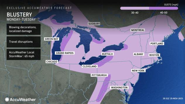
As a result, the cold and blustery pattern this week will be the most persistent of its kind thus far this season and more typical of the heart of the winter season.
The strong winds associated with the Arctic air outbreak and lake effect will create painfully low AccuWeather RealFeel® Temperatures, more typical of the middle of the winter. Frequent wind gusts will range between 30 and 50 mph near the Great Lakes. The AccuWeather Local StormMax™ Wind Gust is 65 mph. At this level, sporadic power outages could occur.
 |
AccuWeather RealFeel® Temperatures will dip to 20 degrees Fahrenheit lower than the actual temperature, which will dip well down into the 20s in some areas and even the teens in the northern tier.
The persistent winds will push lake waters toward the west- and northwest-facing shorelines, where overwash and even freezing spray are likely in some places.
Want next-level safety, ad-free? Unlock advanced, hyperlocal severe weather alerts when you subscribe to Premium+ on the AccuWeather app. AccuWeather Alerts™ are prompted by our expert meteorologists who monitor and analyze dangerous weather risks 24/7 to keep you and your family safer.
