
How AeroTerrascan plans to skyrocket Indonesia’s aviation and aerospace dream
With the ambition to make building communications satellites more affordable, the Bandung-based company takes part in the record-breaking Menembus Langit project
Founder Dian Rusdiana Hakim poses with ATS drones
In late October 2016, the Menembus Langit project launched a rocket consisting of an Ai-X1 drone from a technological research and observation centre belonging to the National Aviation and Aerospace Institute (LAPAN) in Garut, West Java, Indonesia.
On the first day of the launch — which was broadcast live via Twitter — the drone was propelled with the help of a weather balloon and managed to reach 10 kilometres above sea-level.
But a GPS glitch forced the drone to activate its fail-safe scenario: The drone released itself from the weather balloon and performed return-to-home procedure to get back to its launching spot. Bad weather has been reported as the main culprit behind the failure.
On the second day of the launch, despite having experienced issues with its GPS again, the drone had successfully reached 19.3 kilometres above sea-level.
It was eventually awarded the National Museum of Record accolade for being Indonesia’s first stratospheric space shuttle drone to reach such height.

The Ai-X1 drone. Image Credit: Menembus Langit
Also Read: NASA is developing an Alexa-enabled robot for its Mars mission 2020
Menembus Langit project is a result of a collaboration across 18 governmental and private institutions and 95 individuals. The project aims to inspire the rise of Indonesian aviation and aerospace industry, proving the role of collaborative efforts in it.
The drone used in the project was built by AeroTerrascan (ATS), a subsidiary of PT. Aero Terra Indonesia.
On a fine afternoon, e27 paid a visit to the company’s drone factory to talk with ATS founder Dian Rusdiana Hakim. While the company’s head office is located in the downtown area of Bandung, the company chose a village just outside of the city as the location for their factory.
“The idea for Menembus Langit has been around since long ago, but only in 2016 that we managed to make it come true,” Hakim began the story behind the project.
“Before the flight, we visited several universities, meeting with aviation experts to consult the project. That is how we found out that the data that we need for the mission do not exist, because nobody has ever done this before. That’s how we decided to jump into this, certainly by using scientific approach such as aerodynamic calculation, trajectory, and many more,” he explained.
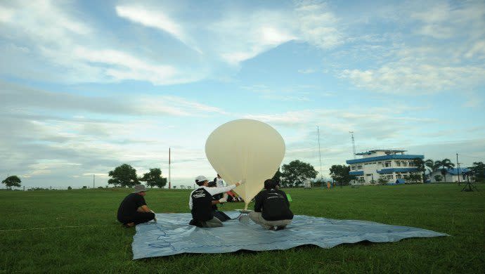
Preparing for flight. Image Credit: Menembus Langit
Also Read: This ex-NASA scientist is using big data to raise yields on China’s small farmlands
Together we fly
From the trial flight in October, the team managed to gather vital atmospheric and aerodynamic data that would benefit preparation of their next launch, which is due to happen in late 2017. Eventually, it will also be used in building much bigger aircraft.
The team also plans to keep the data open for public consumption, so that individuals and research institutes will be able to access it — and if possible, to join the project, Hakim expects.
“These days, you just cannot do anything by yourself. If we look at what happened abroad, even European aviation giants like Airbus turned out to be supported by several small and medium enterprises (SMEs),” he said.
Crowdsourced resources are believed to be the key to the rise of the Indonesian aviation and aerospace industry, which had previously been a monopoly of state-owned PT Dirgantara Indonesia (PTDI).
“In the past, everything was very centralised, [using] top-down [approach]. Everything is already being arranged by the leader. But today is a new era when everything begins from below, from bottom-up. Perhaps we — SMEs or individuals who are able to move Indonesian aerospace industry forward — should be able to back-up the existing institutions,” he explained.
Also Read: Space tempeh: Indonesian high schoolers join forces with NASA to send rice, yeast to ISS
There is hope in the horizon as in 2013, constitutional changes finally allowed LAPAN to conduct aviation technology researches on their own.
“This is why we recently joined in the Indonesian Aeronautics Engineering Centre (IAEC), a hub for aviation industry players … We want to be able to support this industry by helping PTDI. Small enterprises like us might also be involved in setting up national programmes for aviation,” Hakim explained.

Menembus Langit Programme Director Azhar T. Pangesti at the Command Center
Launching to the future
Despite having set national records, this is not the end of the road for Menembus Langit, as the project is set to conduct at least two more sets of trial in 2017.
Hakim says that his goal is for the drone to reach 30 kilometres above ground, and eventually, to fly for up to six months in the air.
In the long run, he hopes that the projects will make building communications satellites more affordable.
“If this turns out to be a success, we can build it for Indonesia,” he said.
Also Read: Singapore’s Infinium Robotics in talks with NASA to build drone software
ATS itself is one of the four subsidiaries of PT Aero Terra Indonesia. Some of its sister companies are AeroGeosurvey (focussing on services such as geo-mapping), Global Inovasi Informasi Indonesia (focussing on drone manufacturing), AeroVisualStudios, and HiberNagen (drones for hobbyists).
ATS was incorporated when Hakim decided to focus more on civilian-based clients, after years of servicing clients in the military and government.
By late 2016, the startup claimed to have sold 500 batches of its Ai-450 drones. Through its clients’ use of the products, it has mapped up to seven million hectares of land in the country.
The startup had also worked for several disaster risk management projects, such as a project with Gadjah Mada University. An ATS drone managed to reach 3,400 metres above-sea-level to create 3D mapping of Mt. Merapi. The mapping enabled scientists to correctly predict the direction of the eruption.
This year, ATS is going to see more product launches and it is planning to start selling its drone to international markets.
“Everything that we created, if it manages to bring impact into people’s lives … Then there is a certain pride in it,” he closed.

View from above. Image Credit: Menembus Langit
—-
The post How AeroTerrascan plans to skyrocket Indonesia’s aviation and aerospace dream appeared first on e27.

