
Atmospheric river to unleash month's worth of rain in Pacific Northwest


It will be a wet and snowy start to December across the Northwest as the region remains the focal point for a series of storms featuring a month's worth of rain and feet of mountain snow.
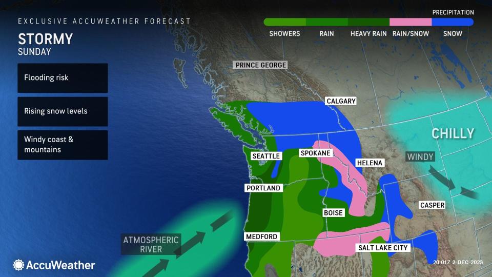
A flow of moisture from the Pacific Ocean, known as an atmospheric river, will send a nearly continuous barrage of storms into the Northwest into the first week of December, increasing the risk of flooding in the lower elevations while snow could clog mountain passes, leading to travel disruptions throughout the region.
The train of storms will continue to spread rain across western Oregon and Washington into northwestern California through much of the new week. Cities across the region including Portland and Eugene, Oregon, and Seattle can record multiple inches of rain through Tuesday. Rainfall totals will be the highest along the coast and in the coastal mountain ranges where upwards of a foot of rain can occur in some areas.
 |
Through this Thursday, the rainfall total in Portland could approach or surpass the historical average rainfall for the entire month of December, which is 5.77 inches.
Repeated rounds of heavy rain can cause travel disruptions across the region, including the Interstate 5 corridor, where ponding on roadways and reduced visibility are likely. Flooding on roadways and in low-lying areas can also occur as a result of heavy rainfall. Individuals are urged to use caution and avoid any flooded areas.
The cold air that was in place as the first push of storms crashed ashore late Friday into Saturday will be replaced with milder conditions as the pattern progresses.
In the wake of multiple feet of snow in passes such as Willamette, Santiam, White and Snoqualmie early in the weekend, snow levels are expected to rise significantly and cause snow to transition to rain early in the week.
The combination of warmer air and rainfall will cause any snow on the ground in the Cascades and Olympics to melt suddenly, adding to the flooding concerns across the region.
"As snow levels rise considerably during the train of storms, there is a high risk of flooding along the small streams and short-run rivers that extend out of the Cascades and the Olympics," said AccuWeather Senior Meteorologist Alex Sosnowski.
 |
Along with the flooding risk, heavy rain falling in the mountains amid rising temperatures could cause the snowpack on steep mountain slopes to become more unstable, increasing the risk of avalanches. Individuals planning to spend time outdoors in the high country of the Northwest are urged to use extreme caution and consider delaying any activities until conditions improve.
Gusty winds along the Pacific coast can accompany the upcoming storms with gusts ranging between 40 and 60 mph. Winds of this magnitude can cause any outdoor furniture or holiday decorations to be tossed around as well as impact travel for high-profile vehicles.
As the ground becomes increasingly saturated, the risk of trees toppling over in wind gusts lower than 40 mph will increase.
Toward the end of the new week, forecasters say that the pattern may change, which could bring an end to the parade of storms and usher in drier conditions across the region.
Want next-level safety, ad-free? Unlock advanced, hyperlocal severe weather alerts when you subscribe to Premium+ on the AccuWeather app. AccuWeather Alerts™ are prompted by our expert meteorologists who monitor and analyze dangerous weather risks 24/7 to keep you and your family safer.
