
Blockbuster coastal storm to make for a tricky morning commute


A potent storm barreling up the East coast into the start of the new week will continue to spread drenching rain and blustery winds as it tracks northward through New England. AccuWeather meteorologists say that the back side of the storm will also usher in squally conditions from the Midwest to the Northeast as chilly air filters southward out of Canada.
The primary factors associated with this storm will be heavy rain and gusty winds, which can result in impacts such as coastal inundation, beach erosion, power outages and difficult travel. The timing of the heaviest rainfall and peak wind gusts will especially prove challenging for the morning commute on Monday in metro areas like New York City, Boston and Providence, Rhode Island.
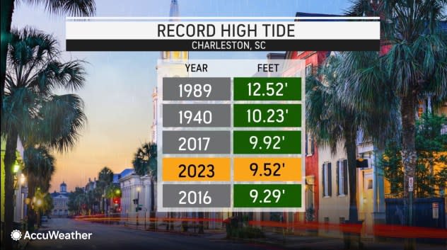
In Charleston, South Carolina, tides surged to their fourth highest level on record at 9.52 feet during the height of the storm this past weekend.
 |
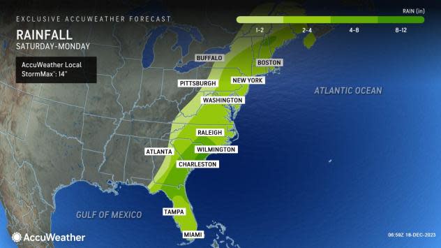
The storm has cut the power for more than 600,000 utility customers in the Northeast alone as of Monday midday, according to poweroutage.us. Coastal flooding has been a legacy of the storm in the Southeast and now small streams and rivers are on the rise in parts of the Northeast as the saturated ground cannot handle any more rain. The storm has unloaded up to 16.32 inches of rain near McClellanville, South Carolina, and wind gusts topping 80 mph have been reported on at least one pier in North Carolina.
Forecasters say that residents from New Jersey to Massachusetts and Maine will face some of their heftiest rainfall totals from this storm into Monday afternoon as it tracks along the coast.
 |
Locations such as Richmond, Virginia, Washington, D.C., Philadelphia and New York City can easily collect anywhere between 2.00 to 3.00 inches into Monday morning. Locally higher amounts can also occur across this zone.
People may need to give themselves a little extra time when commuting, due to flooded roads and poor visibility on Monday, explained AccuWeather Meteorologist Alex DaSilva.
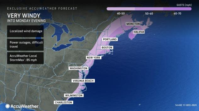
Wind gusts can range from 40-50 mph from areas of eastern Virginia through far eastern Pennsylvania to western Maine as the storm advances northward through Monday evening.
 |
Higher wind gusts from 50-60 mph can occur closer to the coast from Virginia Beach to eastern Maine, while a narrow corridor of coastal winds can ramp up to 60-70 mph during the storm's peak strength across far eastern Long Island, Cape Cod and directly along the coast in Mid Coast and Down East Maine. The AccuWeather Local StormMax™ for wind is 85 mph for this storm.
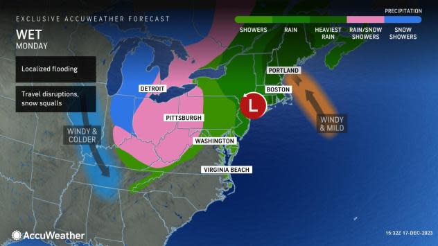
DaSilva added that torrential downpours and very gusty winds could lead to significant travel disruptions along the Northeast coast. There could even be travel restrictions on some bridges for high-profile vehicles due to the high winds.
The New York City Mayor Eric Adams and the New York Emergency Management office issued a travel advisory for the city through Monday. In preparation for the coastal storm, the New York City Emergency Management also activated the Flash Flood Emergency Plan.
The statement from the Office of the Mayor also noted that the New York City Department of Sanitation will be checking and servicing hundreds of catch basins citywide, with equipment ready to assist in tree-related incidents as the storm impacts the region.
 |
Any early holiday travelers across the Northeast and New England should closely monitor weather updates and any additional travel advisories across the region over the upcoming days. Forecasters say that travel delays or cancellations can occur as a result of this developing storm, especially on Monday along the Northeast coast.
Residents in areas that are projected to face gusty winds should secure any outdoor holiday or seasonal decorations ahead of the storm's arrival.
Behind the storm, cooler conditions and even wintry weather will spread across the interior Northeast from Monday to Tuesday. Temperatures across the Northeast are expected to linger near typical December values through the remainder of the week.
A zone of high pressure will take over much of the Ohio and Tennessee valleys to the East Coast after this storm departs, ushering in largely dry conditions from Wednesday to Thursday. Any holiday travelers looking for a window of calmer weather this week could take advantage of the dry stretch expected from Wednesday to Thursday across the eastern United States.
Want next-level safety, ad-free? Unlock advanced, hyperlocal severe weather alerts when you subscribe to Premium+ on the AccuWeather app. AccuWeather Alerts™ are prompted by our expert meteorologists who monitor and analyze dangerous weather risks 24/7 to keep you and your family safer.
