
Rainstorm along US Gulf Coast may snap exceptional drought


Soon after rain from one storm dwindled in parts of the Gulf Coast states, a new storm developed offshore of the Texas coastline. AccuWeather meteorologists say the newest storm will likely tap into tropical moisture and unload much-needed drenching rain in areas from Texas to Georgia during the first part of the new week.
 |
A dip in the jet stream that helped produce a moderate Santa Ana wind event in Southern California from this past Thursday and Friday has pushed across northern Mexico and developed into a new storm somewhere in the western Gulf of Mexico, just offshore of the Texas coast.
There is the potential for copious amounts of tropical moisture to become involved as this storm continues and expands into the middle of the week.
 |
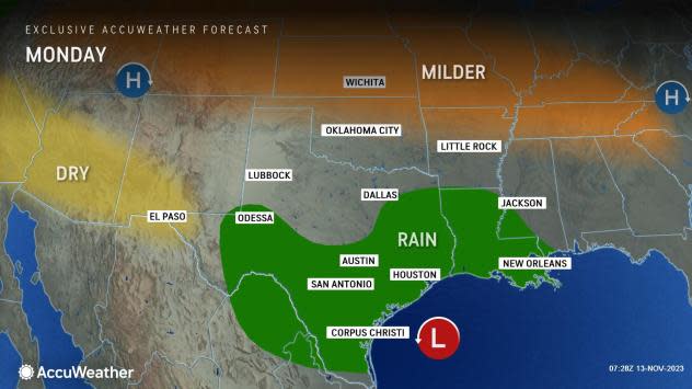
"As the storm crawls northeastward along the stalled front from near the Gulf Coast, a broad zone of 2-4 inches of rain is likely from South Texas to much of Louisiana, central and southern Mississippi, southwestern and central Alabama and the western part of the Florida Peninsula," AccuWeather Senior Meteorologist Brett Anderson said. "Within this zone, pockets of 4-8 inches of rain are likely with an AccuWeather Local StormMax™ of 12 inches by the conclusion of the storm during the middle of the week."
The rain will lead to slick roadways and could lead to disruptions to travel, outdoor plans and projects.
 |
If it were not such close company to the frontal zone from last week, the system might end up being one step away from a tropical rainstorm or tropical depression, AccuWeather Senior Storm Warning Meteorologist Brian Wimer said.
For an official tropical depression to develop, a circulatory wind pattern would be needed around a well-defined storm center with a warm core. Winds within a tropical depression are under 39 mph.
AccuWeather meteorologists will also be keeping an eye on the Caribbean Sea for possible tropical development this week.
Regardless of the classification of the upcoming Gulf Coast storm, rain is tremendously needed in the region. For many weeks, areas in much of Louisiana, southern and central Mississippi and northeastern Texas have been experiencing exceptional drought, which is the worst of four stages of drought, according to the United States Drought Monitor.
 |
In this aerial photo, responders are seen near wreckage in the aftermath of a multi-vehicle pileup on I-55 in Manchac, La., Monday, Oct. 23, 2023. A “super fog” event combining smoke from south Louisiana marsh fires and dense morning fog caused multiple traffic crashes involving scores of cars. (AP Photo/Gerald Herbert) |
The drought has been so bad that wildfires have been a problem in normally swampy areas. Smoke from the fires combined with fog in some cases to lead to super fog. The smoky fog was so dense, down to several feet in localized areas, that deadly chain-reaction crashes have occurred on Louisiana interstate highways in recent weeks.
At the same time, drought has expanded to large areas of the southern Appalachians, Piedmont and Atlantic coast locations and continues in areas farther to the west in Texas.
 |
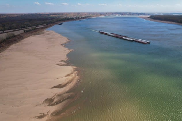
The drought has also been prevalent since the summer over much of the Mississippi River basin and has produced record-low levels in some areas, including at Memphis, Tennessee. The flow of the mighty Mississippi has been reduced so much that salt water has intruded upstream and mingled with the water supply in southern Louisiana.
Hit-or-miss rain events in parts of the Mississippi Watershed recently have allowed river levels to recover up to a few feet, but further dips in levels are likely during the winter.
Since some of the rain from the storm will fall directly on the Delta Region of the Mississippi River, there is likely to be a small bump in water levels, especially if a soaking rain falls on rivers such as the Yazoo and Big Black in Mississippi. The small rise in water levels should also increase stream flow on the lower end of the Mississippi and may help temporarily reverse or slow the encroachment of salt water from the Gulf of Mexico around New Orleans.
 |
A barge moves on the Mississippi River, Wednesday, Nov. 8, 2023, near Cairo, Ill. Parts of the Mississippi River have been at historic lows after drought conditions have persisted this fall. (AP Photo/Joshua A. Bickel) |
Drenching downpours from the rainstorm are not likely to reach everywhere in need across the Southern states. AccuWeather forecasters say there will be a sharp northern edge to the moisture from the southern Plains to the Mississippi and Tennessee valleys and farther east for the Carolinas, eastern Georgia and northeastern Florida.
As is often the case, there is also the risk of dangerous flash flooding in urban and low-lying areas and along small streams and bayous in the setup. The risk of flooding will include, but not be limited to, areas that received drenching rain from Wednesday night to Friday.
Motorists along the I-10 and I-20 corridors are most likely to be affected. Extra travel time may be needed for commuters in cities such as Houston and New Orleans. Forecasters urge motorists to avoid flood-prone streets and highways during heavy rain situations.
Want next-level safety, ad-free? Unlock advanced, hyperlocal severe weather alerts when you subscribe to Premium+ on the AccuWeather app. AccuWeather Alerts™ are prompted by our expert meteorologists who monitor and analyze dangerous weather risks 24/7 to keep you and your family safer.
