
Brief bouts of fall-like air to break up heat, storms in Northeast into July


A pattern featuring big swings in temperature and humidity with thunderstorms in between will continue in the northeastern United States through much of the first week of July, AccuWeather meteorologists say.
As a heat dome governs conditions over much of the southern half of the U.S. well into July, the weather will fluctuate from the Upper Midwest to much of the Northeast. Along the upper edge of the heat dome, fronts will swing through with warmups and cooldowns.
 |
"The Northeast will be stuck in a cycle where it is delightfully cool for two days or so, then hot and humid for two days and repeat," AccuWeather Senior Meteorologist Dave Dombek said, "In between, during the transitions, there will be showers and thunderstorms with severe weather in some locations."
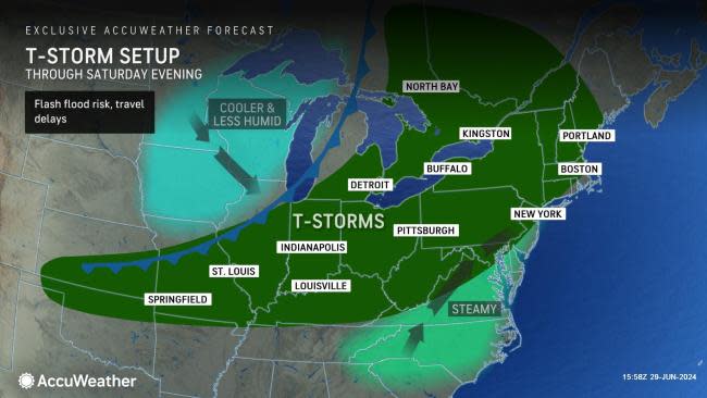
A batch of cooler, less humid air will continue to cycle through the Northeast into Friday night. To some people, it may even feel fall-like. More sensitive people may feel the need to put on long sleeves and a jacket in the evening.
However, a quick turnaround will soon follow.
 |
"People may go to sleep with the windows open Friday night then wake up Saturday morning and notice that the air has turned muggy from New York City on south and west," Dombek said, "Warmth and humidity will quickly build across the region on Saturday."
As the air becomes more humid on Saturday, spotty showers and thunderstorms are likely to erupt.
 |
Then, as a cool front approaches later Saturday to Sunday, thunderstorms may become more numerous. Ahead of the front, high temperatures will be well into the 80s and may touch 90 F in parts of the mid-Atlantic. The surging warmth and humidity will help boost thunderstorms to the point where some will become severe.
On Saturday, severe thunderstorms are forecast to extend along a 1,400-mile-long swath from eastern New York to northeastern New Mexico. A pocket where thunderstorms are most likely to spawn tornadoes will extend from eastern Ohio to western and central Pennsylvania and western New York. However, any severe thunderstorm along the extensive swath will bring the risk of damaging winds, hail and perhaps a brief tornado.
 |
Muggy conditions are in store regionwide on Saturday night with lows in most areas ranging from the mid-60s to the mid-70s.
On Sunday, the severe weather threat will focus along much of the Interstate 95 swath from New England to the lower mid-Atlantic, including the major metro areas from Boston to Washington, D.C., and Norfolk, Virginia, as well as many of the beaches.
 |
People with outdoor plans this weekend may need to closely monitor the weather for changing conditions. Lightning strikes pose a significant danger to those outdoors.
From later Sunday to Monday, temperatures and humidity levels will drop from northwest to southeast across the region in the wake of the front.
 |
By Monday morning, temperatures will dip into the 40s and 50s over the interior Northeast and the low to middle 60s in the mid-Atlantic, which will be 10-20 degrees lower than Saturday night.
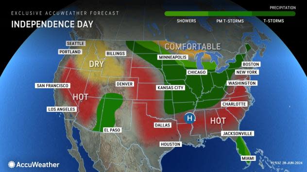
After a couple more refreshing days with low humidity and almost fall-like high temperatures on Monday and Tuesday, heat and humidity will build again from Wednesday to Independence Day.
"At this time, it appears weather conditions will be fairly typical for July 4th in the Northeast with some sunshine and hot and rather humid conditions," Dombek said, "The extent of afternoon and evening thunderstorm activity has yet to be determined this far out."
 |
Widespread highs in the mid-80s to the mid-90s seem likely for Independence Day in the Northeast with cooler conditions possible right on the beaches.
Want next-level safety, ad-free? Unlock advanced, hyperlocal severe weather alerts when you subscribe to Premium+ on the AccuWeather app. AccuWeather Alerts™ are prompted by our expert meteorologists who monitor and analyze dangerous weather risks 24/7 to keep you and your family safer.
