
Clipper storm carrying snow across Great Lakes, Northeast into 2024


A storm from central Canada traveled from the Great Lakes to off the Northeast coast as the final hours of 2023 ticked away and 2024 began. AccuWeather meteorologists caution that spotty snow associated with this storm could make some roads slippery for New Year's travelers.
Storms traveling from western and central Canada to the northeastern United States are often called Alberta clippers. The storms are so named for the lightning-fast wind-powered sailing vessels of the 1800s and their point of origin, the Alberta province of Canada.
 |
However, this Canadian storm is running with its sails rolled up and moving significantly more slowly than most that take a similar path. But, because of the slow-moving nature of the storm, it will have some time to tap moisture from the relatively mild and open waters of the Great Lakes. The weak nature of this particular storm and the chilly but not frigid air in its wake should prevent widespread moderate or heavy snowfall.
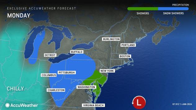
Just enough snow may fall to make some roads slippery, especially where that snow manages to fall into Monday evening, AccuWeather Meteorologist Matt Benz said.
Have the app? Unlock AccuWeather Alerts™ with Premium+
"In most places from the Upper Midwest to the central and northern Appalachians, this storm will produce accumulations of a coating to an inch or so and much of that may be on non-paved surfaces," Benz explained.
Enough snow fell from Sunday night to Monday morning, making some roads slippery in the central Appalachians. However, as temperatures rose slightly during midday, most of the snow melted on the roads. As temperatures dip slightly late Monday, slippery spots may again develop on some untreated roads and other surfaces.
Some major cities that have received a little snow into Monday morning include Cleveland, Pittsburgh and Buffalo, New York.
In the Interstate 95 zone from Washington, D.C. to Philadelphia, New York City and Boston, little precipitation is likely to fall from the storm.
Even a small amount of snow may prompt deicing operations at area airports and may lead to some flight delays.
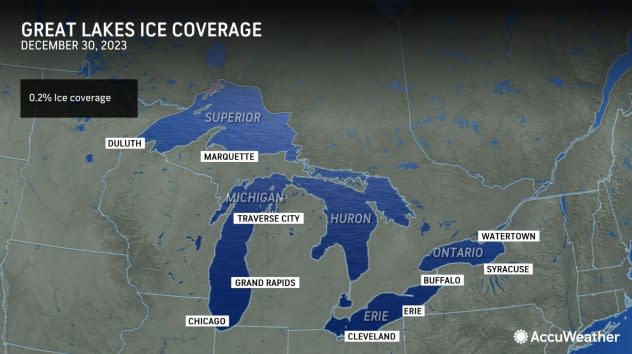
Although the air following the storm is not of Arctic origin, it is cold enough to initiate some lake-effect snow and flurries. The Great Lakes and many of the smaller lakes in the Midwest and Northeast are nearly ice-free as of late December, much to the disappointment of ice-fishing interests.
 |
"A few spots in the northern parts of Minnesota, Wisconsin and Michigan, as well as ski country in western New York and perhaps the Allegheny Plateau in west-central Pennsylvania, may pick up a few inches of snow when combining the storm this weekend and the lake-effect snow that follows around the middle of the week," Benz said.
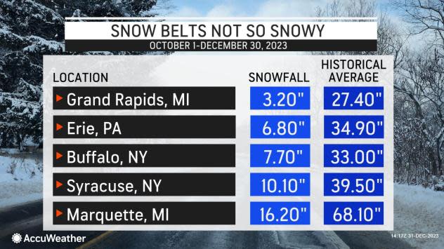
Snow has been nearly non-existent in the mid-Atlantic. However, even areas around the Great Lakes have seen only a small amount of snow relative to the historical average thus far.
 |
Because of the largely open state of Great Lakes waters, any Arctic blast that rolls through as the winter progresses will have the potential to unleash an exceptionally heavy lake-effect snow event.
For now, none seem to be on deck until perhaps toward the middle of the month. It is possible that some Arctic air may become involved with a major storm around Jan. 10-11. The lake-effect snow machine could kick into high gear in the wake of that storm.
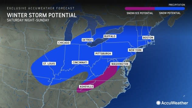
Prior to the central U.S. storm later this month, a winter storm is eyeing the Northeast for the first weekend of 2024.
 |
That storm could produce a swath of heavy snow over the interior Northeast and a wintry mix of snow, ice and rain in the Interstate 95 corridor.
Want next-level safety, ad-free? Unlock advanced, hyperlocal severe weather alerts when you subscribe to Premium+ on the AccuWeather app. AccuWeather Alerts™ are prompted by our expert meteorologists who monitor and analyze dangerous weather risks 24/7 to keep you and your family safer.
