
Cool air to settle across Northeast, heat to ease across South


A batch of cool air will continue to sprawl over the Northeast through the end of the week and will take the edge off the extreme heat in part of the southern United States, AccuWeather meteorologists say.
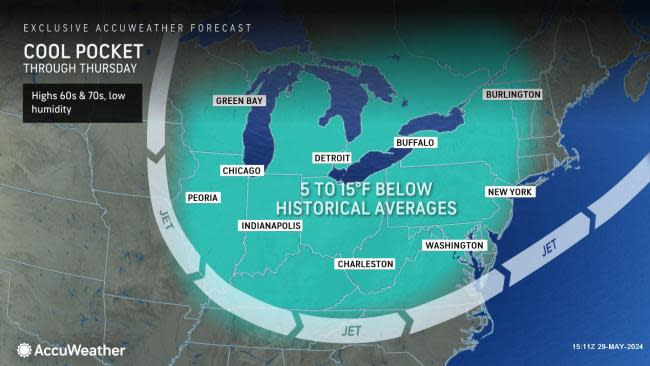
The atmosphere will roll back the calendar from the Great Lakes to the mid-Atlantic and New England states in the coming days. As air streams in from Canada, it will feel more like April or the start of May rather than the end of May for much of the region.
Since the middle of the month, temperatures have generally been above the historical average. However, with the Canadian air streaming in, temperatures will dip from 5 to 15 degrees Fahrenheit below average, which may make the air seem even cooler.
 |
For example, in Washington, D.C., the air will seem refreshing for late May with high temperatures in the mid-70s F through Friday, compared to a historical average near 80, and replacing highs well in the 80s with high humidity from the past week or so.
Comparatively, 300 miles farther to the north, in Rochester, New York, the city will have at least a couple of days with highs in the mid-60s, compared to a historical average in the mid-70s, following a stretch with highs well into the 80s from last week.
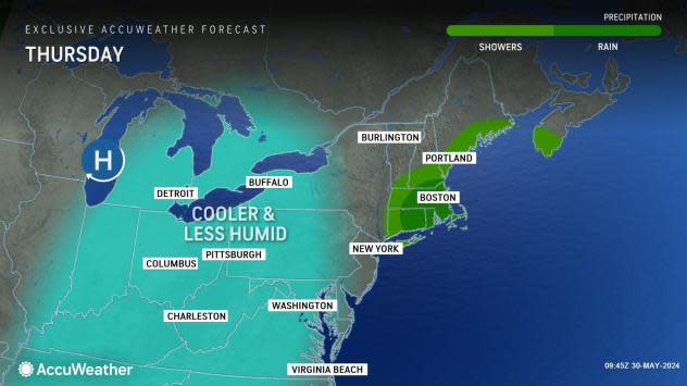
The cooler and less humid air will not be completely free of rain in all areas. While the air will feel cool, it will be much colder several thousand feet up in the atmosphere.
"That setup will create bubbly cottonball-like clouds that can grow into spotty showers and even thundershowers during the afternoon and evening hours, mainly over the interior Northeast," AccuWeather Meteorologist Elizabeth Danco said.
As a disturbance rolls eastward, a few hours of steady rain with some thunder and lightning will pivot to the mid-Atlantic and southern New England coasts into Thursday.
The air may get cool enough to produce waterspouts on lakes Erie and Ontario into Thursday.
Cloud cover and a breeze should hold up long enough at night to prevent frost in most areas. However, there will be some exceptions.
 |
"Right now, it looks like the only areas that may dip low enough, long enough for a frost, will be over the northern parts of Michigan and Wisconsin," AccuWeather Senior Meteorologist Adam Douty said. The chilliest nights in these areas will likely be Wednesday night and Thursday night, when temperatures will dip into the 30s for a few hours.
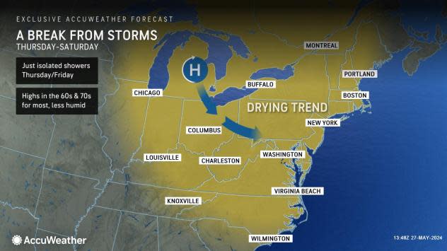
Temperatures and humidity levels will continue to be shaved progressively into the weekend in the Southeastern states, where extreme heat and high humidity have been brutal as of late.
One reduction was already felt on Tuesday over the interior.
"A second reduction will arrive prior to the end of the week and will reach as far south as central Florida," Danco said.
That push of dry air will follow a batch of showers and locally gusty thunderstorms that move from west to east into Thursday, mainly along the Interstate 10 and 20 corridors.
People in Charlotte can enjoy a couple of days with highs in the upper 70s and nighttime lows in the 50s, compared to a historical average high in the low 80s and lows in the 60s. Atlanta may have a day or two with highs in the mid-70s later this week.
 |
Temperatures will still peak well into the 90s around Orlando, with the grueling late-May sun at the theme parks. A reduction in humidity levels will help lower AccuWeather RealFeel® Temperatures by several degrees. The biggest temperature difference will be at night when readings will dip into the 60s.
A warmup will begin from the Upper Midwest late in the week to the weekend in the Northeast. Temperatures will at least return to the historical average or several degrees above. Highs will generally be well into the 70s over the northern tier of the Midwest, Northeast and Central Appalachians, and they will mainly be in the 80s elsewhere, with an uptick in humidity levels.
 |
As the humidity levels climb and moisture flows northward from the Gulf of Mexico, the likelihood of showers and thunderstorms will increase from west to east over the Midwest this weekend and the Northeast by early next week.
"Looking ahead, no big, long-lasting heat is in store until perhaps mid-June," AccuWeather Long-Range Meteorologist Alex DaSilva said, "Around mid-June is when the pattern may flip, and there may be an attempt at building some consistent heat in the Northeast."
Want next-level safety, ad-free? Unlock advanced, hyperlocal severe weather alerts when you subscribe to Premium+ on the AccuWeather app. AccuWeather Alerts™ are prompted by our expert meteorologists who monitor and analyze dangerous weather risks 24/7 to keep you and your family safer.
