
Drought to deluge, budding tropical rainstorm to soak Florida


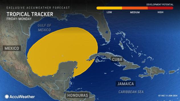

The 2024 Atlantic hurricane season is underway, and AccuWeather meteorologists are closely monitoring the northwest Caribbean Sea and Gulf of Mexico for potential development over the next week. As the week progresses, tropical downpours tracking through the basin have the potential to produce flooding and rough seas for an extended period of time across Florida, and there's even a chance the downpours can organize enough to become a named tropical system.
 |
While there is no sign of a tropical system rapidly forming and intensifying, weak disturbances have recently caused trouble in the form of torrential downpours and flash flooding in some of the northern islands of the Caribbean. This may come to fruition across Florida as well.
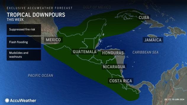
The impacts of the surge of moisture into the western Atlantic Basin will extend beyond Florida, as tropical downpours will become commonplace across Central America and the Greater Antilles this week. Rainfall capable of producing flash flooding, mudslides, road closures and logistical shipping issues will have an extended presence throughout the week.
 |
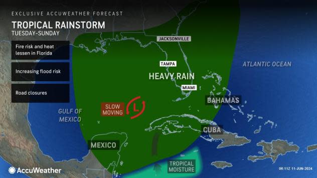
The notable influx of tropical downpours is expected to march into South Florida on Tuesday, which will begin the prolonged stretch of wet and stormy weather. Initially, the rainfall may be welcomed by some, as drought conditions have steadily increased across the peninsula throughout the spring months. In addition to the beneficial rain, the cloudy skies and wet weather will also bring an end to the record-challenging warmth that has been baking the Sunshine State in recent weeks.
 |
While there is a beneficial side to the expected rain, the negative impacts of daily downpours will begin to outweigh the benefits, as flooding will become an increasing concern as the days progress.
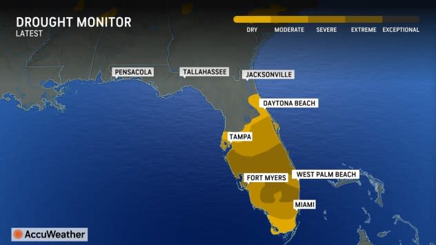
"It's been said that 'all droughts end in floods,' and this may be no different. Central and South Florida is currently experiencing moderate to severe drought conditions. There are portions of central and South Florida that have only received 50-70% of the rainfall they should year to date. This lack of rainfall has led to the expansion of drought conditions this spring," AccuWeather lead hurricane forecaster Alex DaSilva stated.
 |
Fort Myers, Florida, has collected just under 15 inches of rainfall since Jan. 1, which is only 68% of the historical average. Typically, the winter and spring months are the "drier" months across South Florida, while the month of June features the onset of the rainy season courtesy of an increase of daily pop-up thunderstorms. The city has nearly 10 inches of rainfall during an average June, and the upcoming weather pattern has the potential to produce that-possibly more.
Southwest Florida is no stranger to tropical activity with some neighborhoods from Punta Gorda through Naples still dealing with the cleanup from Hurricane Ian back in 2022. While this rainstorm will not produce the same impacts in regard to wind gusts and storm surge, rainfall totals over the week could rival that of some of the powerful hurricanes that have hit the state.
 |
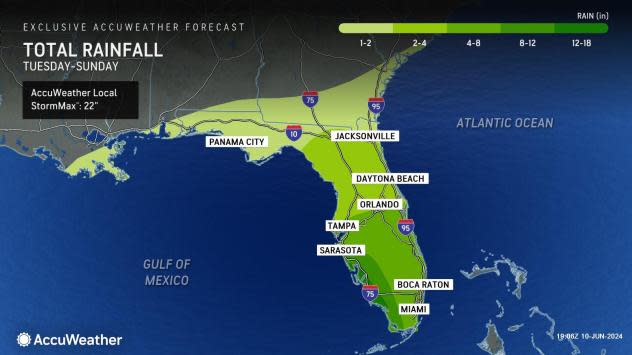
Currently, AccuWeather meteorologists expect tropical downpours to tally up to a whopping 8-12 inches of rain across Southwest Florida, but within this zone where the most intense rain falls, an AccuWeather Local StormMax™ for rainfall stands at 22 inches. The zone of 4 inches or more of rainfall is expected to extend even farther to the north and east into the Tampa Bay Area and on the Atlantic side from Miami to Orlando.
Impacts over the course of the week will slowly spread north across Florida, expanding into the highly populated Tampa Bay Area and Orlando as well. Vacationers and residents alike will want to plan accordingly, as daily downpours can impact plans and potentially pose a risk to lives and property.
 |
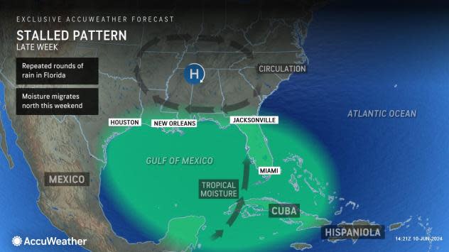
Unlike many tropical disturbances that have moved in and out of Florida rather quickly, this rainstorm will have some staying power due to stalled-out winds in the upper levels of the atmosphere. With the lack of any other storms approaching or strong jet stream winds to move the storm along, the rainstorm will be able to sit and stew across the eastern and central Gulf of Mexico, pumping up rich tropical moisture into Florida for multiple days.
 |
AccuWeather's Tropical Weather Team, led by DaSilva, continues to sound the alert for an extremely busy hurricane season in the Atlantic with multiple threats for the United States. Of the 20-25 named systems predicted, eight to 12 are projected to become hurricanes, with four to seven to reach Category 3 strength or greater.
These numbers are higher than last year and well above the 30-year historical average from 1990 to 2020. Unusually warm waters this year could lead to a significant number of rapidly intensifying storms.
Despite significant pre-season and early-season tropical activity in recent years, the historical average for the first tropical storm is not until June 20, and the first hurricane typically does not form until Aug. 11.
Want next-level safety, ad-free? Unlock advanced, hyperlocal severe weather alerts when you subscribe to Premium+ on the AccuWeather app. AccuWeather Alerts™ are prompted by our expert meteorologists who monitor and analyze dangerous weather risks 24/7 to keep you and your family safer.
