
Eastern US rainstorm, flood risk to precede cold air and snow for some


The same storm responsible for 3-6 inches of rain and localized flooding in parts of western North Carolina will slice across the mid-Atlantic and southern New England into Thursday. In the wake of the storm, noticeably colder air will settle, bringing snow to parts of the Southern states and the central Appalachians before the week concludes, AccuWeather meteorologists say.
After some pre-Christmas chill, milder air returned to much of the East ahead of a new storm. The combination of mild air and moisture from the Atlantic led to areas of dense fog and slow travel on Tuesday and Wednesday mornings and also helped to fuel a storm heading northward from the Southeast.
Enough rain has fallen on parts of Georgia, the Carolinas and southwestern Virginia to have streams and rivers on the rise. Minor to moderate flooding along unprotected areas of the French Broad, Congaree and Yadkin rivers is likely to continue through this week as a zone of heavy rain pivots northeastward.
"The combination of heavy rain and recent burn scars from wildfires this past summer and early autumn may increase the risk of flash flooding and mudslides in portions of western Virginia and West Virginia," AccuWeather Meteorologist Brandon Buckingham said.
Meanwhile, river levels in coastal areas of the Southeast, mid-Atlantic and New England were on their way down earlier this week following heavy rain from last week. These streams will likely experience another water surge from the new storm this week.
The recent rainstorm has left the ground moist to saturated. With low evaporation rates this time of the year, the steady rain that fell over the area Wednesday night was able to trigger quick runoff and flooding.
Among the rivers that faced flooding issues Wednesday night were the Passaic, Ramapo and Raritan in New Jersey. Some rises were also seen along portions of the Potomac, Susquehanna and Delaware in the mid-Atlantic, where minor to moderate flooding remained possible in unprotected areas.
 |
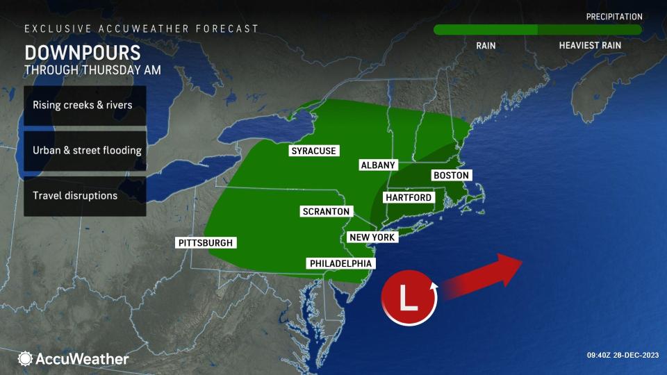
The rain pivoted northeastward, affecting the major Northeast metro areas, including Washington, D.C., Philadelphia and New York City during Wednesday night. On Thursday, heavy rain will continue to pour down for some, leading to urban and small stream flooding as well as travel delays from Long Island to southern New England.
The Thursday morning rush hour from near Philadelphia to New York City will likely be slow due to Wednesday night's drenching rain and lingering runoff.
"The heaviest and steadiest rain is likely to diminish or slide out to the east before reaching central and northern New England," AccuWeather Senior Meteorologist Dan Pydynowski said. "With that in mind, Boston may avoid the heavy rain, and many of the streams and rivers that experience flooding in northern New England should avoid major problems from this storm."
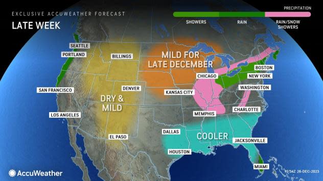
Soon after the storm slides into the Atlantic, cold, moist air from the Central states will spin southeastward.
"Even though the colder air coming in late this week will not be anything unusual for late December for most places, it will be a bit of a shock following temperatures as high as the 50s and 60s in much of the East around the Christmas holiday," AccuWeather Senior Meteorologist Reneé Duff said. "The biggest temperature flip will be from the middle Mississippi Valley to the Southeast states."
 |
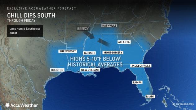
Temperatures will trend 10-20 degrees F lower through the end of the week in the Southeast, and some areas will experience colder-than-historical-average conditions for the end of the month, especially near the Gulf coast.
After a high of 53 in Nashville on Wednesday, temperatures will rise no higher the lower 40s by Thursday as nighttime lows fall to near freezing. The high of 58 in Atlanta on Wednesday will be swapped with highs in the mid-40s on Friday. On Thursday, high temperatures near 65 in Charleston, South Carolina, will nose-dive with highs in the mid-50s on Friday.
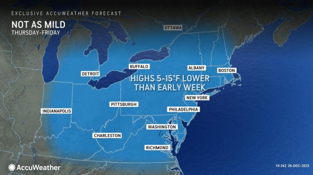
The change to colder weather will be a bit less dramatic in much of the Northeast, especially along the Atlantic coast.
The clouds and rain that started at midweek will ease the temperature drop so that highs in the 30s and 40s from Friday to Sunday will seem to be a bit less of a shock.
 |
That cold patch will likely bring some of the season's first snowflakes to parts of the Interstate 40 and 64 corridors of the middle Mississippi and Tennessee valleys from Thursday night to Friday night. This includes areas as far south as the northern parts of Mississippi, Alabama and Georgia. A coating to an inch of snow may accumulate in a few pockets within this zone.
However, the odds are a bit higher for accumulating snow over the mountains from eastern Tennessee and Kentucky, as well as western parts of North Carolina and Virginia and parts of West Virginia.
 |
Snow showers or very spotty snow is in store for the central Appalachians and interior New England on Friday and Friday night. Any accumulation is likely to be limited to the ridges or grassy surfaces over the intermediate elevations.
Want next-level safety, ad-free? Unlock advanced, hyperlocal severe weather alerts when you subscribe to Premium+ on the AccuWeather app. AccuWeather Alerts™ are prompted by our expert meteorologists who monitor and analyze dangerous weather risks 24/7 to keep you and your family safer.
