
El Niño is dead. Here’s what to expect in the coming months
El Niño has officially come to an end and the ripples from its demise will shake up weather around the globe.
El Niño – a natural climate pattern marked by warmer than average ocean temperatures in the tropical Pacific Ocean – has gripped the planet since the start of last summer. It reached super status earlier this year after boosting temperatures during the hottest year on record and influencing other global weather events.
With El Niño out of the spotlight, its opposite is preparing to take center stage later this summer: La Niña.
For now, neither La Niña nor El Niño are present and a so-called neutral phase has begun, according to NOAA’s Climate Prediction Center. But this will change quickly as La Niña builds through the summer and is likely firmly in control by September during the peak of hurricane season.
Here’s what a summer without El Niño and a budding La Niña could have in store.
Sweltering summer, active Atlantic
La Niña summers following strong El Niño winters have historically been some of the hottest on record in the US. This summer could be no different, even before La Niña is entrenched.
Above-average temperatures are expected over nearly all of the Lower 48 this summer. Sizzling conditions began early in the West and a push of July-like heat is spreading over the eastern half of the country.
The transition to La Niña isn’t the only factor influencing temperatures during the hottest time of the year. They are always on the rise in a world warming due to fossil fuel pollution.

Along with more intense heat, seasonal forecasts show a concerning precipitation trend for a large portion of the western half of the US. Drier than normal conditions are expected for most West states and parts of the Plains.
Dryness and heat are cyclical. The hotter an area becomes, the more it dries out, which could be a recipe for new or worsening drought. A dry area will then get even hotter as most of the sun’s energy goes into heating the ground, with little energy lost to evaporation of wet soil.
The loss of El Niño will also have major ramifications in the Atlantic Ocean and is one major reason experts are calling for a hyperactive hurricane season.
El Niño tends to create hostile upper level winds that rip storms apart while La Niña does the opposite. So, more storms could develop this year without El Niño holding them back. El Niño also won’t be around to curve many storms away from the US, potentially leaving the coasts vulnerable this season.
The Atlantic Ocean’s record-breaking water temperatures could also act like food for storms, helping them to form, strengthen and survive.
The Atlantic is also not the only ocean that’s steamy. Over the past year, El Niño helped drive global average ocean temperatures to record-breaking levels. La Niña may eventually have somewhat of a cooling effect on the world’s oceans, potentially leveling off some of the out-of-control heating of the past year.
But that’s not happening anytime soon. Oceans are incredibly slow to cool, especially since about 90% of the world’s excess heat produced by burning planet-heating fossil fuels are stored in them.
El Niño’s lasting impact
El Niño arrived in June of 2023 and eventually became one of the strongest on record. It influenced the world during its year-long lifetime.
Most notably, El Niño helped push both air and ocean temperatures to record levels globally. Every month from June 2023 to May 2024 was the world’s hottest such month on record, CNN previously reported.
Global ocean temperatures first climbed to record breaking levels in March 2023 and have remained at historic levels since then.
Despite records starting before El Niño arrived on the scene, the toasty climate pattern only exacerbated the situation as record heat in the air seeped into the oceans.
The natural climate pattern also influenced many significant weather events since last summer.
El Niño likely had a hand in hot and dry conditions in northern South America that brought the Amazon River to record-low levels in October, the US Lower 48’s hottest ever winter and severe drought in large portions of central and southern Africa this winter.
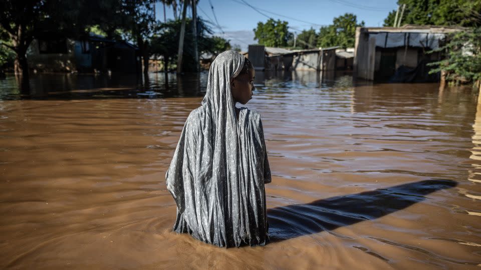
Parts of Africa’s east coast typically record more rain during El Niño events, but excessive rainfall unfolded to devastating, deadly effect in Kenya in April and May.
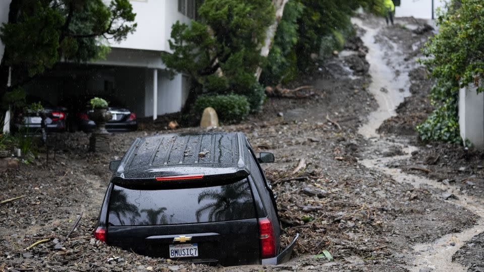
California and the western US also typically pick up more rain during El Niño, especially over the winter months. That played out this past winter when multiple powerful atmospheric river events slammed the West Coast.
Further research is needed to determine El Niño’s full impact over the last 12 months, but these events are proof of the highly influential pattern’s reach.
CNN’s Laura Paddison contributed to this report.
For more CNN news and newsletters create an account at CNN.com

