
First tropical storm of the season heading for Texas bringing risk of flash floods

After days of intense heat that has beaten down on some US states, a tropical storm is heading to South Texas, prompting flood warnings and heavy rainfall.
A potential tropical cyclone is due to move onshore and head inland across southern Texas, bringing with it heavy rain and tropical storm-force winds on Wednesday, the National Weather Service (NWS) has warned.
The weather system, currently named Potential Tropical Cyclone One, was forecast to make its landfall on early Thursday in northern Mexico as ‘Tropical Storm Alberto.’
The NWS said this will bring heavy to excessive rainfall for much of southern Texas this week.
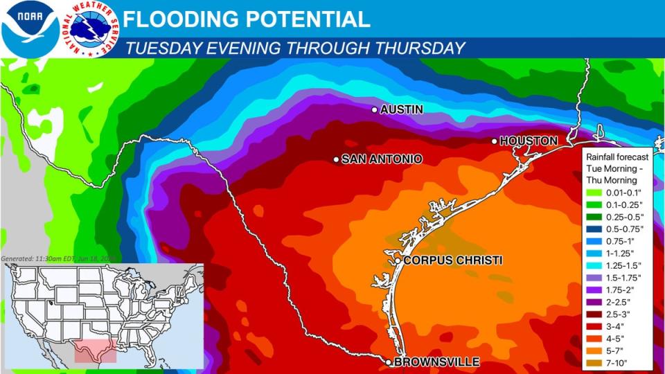
Considerable flash and urban flooding as well as river flooding are all likely in some areas, the National Hurricane Center said, as a result of the rainfall from the potential tropical cyclone that will impact large regions of Central America, northeastern Mexico, and South Texas.
Life-threatening flooding and mudslides are likely in higher areas of Mexico, including around the cities of Monterrey and Ciudad Victoria.
A satellite loop of Potential Tropical Cyclone One over the southwest Gulf of Mexico this afternoon and evening. Associated rain bands are expected to move into south-central Texas Wednesday. pic.twitter.com/zRLO2jXoLI
— NWS Austin/San Antonio (@NWSSanAntonio) June 19, 2024
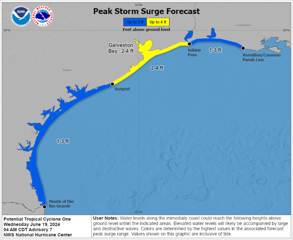
Moderate coastal flooding is also likely, the center has warned, along much of the Texas Coast through midweek. The Texas coast south of Port O’Connor and portions of northeastern Mexico have been issued with a Tropical Storm Watch.
“Small creeks & streams may rise out of their banks, and low-lying areas, especially in urban areas, may easily flood. Turn around, don’t drown!” the NWS wrote on X.
The NWS has stated that more than 50 per cent of flood fatalities are vehicle-related, and has warned those likely to be impacted by the flash and river flooding threats not to risk driving in flood waters.
Tropical Storm Warnings have been issued for many Texas areas such as coastal Jackson, Matagorda, Matagorda Bay, the Gulf Waters, and the Brazoria Counties, NWS Houston said, adding that Flood Watches and Coastal Flood Warnings are also in place along the coast.
Forecasters say that the lower and middle Texas coasts will be mostly impacted by the heavy rain and gale-force winds, along with a coastal front that has the potential to enhance the heavy rainfall inland from the coast.
How sharp the front will get, however, cannot yet be predicted, the NWS said.
The tropical cyclone will also most likely be helped along by the strong high-pressure system that is also currently sustaining the extreme heat wave across the Ohio Valley and the Northeast.
The high-pressure system will steer the cyclone westward towards northern Mexico on Wednesday, and the cyclone could acquire tropical storm status before making landfall early Thursday, the NWS detailed in their daily update.
Heavy rain is also due to sweep west across southern Texas into the Rio Grand Valley over Wednesday night, with rainfalls of five to 10 inches possible from northeast Mexico to South Texas – with a maximum total of 15 inches possible.
The heaviest rainfall is forecast to move west of the Rio Grand Valley into northern Mexico before tapering off early Friday.
The Four Corners region, consisting of the southwestern states of Colorado, Utah, Arizona, and New Mexico surrounding their connecting corners, will experience some of the tropical moisture from the storm, which will activate showers and thunderstorms on Thursday and Friday.
Moisture from a ‘tropical wave’ could also reach northeastern Flordia and coastal Georgia by Thursday night to Friday morning, the NWS stated.
While the tropical activity starts its journey into Texas, the ongoing heatwave will continue to impact areas of the Midwest, including locations in the Ohio Valley, Great Lakes, Northeast, and the Mid-Atlantic, over the next few days.
Daily records and monthly records are expected to be challenged by the very high temperatures, with some heat readings likely to peak from 100 to 105F degrees in some areas.

