
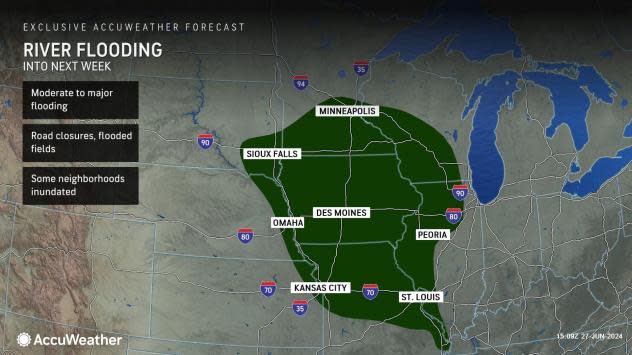
Flooding, rounds of severe weather to persist in central US


More storms packing heavy rain and damaging winds will continue to prowl portions of the central United States well into July. As flood waters recede in some areas, new rain will push river levels even higher in others as the slow-moving disaster continues, AccuWeather meteorologists warn.
Portions of the northern and central Plains to the Midwest will remain in an active pattern that favors rounds of showers, thundershowers and large clusters of severe thunderstorms packing high winds and torrential rainfall into the first week or two of July. The storms will continue to move east to southeast along the northern edge of a large heat dome in the southern U.S.
 |
While some breaks from the storms and rain may last a day or two in some locations, it will rain often enough to keep the ground moist in most areas. However, as has been the case in recent weeks, where the rain persists or repeats, small streams and rivers will surge or remain high.
In the past week, major to record flooding occurred in the zone from northeastern Nebraska and southeastern South Dakota to northern Iowa and southern Minnesota. While rivers have crested or will soon crest in much of this area, the surge of water is working its way to the south and east through progressively larger rivers, including the Des Moines, Missouri and Mississippi.
 |
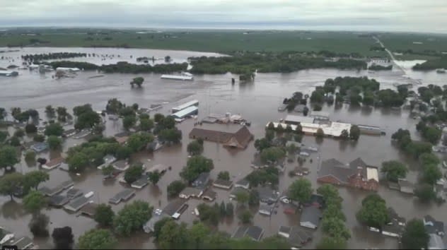
This image shows City of Rock Valley, Iowa on Saturday, June 22, 2024. Gov. Kim Reynolds sent helicopters to the small town to evacuate people from flooded homes Saturday, the result of days of rain.(Sioux County Sheriff via AP) |
River flooding is often referred to as a slow-moving natural disaster. On the secondary rivers, it may take days for flooding to cycle through, while on the largest rivers, such as the Mississippi, it may take weeks for flooding to peak and recede.
AccuWeather meteorologists are concerned that as this surge of water advances downstream over the central Plains, the Upper Midwest and the mid-Mississippi Valley, additional rounds of rain accompanying the surge into next week could push official National Weather Service projected water levels even higher in some locations.
 |
One such round of drenching rain will occur through Friday night over portions of the central Plains to the mid-Mississippi Valley. Another round may affect much of the same area early next week. Meanwhile, more rounds of downpours will coincide farther to the north near the border of Canada.
Minor flooding may escalate to moderate flooding in some areas, while moderate flooding may increase to major flooding. Each level of flood severity results in progressively larger inundation in unprotected areas, such as those without levees or dams.
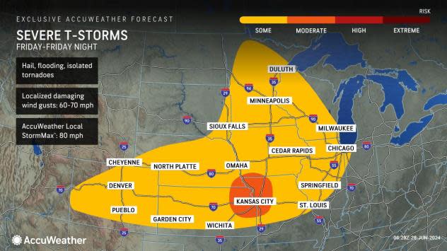
Along with the ongoing flooding concern, rounds of severe thunderstorms packing high winds, hail and a few tornadoes will continue over the Central states on the northern rim of the Southern heat.
On Friday, the severe weather threat will push farther to the east and return to a large part of the Midwest. Widespread severe weather is forecast from northern Missouri to Iowa and northwestern Illinois.
The AccuWeather Local StormMax™ wind gust for the storms will be 80 mph Friday. At this intensity, significant property damage, downed trees and power outages are likely.
 |
"On Saturday, the severe weather threat zone will extend in a roughly west-to-east fashion from Kansas to Ohio with high winds and hail being the major threats," Buckingham said.
More severe thunderstorms are expected to erupt on the northern edge of a resurging heat dome over the South Central states next week.
Want next-level safety, ad-free? Unlock advanced, hyperlocal severe weather alerts when you subscribe to Premium+ on the AccuWeather app. AccuWeather Alerts™ are prompted by our expert meteorologists who monitor and analyze dangerous weather risks 24/7 to keep you and your family safer.
