A heat wave is bringing searing temperatures to New York and the I-95 corridor. Washington DC has hit 100 degrees
A dangerous heat wave is bringing sweltering temperatures to much of the US this weekend, including over parts of the Ohio Valley and mid-Atlantic. Meanwhile, a tropical system could develop this weekend through the southwest Gulf of Mexico. Here’s the latest:
• Millions of Americans under heat alerts: More than 100 million Americans, including those in the highly populated I-95 corridor, are under heat alerts through the weekend. A heat emergency is in effect for Washington, DC, where the temperature skyrocketed to 100º F, the first time the city has recorded a temperature that high since 2012.
• Tropical system could develop: A new tropical system could develop quick this weekend on the heels of Alberto. A system with a medium chance of tropical development could mimic Alberto’s track through the southwestern Gulf of Mexico and into northeastern Mexico this weekend, according to the National Hurricane Center. While this system is not expected to be as large as Alberto, it could bring more rain to South Texas and trigger new flooding concerns there and along the Gulf Coast.
• Sizzling temperatures return to California: Heat alerts in California span parts of southern and central California, including in Colusa County, where firefighters are working to rein in the Sites Fire spanning over 19,100 acres. High temperatures between 100 and 106 are expected and could hinder firefighting efforts. California is seeing an active early fire year, according to the California Department of Forestry and Fire Protection. Since the start of the year, more than 89,700 acres have burned, compared to 5,747 acres during the same period last year.

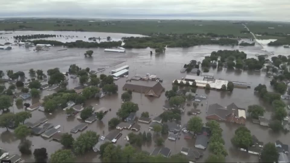
• ‘Catastrophic flooding’ in Iowa: On Saturday, Iowa Gov. Kim Reynolds issued a disaster proclamation for 21 counties in northwest Iowa and directed all available state resources to assist Rock Valley and other communities in response to “catastrophic flooding.” In Rock Valley, all residences north of Highway 18 were being evacuated amid high floodwaters. There’s a level 2 of 4 risk of excessive rainfall Saturday over northern Iowa, and that corner of the state has seen an estimated 10-plus inches of rain based on radar. The heaviest rain is expected further east. And in nearby Sioux Falls, South Dakota, nine people have been rescued in the past 24 hours from rising water due to heavy rainfall, according to City Emergency Manager Regan Smith.
• Flood threat in fire zone: A flash flood warning was issued for Ruidoso and other New Mexico areas burned by the South Fork Fire after 0.5 inches of rain fell in the morning and more rain was expected into the late afternoon hours. Rain earlier in the week created a flash flood emergency with water rescues as a torrent of mud and water rushed from burned areas. Ground charred by fire, also known as a burn scar, loses its ability to effectively absorb water and more easily floods.
• Search for “more loss of life” in New Mexico fires: In New Mexico, authorities reported that at least two people died, 1,400 structures were destroyed and more than 8,000 residents were evacuated as a result of wildfires. The mayor of hard-hit Ruidoso said they were preparing for more fatalities in the fires and bringing in dogs to help the search for “more loss of life.” The South Fork and Salt fires have together burned an estimated 24,000 acres and were still 0% contained as of Friday. Evacuations are still in effect for Village of Ruidoso and City of Ruidoso Downs residents and additional evacuation orders have been issued in at least seven more areas. Ruidoso residents will be allowed to return to their homes Monday, and authorities ask that they bring at least a week’s worth of food and drinking water, as grocery stores are not operating at full capacity. Meanwhile, FBI special agents have joined the investigation into the cause of wildfires.
Heat wave to intensify and expand this weekend
More record daily high temperatures are possible through the weekend as heat expands into new areas and intensifies in others.
The extreme heat and humidity will combine to push the heat index – or how hot it feels – to 100 to 105 degrees over a widespread area, with 110 degrees possible in the southern mid-Atlantic. Record overnight low temperatures will increase health risks by reducing the ability for people to cool down at night.
The nation’s capital could potentially hit 100 degrees for the first time in eight years.
DC Mayor Muriel Bowser said an extended heat emergency will remain activated throughout the weekend and into next week. The National Weather Service said widespread temperatures in the upper 90s and even triple digits will be possible in the city. The city officially recorded a temperature of 100 degrees Saturday afternoon, according to the National Weather Service.
Maryland Gov. Wes Moore on Thursday signed a state of preparedness declaration ahead of the potentially hazardous heat wave. An excessive heat watch has been issued for most of the region for Saturday, according to the National Weather Service, with dangerous heat possible and the heat expected to feel between 105 and 110 degrees.

The heat wave’s prolonged nature is a serious concern. New York City residents could experience 90-degree temperatures or higher this weekend into early next week. The stretch would be the longest ever in June in the city. For the first time this year, the National Weather Service has issued a heat advisory for the city.
Gov. Kathy Hochul on Tuesday announced the opening of the state’s emergency operations center, which she said will monitor conditions and share resources with emergency management personnel across the state’s 62 counties. Earlier this week, New York City Mayor Eric Adams said cooling centers will be open across the city.
Philadelphia has extended a heat health emergency through midnight on Sunday, according to the state’s Department of Public Health. Philadelphia has heat alerts in place through the weekend, with temperatures expected to feel close to 99 degrees.
New Jersey’s heat alerts are in effect until 8 p.m. Sunday, according to the National Weather Service. It will feel around 100 degrees across the state Saturday and Sunday.
Heat is also returning in full force in the West following a brief break. Heat alerts are already in place for portions of California, Arizona and Utah. Temperatures are expected to jump back up to 10 to 15 degrees above normal for Salt Lake City, Las Vegas, Sacramento and Bakersfield, California, through the weekend.
CNN’s Allison Chinchar, Eric Zerkel, Brandon Miller, Taylor Ward, Sara Tonks, Taylor Galgano, Andy Rose, Josh Campbell, Rebekah Riess, and Kara Devlin contributed to this report.
For more CNN news and newsletters create an account at CNN.com


