
How hot will it get? More than 135 million in East sweltering amid intense heat wave
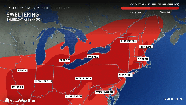

As the official start of astronomical summer got underway on Thursday, June 20, a widespread heat wave across the eastern United States continued to make it feel comparable to the dog days of summer during July and early August. High temperatures into the weekend will continue to soar into the 90s Fahrenheit across much of the Ohio Valley and mid-Atlantic, as well as part of New England.
Since early June, AccuWeather's long-range team of meteorologists has been highlighting the intense heat currently building across the East, as well as the chance of temperatures above the historical average lingering through the weekend.
 |
"Millions [in the East are] at the mercy of a prolonged stretch of 90-degree Fahrenheit temperatures [this week]. The longevity of the intense heat will put additional strain on residents and electrical infrastructure," explained AccuWeather Meteorologist Renee Duff.
Some cities across the mid-Atlantic region, such as Washington, D.C., are even at risk of breaking 100 degrees Fahrenheit by the weekend.
On Sunday, the capital city is projected to reach 101 F, which would not only smash the previous daily record of 98 F set back in the 1980s but also, if it comes to fruition, be the first time the city has eclipsed the triple-digit mark since August 2016.
 |
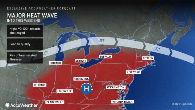
"As high pressure continues to build in the East, the Ohio Valley and Northeast will see daily temperature records challenged on Friday. High temperatures will be between 90 and 100 degrees Fahrenheit and pose a risk for heat-related illnesses across the region," explained AccuWeather Meteorologist Alex Duffus.
The exclusive AccuWeather HeatWave Counter and Severity Index™, which measures heat waves by duration and intensity, quantifies the heat wave in Raleigh, Chicago and Philadelphia as "strong."
Through this weekend, AccuWeather RealFeel™ Temperatures are forecast to reach well over 100 F as the lack of rain and uptick in humidity continue across parts of the region, providing even more discomfort for anyone participating in outdoor activities.
"It is important to remember to stay hydrated when working outside during the day and to take breaks from the heat," pointed out Duffus.
Overnight temperatures will stay elevated across the Northeast, remaining in the 70s and even failing to drop below 80 degrees for some locations. When it remains this warm as people go to sleep, additional strain on the heart can occur as the body tries to regulate its internal temperature.
As the zone of high pressure builds over the East into the late week, much of the Eastern Seaboard and mid-Atlantic region will continue to get little or no rainfall, further exacerbating the sweltering conditions as well as poor air quality levels.
Forecasters say that air quality levels can be unhealthy for sensitive groups, such as children, older populations and those with respiratory conditions, into late week.
"Due to the persistent weather pattern this week, air quality is anticipated to deteriorate significantly, particularly along the Interstate 95 corridor from Washington, D.C., to Boston. The primary culprit behind this decline in air quality is likely to be ozone. It's essential for residents in these regions to stay informed and take necessary precautions during this period," stated Duffus.
Farther north into the Ohio Valley and interior Northeast, forecasters say that sporadic thunderstorms can develop along the ridge and provide some relief from the heat as well as improve air quality levels. Some storms that develop in this zone through Friday, however, can become severe and bring hazards such as hail and gusty winds.
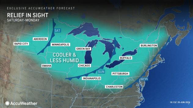
While the heat is expected to last a few more days for many, relief is on the way. A cold front is anticipated to make its way into the Ohio Valley and Northeast this weekend and early next week.
 |
This pattern change will usher in slightly cooler conditions and lower humidity levels, aiding in the recovery of many from the prolonged heat wave. Thunderstorms will erupt along and ahead of the cool front. Where downpours repeat, there may be flash flooding.
"By late weekend, a cold front will slowly progress eastward across the Great Lakes and New England states. The cooler, less humid air following the front will provide some relief for residents in the Midwest and interior Northeast into early next week," noted Duffus.
Additional reporting by AccuWeather meteorology intern Thomas Witte.
Want next-level safety, ad-free? Unlock advanced, hyperlocal severe weather alerts when you subscribe to Premium+ on the AccuWeather app. AccuWeather Alerts™ are prompted by our expert meteorologists who monitor and analyze dangerous weather risks 24/7 to keep you and your family safer.
