
Beryl to target Texas next with flooding rain, strong winds and storm surge


• Beryl will make landfall along the Texas coast by early week as a hurricane but it could turn northward along the coast at the last minute.
• Storm preparations should be completed by Sunday afternoon along the southern and central Texas coast.
• Beryl could stall over Texas, which may result in excessive rainfall and widespread, major flooding in some areas early week.
Even though Beryl weakened over Mexico's Yucatan Peninsula on Friday, it is forecast to regain strength over the southwestern Gulf of Mexico late this weekend before striking Texas early week. AccuWeather meteorologists continue to warn of the potential for widespread flooding rainfall and the likelihood of damaging winds, storm surge flooding and perhaps tornadoes as the system moves inland over Texas.
 |
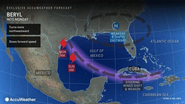
Beryl is forecast to reach the South Texas coast as a hurricane Monday morning. At this time, the eye is forecast to move inland. However, wobbles with the center and the possibility that the storm may try to turn to the north upon nearing the coast at the last minute could push landfall significantly farther to the north in Texas.
Storm preparations should be completed by Sunday afternoon along the southern and central Texas coast as winds, rain and seas will build hours before the hurricane's arrival.
While high winds and rain will not just be focused on the eye, landfall is key for determining the point where heavy rain will wrap inland.
 |
"There will likely be some dry air that is pulled southward along the Texas and northeast Mexico coast as Beryl approaches so that the heaviest rain while the storm is offshore will exist over the Gulf of Mexico," AccuWeather Senior Meteorologist Joe Lundberg said, "But that will change after the center makes landfall."
In most cases, after a hurricane or tropical storm moves inland over the United States, a marked transition takes place, during which the heaviest rain tends to spiral inland or shift to the north and west of the center, Lundberg explained.
Rain is forecast to fall on portions of southeastern and central Texas to bring the risk of flash urban flooding and raise the levels of some area rivers even with slow but steady forward movement of the storm. Portions of northeastern Texas were hit hard by river flooding earlier this spring.
The magnitude of the rain and flooding will depend on Beryl's track and intensity over the western Gulf and also on Beryl's track and forward speed upon moving inland.
 |
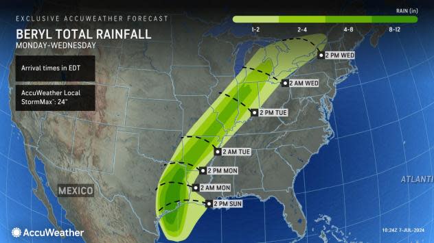
A large swath of 4-8 inches of rain will fall from the southeastern Texas coast to well inland. Within this zone, a pocket of 8-12 inches of rain is anticipated to fall, including in Houston. The AccuWeather Local StormMax™ for Beryl is 24 inches.
Beryl is expected to move along at a steady pace after making landfall and rain is likely to be drawn northeastward with the system as a tropical rainstorm over parts of the middle Mississippi Valley and Great Lakes during the middle of next week. Beryl will be swept up by a non-tropical system moving along over the central part of the U.S.
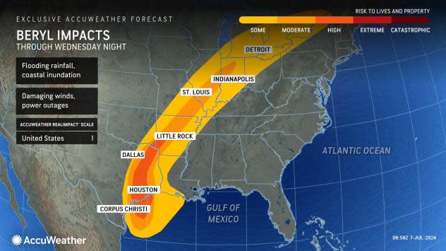
The AccuWeather RealImpact™ Scale for Hurricanes is initially a 1 in the United States for Beryl.
 |
The RealImpact™ Scale is different from the Saffir-Simpson Hurricane scale as it considers all the impacts of hurricanes and tropical storms, as well as the magnitude of damage considering the region's population density. The Saffir-Simpson scale only accounts for a hurricane's current wind speed.
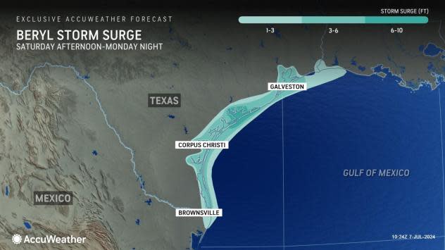
With Beryl forecast to move inland along the South Texas coast late Sunday night to early Monday, a storm surge of 6-10 feet is likely in that area. However, a storm surge of 3-6 feet is likely to occur as far to the north as Galveston Bay, Texas and 1-3 feet can occur as far as the southeastern coast of Louisiana.
 |
Some access to barrier islands may become blocked, and salt water will inundate the streets of some coastal communities.
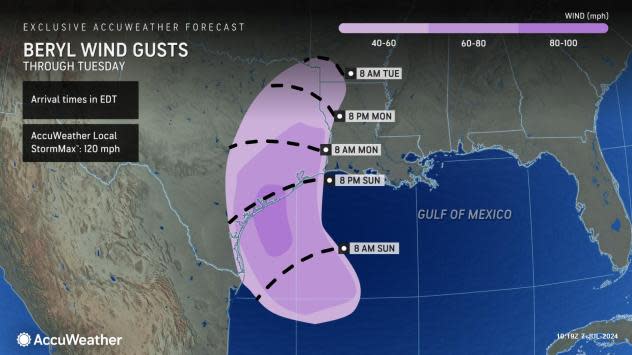
Beryl will bring strong winds to the coast of northeastern Mexico and southern Texas from late this weekend to early next week, AccuWeather Senior Meteorologist Carl Erickson said.
"Winds of a Category 1 hurricane range from 74 to 95 mph and will down trees, cause widespread power outages and significantly damage property. Power outages can last for days to weeks in the hardest-hit areas," Erickson said. Wind gusts can reach 100 mph along the coast near where Beryl makes landfall.
 |
Should Beryl strengthen significantly over the western Gulf of Mexico this weekend, much stronger winds will occur along the Texas and northeastern Mexico coasts.
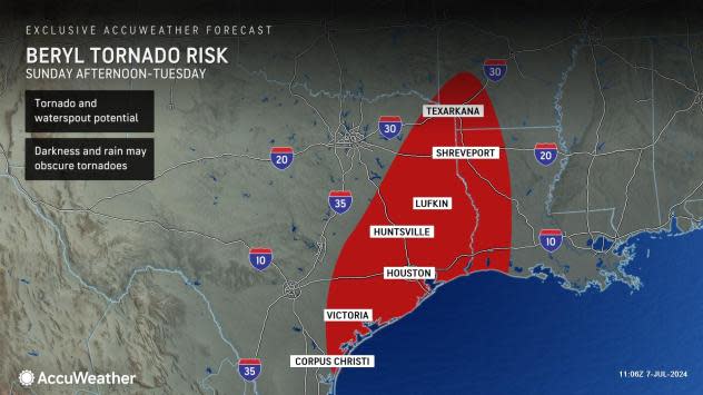
Another factor AccuWeather meteorologists will be monitoring closely is the potential for severe thunderstorms, which may produce waterspouts and tornadoes as Beryl makes landfall and moves inland. Some tropical systems bring a swarm of tornadoes upon making landfall, while others bring very few twisters. If dry air can spiral into the storm's circulation as it moves onshore, the risk of severe thunderstorms and tornadoes may increase, particularly over the storm's eastern and northeastern sections.
 |
A tropical wave of low pressure continued to trail Beryl for a couple of days over the Caribbean. While this feature and its shower and thunderstorms are unlikely to evolve into a tropical storm, some of its moisture may be pulled into the western Gulf region, potentially adding to Beryl's rainfall in parts of Texas.
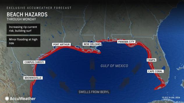
Even though Beryl will push inland over Texas early next week, rough seas and rip currents will increase and strengthen throughout the Gulf Coast this weekend to early next week.
 |
Surf will become dangerous along much of the Texas coast from Sunday to Monday as Beryl approaches and moves inland.
While AccuWeather meteorologists sounded the all-clear for the East coast of the United States and the Florida Peninsula more than a week ago and cleared the zone from the Florida Panhandle to New Orleans several days later, the company's team of hurricane experts continued to warn of the potential for the storm to reach Texas with impacts from rain and wind well ahead of the National Hurricane Center (NHC). AccuWeather also issued an initial storm track map 24 hours in advance of NHC, prior to the storm's arrival in the Windward Islands.
Want next-level safety, ad-free? Unlock advanced, hyperlocal severe weather alerts when you subscribe to Premium+ on the AccuWeather app. AccuWeather Alerts™ are prompted by our expert meteorologists who monitor and analyze dangerous weather risks 24/7 to keep you and your family safer.
