
Hurricane Ian Sucks Tampa Bay Dry Ahead Of Landfall
Stunning video and photos taken along Florida’s western coast show Tampa Bay waterways sucked completely dry ahead of Hurricane Ian’s arrival Wednesday.
Ian’s powerful winds pushed water away from the shore and into the gulf, similar to what happened just before Hurricane Irma’s arrival in 2017.
But experts warned that the receding tide, called a negative storm surge, is only temporary and that water will return, likely at much higher levels.
A possibility we talked about earlier this week is now a reality. #HurricaneIan has sucked the water out of Tampa Bay. This is similar to what happened during Irma 5 years ago.pic.twitter.com/79AE91CtfL
— Cynthia McLaughlin (@CynthiaSNN) September 28, 2022
“Don’t go out there. It’s so dangerous to go out there,” National Weather Service Director Ken Graham said at a news conference Wednesday morning. “Even if you see the water receding, it’s not the time to go out there and look at it and collect shells or whatever it is. We’ve seen this, and these types of storms, when the winds come down, when the winds decrease, that water comes back in and can be incredibly dangerous.”
Florida’s Division of Emergency Management echoed that message on Twitter, warning that the returning water could be life-threatening.
The massive Category 4 storm made landfall near Cayo Costa, roughly 90 miles south of Tampa, later Wednesday afternoon.
9/28 11am EDT: Eyewall of #Ian moving onshore! Catastrophic storm surge along with destructive waves are expected along the southwest Florida coast from Englewood to Bonita Beach, including Charlotte Harbor. Residents should urgently follow evacuation orders in effect. pic.twitter.com/a82s6OGus6
— NHC Storm Surge (@NHC_Surge) September 28, 2022
The low-lying Tampa Bay area is predicted to see a storm surge of four to six feet, with extreme beach erosion and water that may extend several miles inland, according to the National Weather Service.
The storm surge will be greater farther south along the coast, with some areas at risk of a surge of up to 18 feet. In addition, hurricane will dump up to five inches of rainfall per hour as it crosses the state while losing speed and prolonging the deluge, said Graham.
“This is going to be a storm that we talk about for many years to come,” Graham said.
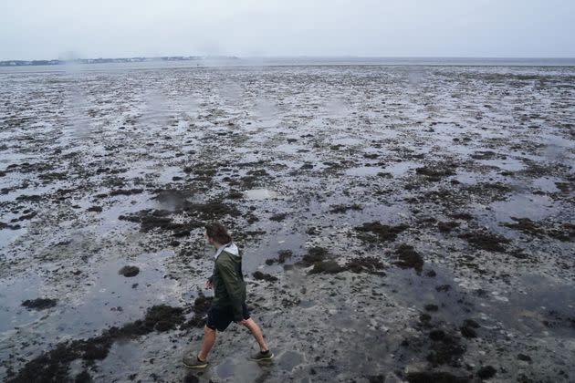
A man walks through the mudflats as the tide recedes from Tampa Bay as Hurricane Ian approaches Wednesday in Tampa, Florida. Ian intensified to just shy of catastrophic Category 5 strength. (Photo: BRYAN R. SMITH via Getty Images)
Water from the storm, not its wind, creates the highest risk to human life, Federal Emergency Management Agency Administrator Deanne Criswell noted. She cautioned that flood dangers don’t end with the storm’s passing.
Only a few inches of rushing water can carry away a moving vehicle, Criswell said. She urged people to move to higher ground if water is rising around them, and cautioned against using a generator indoors due to possible carbon monoxide poisoning.
“Hurricane Ian is and will continue to be a very dangerous and life-threatening storm and this is going to be for the days ahead,” Criswell said.
This article originally appeared on HuffPost and has been updated.
Related...
Hurricane Ian Barrels Toward Florida, Threatening Damaging Floods And High Winds
Cuba Without Electricity After Hurricane Ian Hammers Power Grid
Hurricane Ian Strikes Cuba, Florida Braces For Category 4 Damage
Puerto Rico Still Reeling From Hurricane Fiona As Hurricane Ian Bears Down On Florida
Jan. 6 Panel Delays Hearing As Hurricane Ian Aims At Florida
