
Massive waves sweep away onlookers in California, more dangerous waves on the way
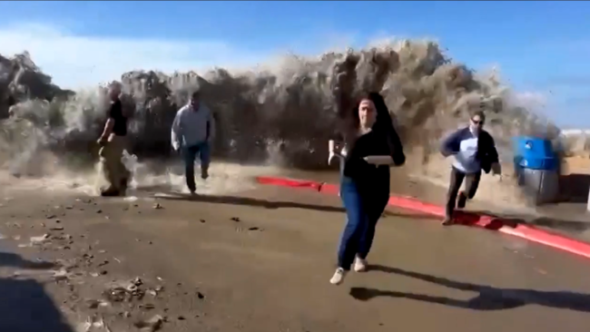
Monstrous waves along the California coast took onlookers by surprise Thursday. Waves as high as 20 feet "crashed over seawalls and swept away and injured several people, forced rescues and sent a damaging surge of water through coastal California streets," according to CNN.
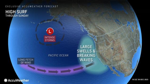
Conditions came together in just the right way, AccuWeather meteorologists say, and ongoing storms will continue to create powerful waves and life-threatening surf into this weekend.
Most of the time, spending a day on the beach or driving along the coast requires little concern and can be a relaxing experience to help melt away stress. However, occasionally, doing so can pose a danger when a storm approaches the coast or when multiple winter storms are busy at sea.
 |
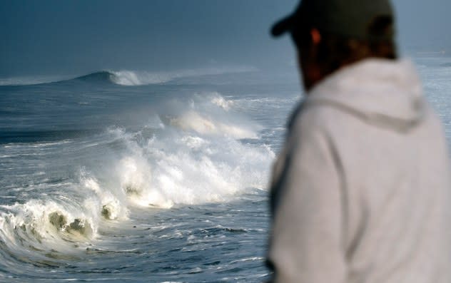
A beachgoer walking along the Manhattan Beach pier watches as rough surf breaks along the beach in Manhattan Beach, Calif. on Thursday, Dec. 28, 2023. Powerful surf is rolled onto beaches on the West Coast and Hawaii as a big swell generated by the stormy Pacific Ocean pushed toward shorelines. (AP Photo/Richard Vogel) |
In the case of Thursday's incident, an extended zone of winds, called fetch, allowed long-period swells to gather and build from multiple storms at sea. These swells then got pushed toward the California coast by west-to-southwest winds.
Long-period swells are related to the strength and distance of winds over the open ocean. Much of the energy from long-period swells is just beneath the sea surface. These long-period swells tend to produce much larger waves as they reach the shallow waters on the coast when compared to the small breakers.
 |
The long-period, wind-generated swells from Thursday produced effects similar to a mini tidal wave but are vastly different. Tidal waves are not produced by wind but by a sudden vertical displacement on the sea floor. Much of the tidal wave's energy is sprawling and very deep below the sea surface. As a result, tidal waves may not be barely noticeable at sea but can extend miles inland upon reaching the coast.
The large swells that arrived on Thursday did not have nearly as long of a wavelength as a tidal wave, so flooding was confined to a block or two. Meanwhile, common small breakers are produced by more local wind effects, have a much shorter wavelength, and have an impact generally confined to the beach. In other words, large swells that reach the coast will generate much larger breaking waves than typical breakers in nearly calm seas.
Moving into this weekend, the extremely long fetch has diminished. However, a more local storm will approach the Pacific coast with gusty winds that will create significant swell, but perhaps not to Thursday's magnitude. Still, large breakers, called sneaker waves, will develop and can strike with only a few second's notice.
 |
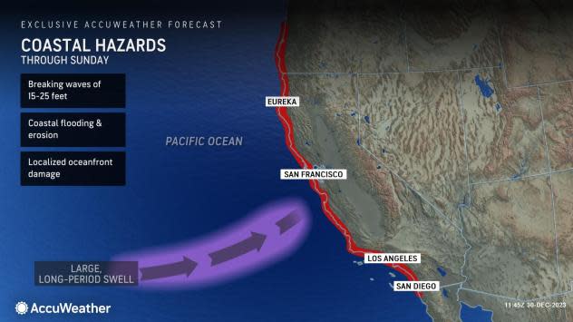
Most of the large waves will average 15-25 feet high at peak in the surf zone. However, some sneaker waves can be significantly higher and extend beyond the beach.
Because of the intense wave action, life-threatening conditions from pounding surf and powerful rip currents will exist.
There is the likelihood of coastal flooding, beach erosion and damage to structures along the coast. Vehicles parked within a block or two of the coast could sustain saltwater damage.
Experts recommend that small craft remain in port and only highly experienced or properly trained craft operators venture out. Similarly, inexperienced borders should avoid the surf in the ongoing conditions into this weekend.
Experts urge people to avoid the beaches and rock jetties that can instantly be swamped by several feet of rushing water. In this case, onlookers will be at risk of being swept away or knocked down, where serious injury could occur.
 |
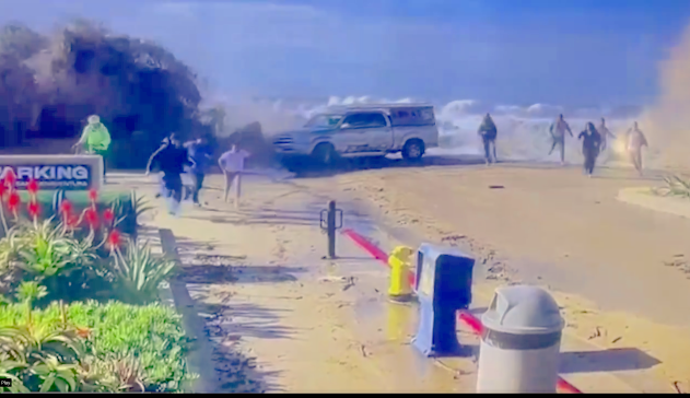
People fled the ocean as monster waves hammered beaches along the California coast Thursday, leaving several people injured. (@VCFD_PIO) |
Large swells and powerful breakers will subside from Sunday afternoon to New Year's Day. However, since the Northern Pacific will remain stormy over the coming months, more rounds of big surf are likely and could happen again late next week or during the first weekend of 2024.
Want next-level safety, ad-free? Unlock advanced, hyperlocal severe weather alerts when you subscribe to Premium+ on the AccuWeather app. AccuWeather Alerts™ are prompted by our expert meteorologists who monitor and analyze dangerous weather risks 24/7 to keep you and your family safer.
