
More storms to rumble in East, Midwest on Sunday


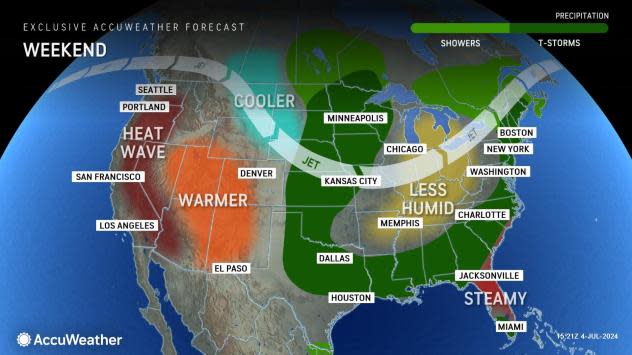
July, sunshine and summertime heat are synonymous with each other, but so are thunderstorms. And, parts of the eastern and central United States will have their share of heavy, gusty and locally severe thunderstorms through the first weekend of July, AccuWeather meteorologists say.
In most cases, thunderstorms that occur this weekend will last only a small part of the day. Most of the storms will erupt in the afternoon heat and decline after sunset. Those with outdoor activities with the extended holiday weekend should check the hourly forecast and radar to keep abreast of changing conditions.
 |
While the overall intensity of severe weather will pale in comparison to the activity that rocked portions of the Central and Eastern states during the spring, all it takes is one severe thunderstorm to strike a populated area at peak strength to pose a significant risk to lives and property.
There are some areas that AccuWeather meteorologists will be watching closely for the severe weather in the coming days. The storms will tend to erupt ahead of and along a push of slightly cooler and less humid air. However, the cool push will pale compared to some that visited the Great Lakes and Northeast in late June to the start of July.
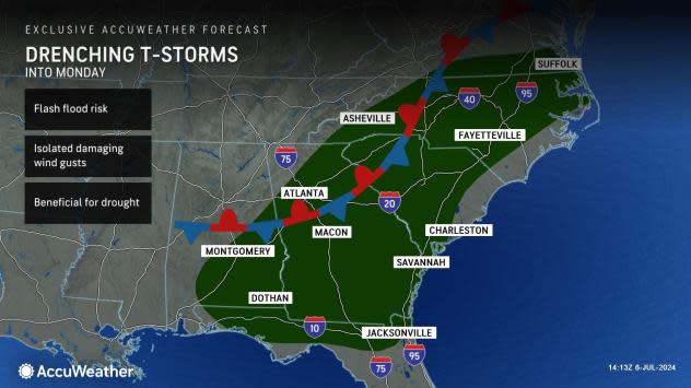
A stationary front sprawling across the Southeast into Monday will usher in drenching thunderstorms from Alabama to Virginia, elevating the flash flood risk. Some storms can be capable of producing gusty winds that can result in isolated damage to property and disrupt travelers.
Although the repeated rounds of storms shifting through the Southeast can result in travel disruptions and other flooding impacts, it may help to put a small dent in the drought levels across the region. According to the U.S. Drought Monitor, a large portion of the region is still facing levels of moderate to severe drought.
 |
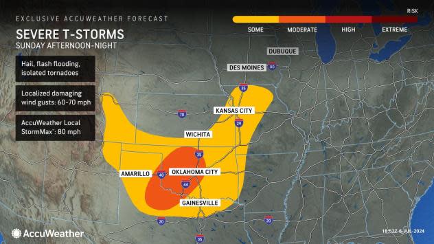
Thunderstorms returned to portions of the Plains on Saturday evening bringing damaging winds, hail, flash flooding and a few tornadoes.
The risk of severe thunderstorms on Sunday will extend from eastern Colorado, far northeastern New Mexico, northwestern Texas on eastward into western Missouri. The main risks of damage will stem from high winds, hail and even an isolated tornado. Localized flash flooding can also occur in the strongest, most persistent storms.
 |
During the coming weeks, the pattern that triggered widespread river flooding in portions of the northern Plains and part of the Upper Midwest will change to a setup that favors longer periods of rain-free weather and surging temperatures. This new pattern should allow streams and rivers from northeastern Nebraska to southern Minnesota to recede substantially.
However, the surge of water will continue to push downstream into the Missouri and mid-Mississippi basins. Many points along the Mississippi River in Iowa and Illinois will be at major flood stages for days to a week or more. The river level at Rock Island, Illinois, is projected to crest near 20 feet early this week, which is within 3 of the record of 22.7 feet set on May 2, 2019.
While points along the lower part of the Missouri River will crest at minor to major flood stage into mid-July, the surge of water on the Mississippi will tend to diminish farther downstream of St. Louis and especially the Ohio River confluence. This is due to areas of abnormal dryness to drought conditions over the Ohio Valley states.
 |
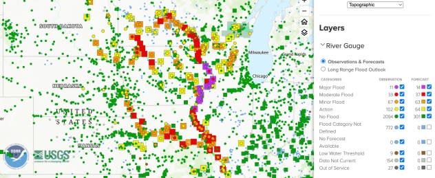
This image from the National Water Prediction Service shows actual (dot) and predicted (square) river levels over portions of the Plains and Midwest as of Friday afternoon, July 5, 2024. (Source NOAA) |
The Ohio River contributes more to the flow of the Mississippi River at the Ohio-Mississippi confluence and farther downstream than the main stem of the Mississippi River north of the confluence. Factoring in the impacts of the upstream rivers, water levels may rise a bit on the lower portion of the Mississippi River in the coming weeks, but significant flooding is unlikely below the Ohio-Mississippi River confluence.
Enough upstream rain will likely keep much of the Mississippi River above critical low water levels through most of the summer. Still, some low water issues are possible along the Ohio River in the short and long term unless rain occurs more regularly in the region.
"A wild card to river levels and drought versus non-drought in the lower portion of the Mississippi River zone to the central Gulf coast late this summer and autumn may depend on the track of tropical storms from the Gulf of Mexico," AccuWeather Lead Long-Range Meteorologist Paul Pastelok said. "As we thought this past winter, Texas was going to be somewhat of a hot spot for tropical systems, and thus far, that seems to be the tendency, especially if Beryl's moisture comes into play."
 |
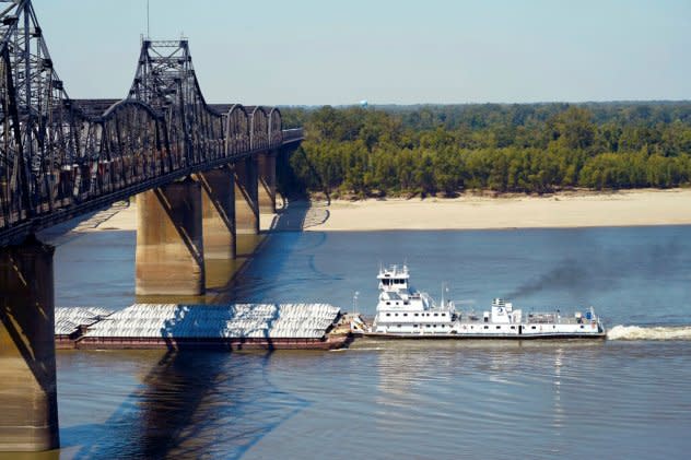
Low-water restrictions on the barge loads make for cautious navigation through the Mississippi River as evidenced by this tow passing under a Mississippi River bridge in Vicksburg, Tuesday, Oct. 11, 2022. The unusually low water level in the lower Mississippi River has caused some barges to get stuck in the muddy river bottom, resulting in delays. (AP Photo/Rogelio V. Solis) |
Sufficient water levels on the Mississippi River are essential for tug and barge traffic on the water highway. Compared to rail, road and air transit, the river system transports a considerable amount of goods at a relatively low cost.
These costs can affect the price of goods that consumers pay at the store. Low water levels during the prior two years hurt barge traffic on much of the Mississippi River.
Want next-level safety, ad-free? Unlock advanced, hyperlocal severe weather alerts when you subscribe to Premium+ on the AccuWeather app. AccuWeather Alerts™ are prompted by our expert meteorologists who monitor and analyze dangerous weather risks 24/7 to keep you and your family safer.
