
Nor'easter to douse New England, mid-Atlantic this weekend


Another weekend is fast approaching, and AccuWeather meteorologists say so is a developing storm that will pack windswept rain and flooding problems across parts of the northeastern United States and Atlantic Canada. Snow may even fall in some places for the first time this season.
The brunt of the storm will be delivered in New England and the Canadian Maritimes, but impacts will be felt elsewhere in the Northeast with some showers and gusty winds predicted.
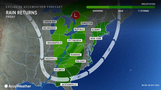
A vigorous storm, which will be lacking in moisture, will drop southeastward across the Midwest into Friday, but it will pick up steam as it pivots toward the Eastern Seaboard.
The Midwest storm will be preceded by a sneaky storm along the immediate Atlantic coast on Friday and is likely to cause drenching rain to streak rapidly northward from eastern North Carolina to southern New England. The rain may be intense enough along the Interstate 95 zone from Philadelphia to New York City and Boston to lead to urban flooding and transit delays. The downpours on Friday can occur at any time in Philadelphia but may hold off until the evening in Boston.
 |
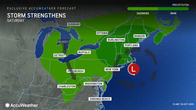
As the Midwest storm reaches the Appalachians, it will begin to harvest some moisture from the Gulf of Mexico and the Atlantic. Then, from Friday to Saturday, the storm will transfer its energy to the Atlantic coast, where a new storm will form and then evolve into a nor'easter as it tracks northward toward New England from Saturday to Sunday.
Much of the East Coast storm's rainfall will bypass the Central states, where widespread drought conditions continue. There will be some rainfall over the Ohio Valley and western slopes of the Appalachians, which may lead to a few feet rise from low water levels on the Ohio River over the next week.
Rainfall will trend upward from the eastern slopes of the Appalachians to the mid-Atlantic coast with the highest amounts on the order of 1-2 inches with local amounts of 3-4 inches in New England, New Brunswick and eastern Quebec from Friday to Sunday night.
 |
For New York City and other locations in the Northeast, this will end up being the seventh weekend in a row where rain fell Saturday, Sunday or both days. The wettest period will be from Friday to Saturday in the Big Apple, when motorists and pedestrians may face flooding in poor drainage areas and difficulties commuting.
Farther south along Interstate 95, from Philadelphia to Washington, D.C., and Norfolk, Virginia, the rain from the storm will tend to be progressively more showery in nature. Friday will be the wettest period, and sporadic urban flooding is possible. A few thunderstorms are also expected through the mid-Atlantic states, especially Friday afternoon into Friday night.
A sweep of dry air may end the rain from southwest to northeast in this corridor on Saturday.
From north of New York City to Boston and across much of Maine, the wettest time will occur from Friday to Saturday night. However, the region will be buffeted by gusty winds even as rain diminishes on Sunday.
 |
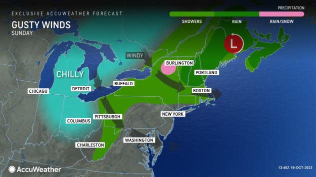
As colder air is injected into the back side of the storm Saturday night to Sunday night, rain may change to snow and bring a slushy accumulation over the higher elevations of the Adirondack Mountains, southeastern Ontario and southwestern Quebec and perhaps a touch of snow over the ridges in the Catskill, Berkshire and Green mountains.
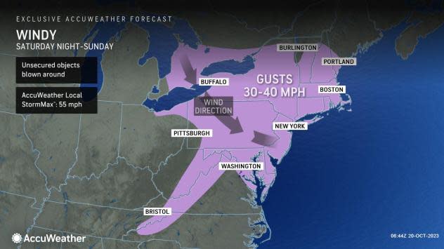
Blustery and chilly conditions will develop over much of the Northeast on Sunday as the storm strengthens. The winds will blow around fallen leaves, dislodge leaves on the trees, toss fall decorations around and may even lead to sporadic power outages. Winds will average 15-30 mph with gusts of 30-40 mph and an AccuWeather Local StormMax™ of 55 mph.
As rounds of rain and wet snow continue in the northern tier of the Northeast and Atlantic Canada, little to no rain will fall on Sunday over the mid-Atlantic, and the sun may even appear.
 |
Actual high temperatures on Sunday will range from the mid-40s F in the Appalachians to the lower 60s near the Chesapeake Bay region in the Northeast, but AccuWeather RealFeel® Temperatures will dip 10-20 degrees lower than actual highs due in large part to the gusty winds. For example, actual temperatures may peak near 50 in Pittsburgh and Cleveland on Sunday, but RealFeel Temperatures will be in the 30s at times with passing showers.
In the wake of the storm, beginning early next week, a long stretch of dry weather is likely to follow in the Northeast and adjacent areas of Canada.
 |
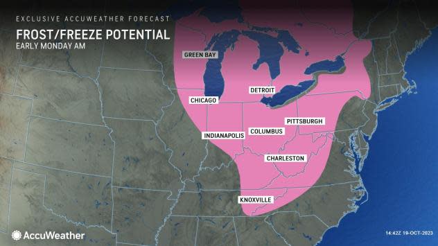
The dry break will bring its share of cold nights, and some of the first frosts and freezes of the season are likely from parts of the Ohio Valley to the Appalachians early next week.
The impending dry stretch may last through the last weekend of October, potentially breaking the string of rainy weekends in New York City and many other locations.
Want next-level safety, ad-free? Unlock advanced, hyperlocal severe weather alerts when you subscribe to Premium+ on the AccuWeather app. AccuWeather Alerts™ are prompted by our expert meteorologists who monitor and analyze dangerous weather risks 24/7 to keep you and your family safer.
