
Pattern flip to bring dramatic change to the West, leading to a big cooldown and even snow
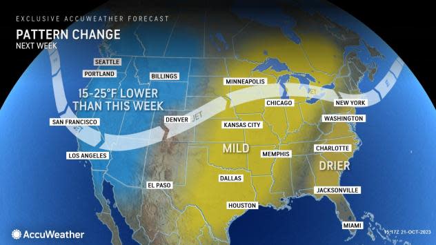


A shocking change in the weather is ahead for the western United States as the recent record warmth will be replaced by much cooler conditions and even some early-season snow, warn AccuWeather meteorologists.
The flip in the weather pattern, driven by a strong cold front, will end the heat wave that has brought record-smashing, triple-digit heat to parts of the Southwest and replace it with temperatures that are several degrees below historical averages. This will represent a downward swing of as much as 25 degrees in daytime high temperatures over the course of less than a week.
 |
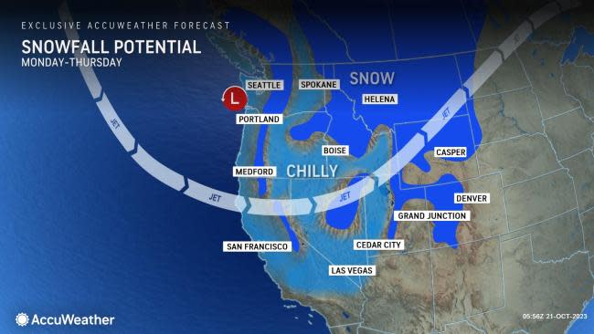
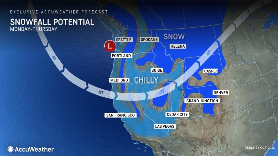
Some storminess accompanying the cooldown could even lead to the season's first widespread accumulating snow for parts of the interior, especially in the northern Rockies.
The first signs of the big drop in temperature sweep across the rest of the interior West and Southwest into next week, say AccuWeather meteorologists.
A new storm with showers will bring substantial cooling from Washington sate down through California, according to AccuWeather Senior Meteorologist Heather Zehr.
The drop in temperature will be delayed, but not denied, in the Southwest. In Las Vegas, near-record highs in the low 90s on Saturday will be replaced by 70s on Monday, according to the AccuWeather forecast. The historical average for this time of year in Sin City is around the 80-degree mark.
 |
Later in the week, San Diego can experience the coolest day of the season thus far. Temperatures may not get above the 70 degree mark, representing the lowest high temperatures for the region since mid-June.
"Temperatures across Central and Southern California much of next week can run 5 to 10 degrees below historical averages," added Zehr.
As is typically the case this time of year when a cool air mass sweeps across the West, AccuWeather meteorologists expect some snow to fall and even accumulate in some areas.
The threat of snow will mainly be confined to the higher elevations, but it is possible that the High Plains of Montana and the hills in the western Dakotas could get some flakes, as well.
On Monday, the mountains in Idaho, Montana and Wyoming could have a period of accumulating snow, including at Yellowstone National Park, while the lower elevations will have a chilly rain.
 |
Later in the week, around Wednesday and Thursday, a more widespread accumulating snow event can unfold and even impact some larger cities such as Billings, Great Falls and Helena, Montana. Where exactly and how much snow falls is not set in stone at this point, but if snow were to fall and accumulate, it would be the first such event of this season.
The prospects of accumulating snow in Montana's biggest cities would represent a drastic change in the weather from the past few days, when temperatures were in the 70s to near 80, close to record levels.
Want next-level safety, ad-free? Unlock advanced, hyperlocal severe weather alerts when you subscribe to Premium+ on the AccuWeather app. AccuWeather Alerts™ are prompted by our expert meteorologists who monitor and analyze dangerous weather risks 24/7 to keep you and your family safer.
