
A pause on summer temps, humidity as cooler air expands into eastern US

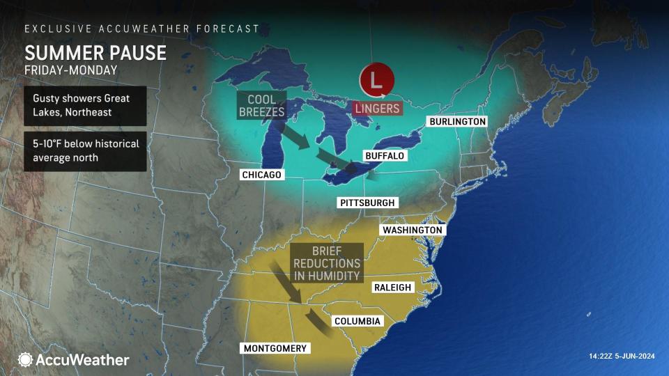


A pause on summer temperatures is in store as cool air will push southeastward into this weekend but will also tend to develop in place and may have some staying power into next week for parts of the East, AccuWeather meteorologists say. A significant drop in humidity will accompany the cool push, even in parts of the Southeast.
The back-and-forth action of cool and warm episodes will become less frequent in the Midwest and Northeast, but refreshing changes in the Southeast are rare in June. The pattern in the coming days may take some extra time to fully evolve along the Atlantic coast, especially in the Southeast. Still, the change to cooler air will waste no time over the interior Northeast.
 |
Cooler, less humid air already made its presence known in parts of the Upper Midwest at midweek.
Temperatures in Minneapolis on Wednesday morning were near 60 degrees, 10 degrees lower than on Tuesday morning. Dewpoint temperatures were about 15 degrees lower. The dewpoint is the temperature level at which the air is saturated or at 100% humidity. The bigger the difference in temperature versus dewpoint, the drier the air is, so it may feel less sticky to many individuals.
The colder air at the middle levels of the atmosphere, as well as disturbances in the jet stream, will make the weather conditions rather complex, if not chaotic, in some cases through this weekend and into next week.
Some days may bring a couple of showers, even a gusty thundershower with hail. Other days through Monday may be almost free of rain in some locations.
 |
The shower activity will be most frequent from the Great Lakes to the Interior Northeast through Sunday.
However, some building cloud cover and spotty showers or thunderstorms can reach the Atlantic coast and dip from the Ohio Valley into the interior Southeast as well.
"The most noticeable drop in humidity levels along the mid-Atlantic coast and New England will be from Thursday to Friday, where Friday will seem more refreshing to some people, especially with an active breeze," AccuWeather Senior Meteorologist Dave Dombek said.
Friday should be noticeably less humid in New York City, Philadelphia and Washington, D.C. The coolest air may not kick in until Friday night and Saturday. Following multiple days with highs in the 80s this week in New York City, temperatures are expected to peak in the 70s for much of this weekend to early next week.
A similar change is likely to be felt across the interior Southeast from Thursday versus Friday, with cities such as Nashville, Atlanta and Charlotte noticeably less humid on Friday.
 |
Coastal areas of the Southeast may remain warm due to intense June sunshine and northwesterly flow of air despite a drop in humidity levels by the weekend.
The drop in temperatures and humidity will help to ease energy bills at a time when the cooling demand is typically on the rise.
Cool air will make its presence known in the pattern from the Great Lakes to the central Appalachians. For example, in Bradford, Pennsylvania, located in the northwestern part of the state, temperatures will be no higher than the low 70s from Friday through Monday. Depending on how extensive clouds and showers are, temperatures may stay in the 50s on one of the days.
Unlike some cool episodes in recent weeks, the extent of cloud cover and a breeze will prevent frost in the traditionally cold spots of the Great Lakes and interior Northeast in the pattern.
 |
One potential spoiler for at least part of the weekend in the Southern states will be disturbances that will track from the central Plains to the lower Mississippi and Tennessee valleys.
The system may not only enhance the cool air but may also bring downpours that are so persistent as to cause localized flash flooding. Some of this moisture and rain may expand over the Southeast states early next week.
 |
Want next-level safety, ad-free? Unlock advanced, hyperlocal severe weather alerts when you subscribe to Premium+ on the AccuWeather app. AccuWeather Alerts™ are prompted by our expert meteorologists who monitor and analyze dangerous weather risks 24/7 to keep you and your family safer.
