
Bolaven will impact Alaska and have downstream impacts on US

Tropical Wind and Rainstorm Bolaven has its sights set on southern Alaska where impacts may begin as the weekend comes to a close, according to AccuWeather hurricane experts. After that, the former super typhoon will help trigger a pattern change and additional storminess downstream in the U.S. later this week.
Bolaven will still pack a punch as it approaches the 49th state as early as the late hours of Sunday, bringing impacts of rain, wind, rough seas, and even interior snow. It will join forces with several other storms swirling in the Gulf of Alaska, a marginal sea of the Pacific Ocean to the south of the state.
The sheer size of Bolaven could even force a change in the weather all across North America later this week, resulting in extreme temperatures and an uptick in storminess on either end of the contiguous U.S., AccuWeather's long-range forecasting experts warn.
 |
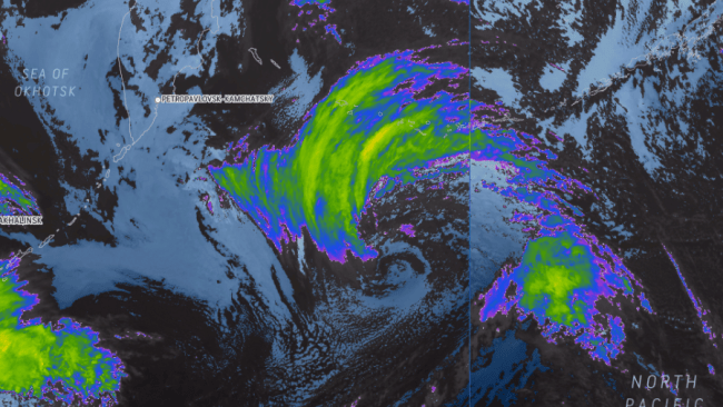
Tropical Wind and Rainstorm Bolaven, as seen on AccuWeather RealVue™ Enhanced Satellite late Sunday evening, local time, Oct. 15, 2023. |
As of Sunday night, local time, Bolaven was spinning well to the southeast of Russia's Kamchatka Peninsula in the northwestern Pacific Ocean.
Some satellites in recent days estimated the peak strength of the typhoon to be at Category 5 levels on the SSHWS, with sustained winds of up to 180 mph (290 km/h) and gusts of 220 mph (355 km/h). This would make Bolaven the second-strongest storm on Earth this year, after Typhoon Mawar late last spring.
Even though it did not make any direct landfalls, Bolaven brought heavy rain and gusty winds to Guam and the Northern Mariana Islands earlier this week. A peak wind gust of 68 mph (109 km/h) was measured on Saipan Island, while nearly 4 inches of rain (101 mm) fell on Agana, Guam, from Monday evening through Tuesday night.
The core of the Bolaven has since moved away from the islands and will churn harmlessly across the vast open Pacific through the remainder of the weekend.
Despite being far away from land, Bolaven wowed meteorologists and weather enthusiasts alike on social media with its symmetrical buzzsaw appearance on satellite imagery and a well-defined, clear eye, which indicated a powerful tropical system.
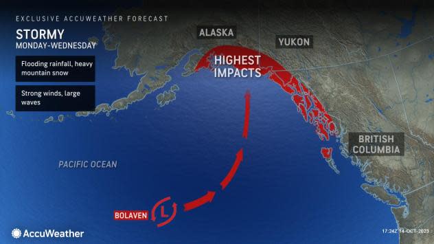
"Despite becoming post-tropical, the storm could end up restrengthening by the early and middle part of the new week as it merges with at least one another storm in the Gulf of Alaska," Lundberg said. "This could potentially bring heavy rain and strong winds to areas from south-central Alaska to the Alaskan Panhandle."
Anchorage and Juneau, the largest and third largest cities by population in the state respectively, could see direct impacts this week, including a heavy, chilly rain that leads to flooding. Around Juneau, and along the south-central coast, wind gusts of up to 50 mph will be possible. Farther inland over the mountains, heavy snow can fall.
 |
In addition to waves pounding the southern Alaskan coast, the sprawling storm will also generate swells that reach all the way to the Pacific Northwest coast of the Lower 48 later this week.
All of the precipitation from what's left of Bolaven is expected to ride the jet stream into western Canada and steer well clear of the northwest U.S., but the massive footprint of the storm will have downstream effects on weather patterns across the lower 48 states, according to AccuWeather experts.
"In response to this storm, the jet stream will bulge northward into western Canada," added Lundberg. "This would translate into a period of warm, dry weather for much of the western U.S., beginning late [this] week."
The jet stream is essentially an atmospheric highway of strong winds located at the level where jets cruise. Winds in this high-speed river of air often reach 250 mph, helping to steer weather systems.
While the jet stream will dramatically shift toward the north in the western U.S., the opposite will be true in the East.
"A downstream dip in the jet stream would be expected over the Plains and Mississippi Valley," Lundberg explained.
This dip could portend a storm along the East Coast of the U.S. in the timeframe of Friday, Oct. 20 to Sunday, Oct. 22, according to Lundberg. This would mean yet another potentially stormy, rainy and windy weekend in the Northeast.
"It's a fascinating connect-the-dots type of pattern," said Lundberg. "What happens in another part of the world really does have an impact on what happens at home."
Want next-level safety, ad-free? Unlock advanced, hyperlocal severe weather alerts when you subscribe to Premium+ on the AccuWeather app. AccuWeather Alerts™ are prompted by our expert meteorologists who monitor and analyze dangerous weather risks 24/7 to keep you and your family safer.
