
Dangerous heat is shifting this week. Here’s where it will go next
Dangerous heat is setting its sights on millions of Americans across the South and Plains on Monday, including several communities recovering from destructive flooding over the weekend. Here’s the latest.
• Heat heads to the South: The unrelenting heat shifts into the South and Southern Plains on Monday and Tuesday, bringing temperatures in the mid to upper 90s. Some cities could even see 100-degree highs, including Dallas and Little Rock, Arkansas. The heat index – a measurement of how the body feels in humidity and high temperatures – could top a dangerous 110 degrees in some areas.
• Minnesota dam compromised: Southern Minnesota’s Rapidan Dam is in “imminent failure condition” after this weekend’s dangerous flooding, Blue Earth County Emergency Management warned Monday. The dam – about 70 miles southwest of Minneapolis – was intact as of late Monday morning, but water was flowing around it. No evacuation orders were issued as of late Monday morning.
• Flood-stricken communities begin recovery amid sweltering heat: Heat alerts on Monday spread over 1,000 miles from North Florida to South Dakota, which was among several states inundated by heavy rain and devastating flooding over the weekend. Heat advisories are in effect for several areas that were swamped with floodwater over the weekend, including parts of northern Iowa, southern South Dakota, eastern Nebraska and northern Missouri and Kansas. President Joe Biden approved a major disaster declaration for Iowa after catastrophic flooding forced some communities to evacuate.
• Record-breaking weekend heat: Daily high-temperature records were broken from New York to Mississippi over the weekend, including some that were more than a century old, as a brutal heat wave embraced the mid-Atlantic and I-95 corridor from Washington, D.C. to New York. Philadelphia hit 98 degrees on Sunday, shattering its 1888 record of 97 degrees. Both Greenville, Mississippi, and Raleigh, North Carolina, saw a record 100 degrees. People in the region can breathe a sigh of relief Monday as cooler temperatures begin to set in.
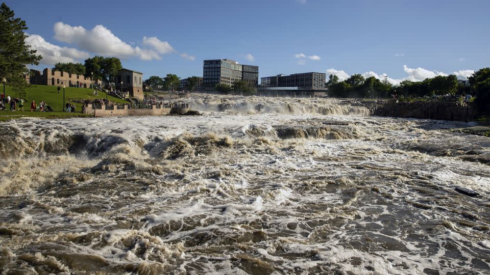
• Flooding turns deadly in South Dakota: At least one person died during severe flooding in South Dakota, Governor Kristi Noem said. “I want to remind everybody to remember the power of water and the flow of water, and to stay away from flooded areas,” the governor warned. At least nine people were rescued from rising water in Sioux Falls, where emergency personnel reported stranded drivers and dozens of trapped vehicles. And the flood threat still isn’t over – several rivers in the state are swollen with floodwater and will continue rising over the next few days, Noem said.
• More than 20 rivers at major flood stage: Flood warnings remain across waterlogged areas of South Dakota, Iowa and southern Minnesota, as well as along rivers that are running well above normal. At least 23 river gauges have reached major flood stage in the area, meaning extensive flooding of buildings, main roadways, and other critical infrastructure is possible, according to the National Weather Service. That number is expected to grow as water continues to collect across creeks and streams, eventually dumping into major rivers.
• “Monsoon-like” conditions coming to the Southwest: An influx of tropical moisture – some of which is from Tropical Storm Alberto – is bringing “monsoon-like conditions” to the Southwest, the Weather Prediction Center said. Thunderstorms are possible through midweek as a result. While the rainfall may be welcomed by firefighters battling several active wildfires in the region, too much rain could trigger flooding and debris flows, making it difficult for crews to access burn areas.
Where heat will go next
A heat dome building over the southwestern and south-central US early this week will push temperatures 10 to 15 degrees above normal each afternoon in an area spanning from the West into the Southeast.
High temperatures in the upper 90s and low 100s are expected Monday from southern South Dakota through the Southeast. A handful of daily record high temperatures could fall in parts of Nebraska and Kansas, and a few are at risk in Mississippi.
The southern tier of the country will remain the epicenter for sizzling conditions Tuesday with high temperatures in the low 100s likely in the southern Plains and Southeast. Atlanta is forecast to top out in the upper 90s both Tuesday and Wednesday, about 10 degrees above normal for late June.
By Wednesday, heat will briefly shift back into some of the same areas of the mid-Atlantic and Northeast that baked last week, but it won’t touch the extreme nature of last week’s oven-like conditions. Temperatures in the upper 90s and low 100s will return in the mid-Atlantic and 90s will return as far north as southern New England.
A few daily high temperature records are in jeopardy Wednesday – including DC and Baltimore – but much of the northeast US will avoid unseasonable heat.
Stormy weather maintains flood threat
There will be rain chances for heavily flooded areas of the Midwest most of this week. A level 2 of 5 risk for severe thunderstorms is in effect over the area Monday and Tuesday and some of these storms could unload rounds of heavy rainfall.
Exactly how much rain falls and where depends on how thunderstorms develop each afternoon, but the heaviest storms could unload more than an inch of rain in a short time. That’s more than enough to cause additional flooding concerns in areas that can’t take much more rain.
Storms are expected to roar to life each day in the late afternoon or early evening hours and remain a threat overnight. Damaging wind gusts and hail are also threats with any severe thunderstorm early this week.
After a brief break on Wednesday, additional heavy rain is possible in the same areas Thursday and Friday.
CNN’s Jamiel Lynch and Andy Rose contributed to this report.
For more CNN news and newsletters create an account at CNN.com

