
Renewal of severe storms across the Plains through early week


Over halfway through May, over 2,600 filtered storm reports have already been gathered due to severe storms erupting across the United States since the beginning of the month. By May 18 of last year, the Storm Prediction Center had gathered 1,707 filtered storm reports, nearly 1,000 fewer than this year. The filtering of storm reports is meant to sift out duplicate reports for the same instance of wind, hail or tornadoes to ensure an accurate count for a particular event.
While this statistic may help put into perspective the magnitude of severe weather that the country has faced so far in May, it also highlights the higher population centers impacted by recent storms.
To start the week, AccuWeather meteorologists are highlighting additional rounds of storms that will emerge over the Central states that can threaten lives and property.
Early Sunday morning, there were indications that storms that develop through the end of the weekend may be capable of producing dangerous and widespread damaging winds in the center of the nation, resulting in the introduction of a rare high risk zone. Storms began to bubble across portions of the Midwest and central Plains Sunday afternoon.
As storms developed Sunday night, the atmospheric conditions were primed enough to produce large hail, defined as quarter- to golf ball-sized, widespread damaging winds and a few isolated tornadoes. Hailstones of these sizes can damage roofs and even dent vehicles.
 |
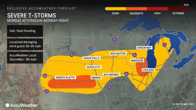
By late Monday, the first storm responsible for bringing severe weather hazards to the Plains over the weekend will shift farther eastward into the Midwest and Great Lakes. Attention will then shift to a secondary feature which will quickly track into the Front Range Monday evening, bringing another round of storms to the central and northern Plains.
"A new storm will emerge from the Rockies on Monday, triggering storms Monday evening and Monday night from Kansas to west-central Michigan. The main threats from these storms are forecast to be hail, flash flooding and damaging winds," noted DaSilva.
Metro areas like Kansas City are among some locations projected to be impacted by storms daily from late weekend early this week. Residents in this corridor are urged to revisit their severe weather safety plan ahead of this active stretch.
 |
A deepening area of low pressure will develop across the Plains Tuesday. Dry air from the north will clash with a moist air mass surging out of the Gulf of Mexico, sparking concerns from forecasters for a potent day of severe weather.
"AccuWeather meteorologists are growing more concerned about a potential severe weather outbreak on Tuesday and Tuesday night from Oklahoma to Michigan. A very powerful storm will strengthen as it moves northward into the Midwest," stated DaSilva.
Dew points can surge into the 70s Fahrenheit ahead of the line of storms from eastern Oklahoma to portions of Missouri, while locations across the northern Plains behind the main line of storms can observe dew points in the 40s and 50s F Tuesday.
 |
This distinct boundary between the two air masses will encourage the potential for volatile storms. AccuWeather meteorologists are now highlighting a high risk for severe thunderstorms from Tuesday to Tuesday night.
DaSilva highlighted that millions of people could be at risk for severe weather in major cities such as Kansas City, St. Louis and Chicago. Damaging winds, hail, flooding downpours and isolated tornadoes will all be risks within storms Tuesday.
"It will be important to monitor the storm's track, as small changes in the storm path can lead to shifts in where the core of the severe weather sets up," said DaSilva.
 |
By the middle of next week, energy from the storm will press farther eastward. Forecasters have outlined a corridor to face some risk of severe weather between Wednesday and Wednesday night.
On Wednesday, the strongest storms that develop from areas of western Texas as far north and east as Michigan and western New York can produce downpours, gusty winds and hail.
For Thursday, forecasters are also highlighting a zone across portions of northeast Texas, Oklahoma, Arkansas and northwest Louisiana for some risk of severe weather. Wind gusts can rise to speeds of 60-70 mph with the AccuWeather Local StormMax™ of 85 mph.
 |
As storms ramp up from the afternoon to evening hours, flash flooding will become a major concern, especially after some of these locations faced heavy rainfall and flooding over the previous week.
Want next-level safety, ad-free? Unlock advanced, hyperlocal severe weather alerts when you subscribe to Premium+ on the AccuWeather app. AccuWeather Alerts™ are prompted by our expert meteorologists who monitor and analyze dangerous weather risks 24/7 to keep you and your family safer.
