
Robust Pacific storm to lurk off California coast, instigating rounds of rain and mountain snow
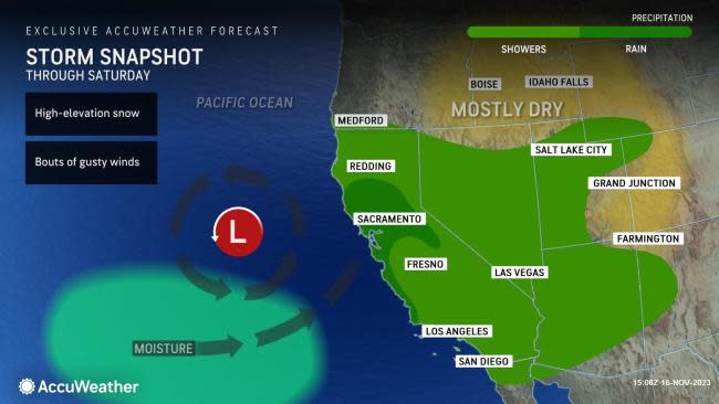

AccuWeather meteorologists say that pockets of Pacific moisture will be ushered into California during the rest of this week as a robust storm lurks offshore, spreading intervals of rain inland from the coast and even some accumulating snowfall to the peaks of the Sierra Nevada.
Earlier this week, rounds of showers dampened parts of Northern California, Oregon and Washington. Rainfall totals generally remained below the 1-inch mark although some coastal locations and upslope regions in far northwestern California and western Oregon picked up just over an inch of rainfall from Monday to early Tuesday morning.
On Wednesday, an influx of moisture finally reached across areas of Southern California. Rainfall totals in downtown Los Angeles rose to 0.34 of an inch, breaking the 20-day dry streak for the city. Across the higher terrain farther inland, 24-hour totals on Wednesday ranged between 1.00 and 1.75 inches across the San Gabriel Mountains.
Locations farther south into San Diego County collected anywhere from 0.15 of an inch near the coast to upwards of 1.50 inches in the higher terrain of the northwest portion of the county. In the city of San Diego, roughly 0.14 of an inch of rain was observed on Wednesday, which was a higher total than collected in September and October combined.
There will be numerous opportunities for rain across parts of California through Saturday as this feature circulates nearby.
 |
Locations along the northern and central coast of California, as well as the foothills of the Sierra Nevada, will stand the best chances for rainfall totals between 1 and 2 inches through Saturday. However, upslope regions across coastal Southern California could easily pick up an inch of rain during this time frame.
Rounds of gusty winds will impact coastal locations through the end of the week. Forecasters warn that gusts can reach up to 20-30 mph during this time frame directly along the coast of Central and Northern California; however, there will be a heightened risk for boaters and mariners offshore where winds will be stronger.
As this stormy pattern persists, temperatures across much of the state are forecast to decline gradually. Temperatures will dip closer to typical mid-November values by the start of the weekend.
 |
"Periods of rain will continue into Friday across San Francisco as pieces of energy rotate around the center of the storm," AccuWeather Senior Meteorologist Heather Zehr said.
Zehr added that the storm's center will head back toward the Bay area Friday.
Rainfall is not likely to be excessive around San Francisco; most places south and east of the Bay Area are on track to receive 0.25-0.50 of an inch while the city, North Bay and areas along the coast may end up with 1-2 inches of rain, with locally higher amounts that can result in localized flooding.
Although San Francisco is not facing drought conditions, only around 0.07 of an inch of rain has fallen there from June through October. November has already proved to be wetter than all of those months combined, with more on the way.
Rounds of rain over the upcoming days can result in ponding on roadways and flooding in low-lying areas. It is recommended that motorists allow for extra time to reach their destinations and take caution when driving on wet roadways.
Flight delays or cancellations will be likely as gusty winds and persistent rainfall spread across the region. Travelers taking an early trip home ahead of the Thanksgiving holiday should closely monitor for any updates on delays or cancellations.
Only a handful of ski resorts have opened up so far this season, and those that have opened have had to rely primarily on machine-made snow for the few slopes in operation.
Forecasters say this storm may bring accumulating snowfall to the higher elevations of the Sierra, with the best chances generally above 8,000 feet.
 |
"Ski resorts in the Sierra Nevada have also been anxiously awaiting the first major snow of the season, and that too appears to be possible as the storm slowly shifts inland through the weekend," AccuWeather Meteorologist Brandon Buckingham said.
The high-elevation snowfall may occur again from Friday into Saturday, forecasters say, as pieces of energy associated with the storm swing inland across California.
"Although the wet and snowy weather can create headaches for any early Thanksgiving holiday travelers this weekend, the wet weather can effectively end wildfire concerns across California through at least the rest of November," added Buckingham.
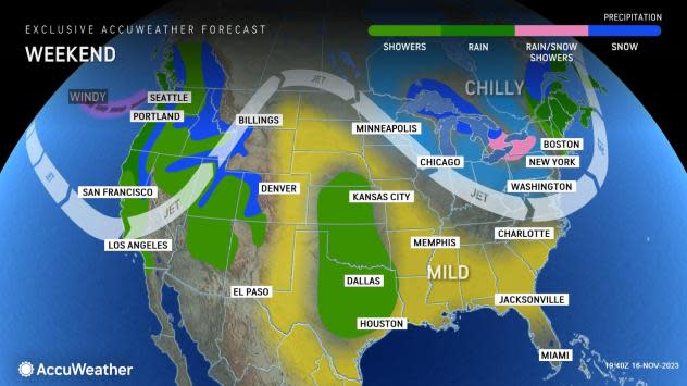
The storm is expected to track inland and move across the Rocky Mountains and interior Southwest states through the end of the weekend. However, by early next week, calmer conditions are expected to arrive in the West.
"There is good news for people planning on traveling early next week into or out of places like Seattle, San Francisco, Los Angeles, Las Vegas and Phoenix, as a return of dry and mild conditions is expected. Across much of the Southwest, dry conditions can extend from the beginning of next week and continue right through Thanksgiving," noted Buckingham.
Want next-level safety, ad-free? Unlock advanced, hyperlocal severe weather alerts when you subscribe to Premium+ on the AccuWeather app. AccuWeather Alerts™ are prompted by our expert meteorologists who monitor and analyze dangerous weather risks 24/7 to keep you and your family safer.
