
Rounds of heavy April rain to boost flood risk in parts of central, eastern US

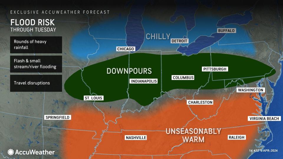

Along with the likelihood of severe weather, the risk of repeating rainfall and flooding problems will continue over the middle of the United States in the days ahead as large storm systems move slowly through the region and repeat, AccuWeather meteorologists warn.
Two main episodes of drenching rain are likely through the middle of April, said AccuWeather Senior Long-Range Meteorologist Joe Lundberg.
The first batch of rain began along a weather front that stalled from the central Plains to the Ohio Valley states to the central Appalachians during the Easter weekend. That weather battle zone will persist into nearly the middle of the week.
 |
Thunderstorms will erupt and repeat near the warmer air in this zone while steadier rain falls just to the north of the thunderstorms. As each pulse rolls eastward, the ground will become increasingly wet. Once saturated, the risk of flash flooding of small streams and areas that drain poorly will increase.
Surges of water on the secondary rivers may lead to flooding in unprotected areas. Some of the secondary river basins that may experience flooding problems include the Wabash in Indiana, the Illinois River in Illinois and the Miami and Scioto rivers in Ohio. There will be surges along many of the rivers in the central Appalachians and part of the mid-Atlantic as well. The Potomac is one of the larger rivers in the East that could experience flooding.
 |
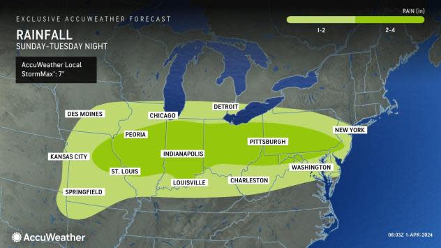
From 2 to 4 inches of rain with locally higher amounts may fall on portions of Missouri, Illinois, Indiana, Ohio and Pennsylvania through Tuesday night. The AccuWeather Local StormMax™ rainfall is 7 inches through Tuesday night.
"Following the barrage of heavy rain and severe weather into Tuesday, a break of dry weather is in store for several days during the middle and latter part of this week," AccuWeather Long-Range Meteorologist Brandon Buckingham stated.
This will allow the small streams and secondary rivers to recede and the topsoil to begin to dry out.
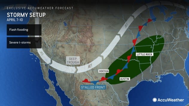
However, more heavy rain seems likely from parts of the Plains to portions of the Mississippi Valley before the middle of the month.
As more storms roll across the western U.S. and re-emerge over the Plains, the moistening process will resume in the form of more drenching downpours and severe thunderstorms, AccuWeather Chief On-Air Meteorologist Bernie Rayno said.
Overlapping rain from the first and second rounds may increase the risk of flooding.
 |
"The downpour zone is likely to extend from central Texas to the mid-Mississippi and Ohio valleys and begin next weekend and continue into the second week of April," Rayno explained.
Pockets of abnormally dry to extreme drought conditions have emerged from western Tennessee to Iowa and Minnesota. So, the upcoming rains will help in this case, but too much rain may even fall in these areas and lead to flooding problems or soggy fields.
The runoff through mid-April will gradually work its way into the secondary rivers then the main rivers, such as the Ohio and Mississippi.
From parts of the central and southern Plains to portions of the Midwest, pockets of 4-8 inches of rain may fall from late March to the middle of April.
Enough rain will fall to lead to significant rises on the secondary rivers and the surge of water moving downstream on the Ohio and Mississippi should be enough to alleviate any low water level concerns for much of the spring and perhaps into the first part of the summer.
During the past two years, low water levels on much of the main stem of the Mississippi River greatly hindered tug and barge operations. River levels tend to drop from the midsummer to the winter, barring major storms. A lack of large complexes of thunderstorms over the Plains and Mississippi Valley during the summer could result in abnormally low water levels and limited barge operations.
 |
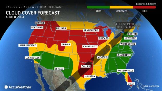
The anticipated cloud cover from the moistening pattern early next week could foil viewing of the upcoming total eclipse in parts of the Central states.
Want next-level safety, ad-free? Unlock advanced, hyperlocal severe weather alerts when you subscribe to Premium+ on the AccuWeather app. AccuWeather Alerts™ are prompted by our expert meteorologists who monitor and analyze dangerous weather risks 24/7 to keep you and your family safer.
