
Rounds of rain to quench drought-stricken central US

Soaking rainfall will converge on drought-stricken areas of the central United States this week and beyond, AccuWeather meteorologists say. The needed rain is likely to provide a boost to the Mississippi River, which has reached historic lows in some places.
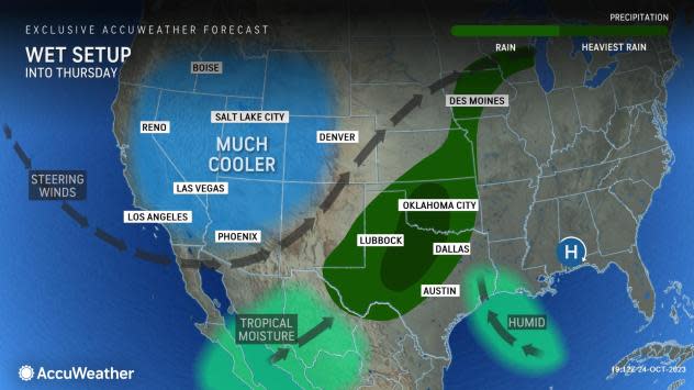
Three weather systems will work together to bring a couple of rounds of rain this week from the southern Plains to part of the Upper Midwest, AccuWeather On-Air Meteorologist Bree Guy said.
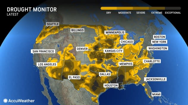
Severe to exceptional drought conditions are gripping large swaths of the Central states, according to the United States Drought Monitor.
 |
"Tropical moisture from Norma is already streaming northeastward from Mexico, while a dip in the jet stream continues to dive into the West and, as the week progresses, a cold front will drop slowly southward across the Plains," Guy said.
Norma, once a major Category 4 hurricane while spinning over the East Pacific, struck the southern tip of Mexico's Baja California Peninsula as a Category 1 hurricane on Saturday afternoon. It continued to lose wind intensity and weakened to a depression before making a second landfall along Mexico's western coast on Monday morning.
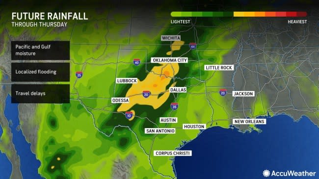
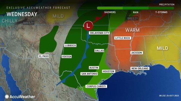
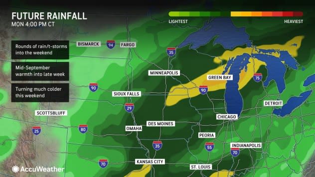
On Wednesday, areas of rain will extend from the Big Bend area of the Rio Grande River through northern Texas and into much of Oklahoma and central and eastern Kansas. Although much of the rain is expected to be beneficial, it may come at the risk of localized flooding in some locations.
 |
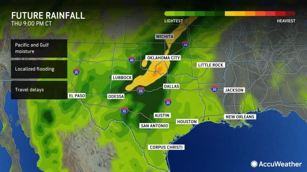
Guy explained that the rain will continue to the north and northeast over the Plains and will continue to join up with rain from a front sagging into the Great Lakes region through Thursday. The dip in the jet stream over the West will help to pull some Gulf of Mexico moisture northward into the mix.
A general 1-2 inches of rain will fall into Thursday from much of central Texas, north to central Oklahoma, eastern Kansas, northwestern Missouri, eastern Nebraska, much of Iowa and Wisconsin, as well as southeastern Minnesota and much of northern Michigan. Because the majority of the rain will fall over one to three days, non-paved areas will generally absorb it well with little runoff.
 |
However, there will be some exceptions. A few pockets of 2-4 inches of rain will occur with locally higher amounts and may generate some runoff that will work its way into the progressively larger streams and rivers. In one to three weeks, there may be a several-foot rise on the main stem of the Mississippi River.
One such zone that has a greater chance of experiencing flash flooding is along the Interstate 35 corridor from Dallas to Oklahoma City. This area or perhaps just to the west or to the east has the potential to pick up 4-8 inches of rain in as many hours from Wednesday to Wednesday night. Rainfall of this magnitude is likely to rapidly run off regardless of soil conditions or the scope of paved areas versus exposed soil.
Urban flooding incidents will be rare with this event, but a few downpours and blocked storm drains could lead to some isolated flash flooding.
Looking ahead, a wave of much colder air will likely set up a noteworthy temperature boundary or front that will stall over portions of the Plains and Ohio Valley next week, AccuWeather Lead Long-Range Meteorologist Paul Pastelok said. That could be the trigger for another rain event.
 |
"There is the potential for a thorough soaking in some areas next week that includes the Ohio basin," Pastelok said, adding that the exact details, including the precise location and magnitude of the rainfall are not yet clear.
Following windblown snow and plunging temperatures near the headwaters of the Missouri River over the northern Plains and Rockies this week, another batch of snow may develop on the northern end of next week's rain event over the Midwest.
A soaking rain that brings a couple of inches along the Ohio River could further boost Mississippi River levels as runoff from this week will continue to trickle downstream from the Upper Mississippi, Missouri and Arkansas rivers.
 |
Water levels at Memphis, Tennessee, were hovering near minus 10 feet this week due to dredging operations and erosion that lowered the bottom of the river relative to the original gauge placement. The lower portion of the Mississippi River has been flirting with record low levels in recent months. A low flow rate relative to the historical average has allowed salt water from the Gulf of Mexico to creep upstream to the New Orleans area, where drinking water was being threatened.
AccuWeather meteorologists began emphasizing that much-needed rain would return with potential drought relief since early last week.
Want next-level safety, ad-free? Unlock advanced, hyperlocal severe weather alerts when you subscribe to Premium+ on the AccuWeather app. AccuWeather Alerts™ are prompted by our expert meteorologists who monitor and analyze dangerous weather risks 24/7 to keep you and your family safer.
