
Rounds of severe storms to pack high winds, torrential rain in Midwest

The same setup that will allow heat to build eastward over the Rockies and Plains will play a role in episodes of severe thunderstorms over a large portion of the north-central United States, AccuWeather meteorologists warn.
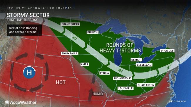
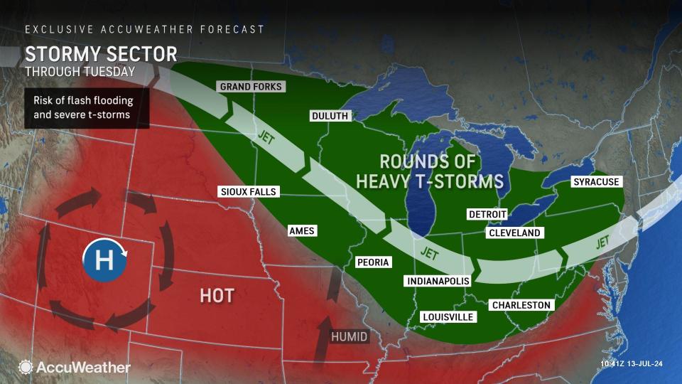
While a large area of high pressure creates a massive dome of heat and limit thunderstorms over part of the middle of the nation, thunderstorms will erupt on the fringes of the heat from this weekend into the new week.
One area in particular, from the southern Canada Prairies to the northern Plains, Great Lakes and Ohio Valley, will be in the zone where thunderstorms can occur nearly daily through Tuesday. In this zone, many of the thunderstorms experienced will be part of large complexes.
 |
When thunderstorms organize in this way, they can sustain themselves, cover hundreds of miles per day and last through the night. In some cases, the storms can cause damaging winds, hail and flash flooding, while in other episodes, they merely bring downpours, breezes and some short bursts of thunder and lightning.
The first storms in the pattern erupted on Saturday night across the northern Plains and northern Midwest and brought a mixed bag of storm reports including damaging winds, hail and flash flooding. Several locations in South Dakota reported wind gusts over 100 mph.
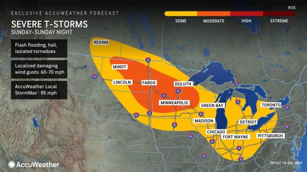
On Sunday, the zone of severe thunderstorms will re-organize over the Dakotas and Minnesota, before rolling or expanding into much of Wisconsin. The severe weather threat on Sunday to Sunday night will extend southward to cover northeastern Illinois, northern Indiana, much of Michigan, northern and central Ohio, western New York and northwestern Pennsylvania.
 |
Similar to Saturday night's threats, the strongest storms on Sunday will bring high wind gusts, hail and the potential for flash flooding. However, isolated tornadoes are also possible.
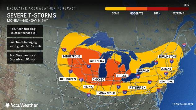
On Monday, the severe weather threat zone will become more elongated and extend from the eastern part of the Dakotas all the way to northern Maryland and western Maine. Within this zone, more concentrated zone of severe weather will extend from eastern Minnesota to much of the Lower Peninsula of Michigan and into southwestern Ontario.
Once again, the main threats will be high wind gusts and torrential downpours. A few of the strongest storms can produce hail.
 |
As the storms approach the major metro areas in the Midwest over the weekend and the interior Northeast on Monday, significant travel disruptions can occur.
Minneapolis and Chicago will be at risk for severe weather each day through Monday. Detroit may be affected by severe weather for parts of both Sunday and Monday. It likely will not be until Monday before the major metro areas of Pittsburgh, Philadelphia and New York City are adversely affected.
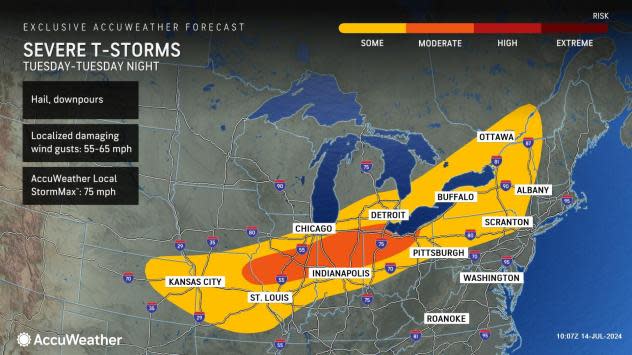
On Tuesday the risk of severe thunderstorms will begin to organize along a slowly advancing push of cooler and less humid air from northeastern Kansas to New York. Chicago, Detroit, St. Louis, Indianapolis, Pittsburgh, Buffalo, New York, and Kansas City, Missouri, are among the major cities at risk for severe weather from Tuesday to Tuesday night.
 |
Where the storms organize into an intense line, power outages may ramp up. Occasionally, severe thunderstorms can produce brief tornadoes, even in situations where the weather pattern does not support widespread tornado activity.
Those with outdoor plans, such as attending fairs, concerts and barbecues, should closely monitor weather conditions where thunderstorms are in the forecast. Even though conditions may be quiet at the start of the event, the weather can change quickly as storms approach. Expert advice for those outdoors is to seek shelter at the first rumble of thunder.
Where heavy rain falls for several hours or downpours repeat over multiple days, stream and river flooding can occur or the recession of some rivers may be delayed.
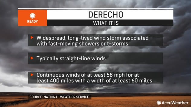
In rare cases, some thunderstorm complexes can evolve into a derecho. These violent thunderstorm complexes produce wind gusts of 58 mph or greater nearly continuously for at least 400 miles. In the past, such as on Aug. 10-20, 2020, in the Midwest, derechos can lead to considerable property, tree and crop damage.
 |
In most cases, a derecho is not officially declared until the system has already covered the distance and most of the wind incidents have been verified. AccuWeather's long-range team of meteorologists warned earlier this year of the potential for long-lived thunderstorm complexes in the Central states during the middle part of the summer.
Want next-level safety, ad-free? Unlock advanced, hyperlocal severe weather alerts when you subscribe to Premium+ on the AccuWeather app. AccuWeather Alerts™ are prompted by our expert meteorologists who monitor and analyze dangerous weather risks 24/7 to keep you and your family safer.
