
Severe storms to fire over High Plains, Upper Midwest through first days of June


Severe weather focused across the High Plains into Saturday night before expanding to the Upper Midwest by later Sunday, then reload over the High Plains and Rockies and advance into the Midwest again early this week. AccuWeather meteorologists warn that more storms packing tornadoes and big hail will continue to pose risks to lives and property.
Areas of severe thunderstorms will shift back and forth from near the Rocky Mountains to the Mississippi River through the middle of this week.
 |
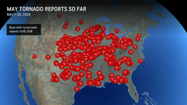
May typically brings a strong surge in severe weather across the United States. However, storm activity this past month has propelled the tally to well above the historical average since 2010, according to the Storm Prediction Center.
There have been more than 500 preliminary reports of tornadoes during May, which is part of more than 6,000 preliminary reports of severe weather.
 |
Of the hundreds of tornado reports, there have been more than 1,800 reports of hail 1 inch or greater and over 350 hail incidents of 2 inches in diameter or larger.
Following a large complex of severe thunderstorms into Friday morning that caused power outages for hundreds of thousands in Texas for the second time this week, the risk of severe thunderstorms returned Friday afternoon and night.
Severe thunderstorms rolled through the southern and central High Plains, bringing numerous reports of large hail and damaging wind gusts. In addition, a line of severe thunderstorms moved through Lubbock, Texas, Friday night, producing wind gusts as high as 90 mph.
The risk of severe thunderstorms returned on Saturday, this time bringing reports of large hail and damaging wind gusts from southwestern South Dakota to West Texas, as well as around East Texas and Louisiana.
 |
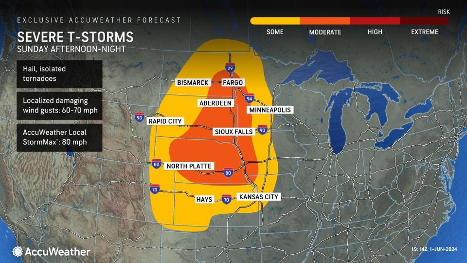
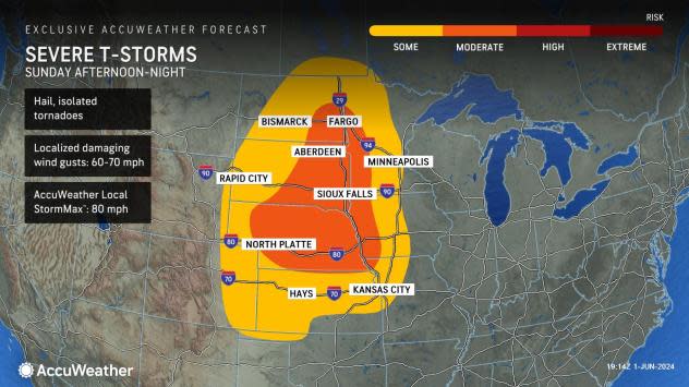
Buckingham said that on Sunday, the threat of severe weather may be toned down some over the High Plains but will most definitely shift northeastward to portions of the northern Plains and part of the Upper Midwest as a storm system races out of the Rockies.
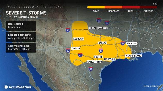
"The severe weather from Sunday to Sunday night will extend from west Texas northward to much of North Dakota and Minnesota," AccuWeather Meteorologist Brandon Buckingham explained. "The main threats from these storms will be high winds, hail and flash flooding."
A tornado or two also cannot be ruled out, mainly over the Upper Midwest.
 |
From Sunday to Sunday night, there will also be some risk for severe thunderstorms across much of western, northern and eastern Texas and Oklahoma, as well as a portion of southwest Arkansas and Louisiana. For storms that develop in this zone, there can be locally damaging wind gusts between 60-70 mph with the AccuWeather Local StormMax™ of 80 mph.
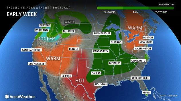
On Monday, AccuWeather meteorologists will closely monitor the potential for severe weather in portions of the northern Rockies and High Plains as an unusually strong storm for early June pushes inland across the Northwest states. These storms will likely bring strong wind gusts, hail and flooding downpours as they track across the Mississippi Valley.
 |
On Monday, further to the east, a mosaic of showers and thunderstorms will extend from the central Gulf Coast to the Great Lakes region. While any thunderstorm in this zone can be locally heavy and gusty, severe weather will likely be limited to portions of the Central Plains and the Mississippi Valley.
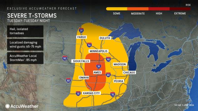
On Tuesday and Tuesday night, there is the potential for an outbreak of severe weather, including tornadoes, for a portion of the northern and central Plains and Upper Midwest. At the very least, multiple storms packing high winds, hail and torrential downpours will extend from eastern and central Oklahoma and western Arkansas northward to the eastern part of the Dakotas, much of Minnesota, central Wisconsin and northwest Illinois.
 |
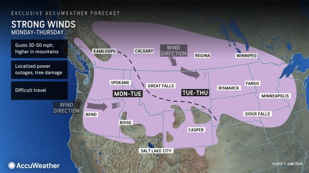
West of the severe thunderstorm activity, howling winds will usher in much cooler air from the northern Rockies to the northern High Plains. Winds may be strong enough in this zone to knock over trees, break large tree limbs and trigger power outages. Where winds blow across the highways, there will be the potential for high-profile vehicles such as trucks and campers to be blown over.
In areas where brush remains dry due to ongoing drought conditions in parts of Montana and the Dakotas, the strong winds will also pose a risk of rapid wildfire breakout and spread.
 |
Want next-level safety, ad-free? Unlock advanced, hyperlocal severe weather alerts when you subscribe to Premium+ on the AccuWeather app. AccuWeather Alerts™ are prompted by our expert meteorologists who monitor and analyze dangerous weather risks 24/7 to keep you and your family safer.
