
Severe storms to target Plains states through the weekend

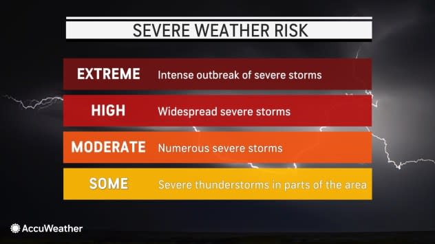


Severe weather will focus on the Great Plains of the United States into Friday night, but while the number of tornadoes may be low, the storms will continue to pose a risk to lives and property, AccuWeather meteorologists warn.
The main effects from the storms will be high wind gusts, hail and torrential downpours that may trigger localized flash flooding. Only a handful of the strongest storms may produce a brief tornado.
 |
A large wedge of cool, dry air will generally suppress large-scale severe weather activity from the Mississippi River to the Atlantic coast for the rest of the week and perhaps right through the weekend, with a few small-scale exceptions.
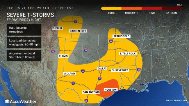
On Friday, much of the risk of severe weather will shift to the east and away from most of the High Plains to the lower-elevation areas of the southern Plains.
Friday's severe weather will most likely extend from central and southeastern Texas to southeastern Kansas and southwestern Missouri.
 |
The Houston area is of particular concern, as a concentrated area of severe thunderstorms was approaching the city as of Friday morning. A large 'bowing' line of storms was pushing southeastward into the region at the start of the day. When a complex of storms takes on this configuration, it often brings high-velocity wind gusts. The AccuWeather Local StormMax™ for Friday's storms is 80 mph, which is the strength of a Category 1 hurricane. Torrential rain and flash urban flooding will accompany the storms. As a result, the morning commute could be difficult and dangerous until the storms pass. The storms have prompted ground stops at the airports. More than 200,000 homes and businesses were without power in the wake of the storms in Texas, according to PowerOutage.us.
A second pocket of late-day storms will likely erupt over the southern High Plains from northwest Texas and northeastern New Mexico to western Kansas and eastern Colorado. Only a few severe storms may erupt in this more western zone.
 |
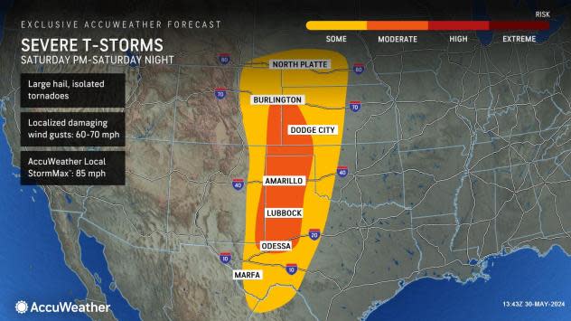
"On Saturday, the likelihood of heavy, gusty thunderstorms and the potential for severe weather will likely again reset farther to the west over the High Plains," Douty said. "AccuWeather will upgrade the potential for severe thunderstorms as warranted."
As a disturbance moves eastward from the Rockies, this time from the northern part of the Rockies, the likelihood of locally severe thunderstorms will extend from western Kansas to the Dakotas and western Minnesota.
Once again, the main threats on Sunday will be high wind gusts, large hail and localized flash flooding.
 |
Because the storms will tend to dwell and fire again over much of the same zones each day through the weekend, where the downpours repeat, the potential for flash flooding of small streams and significant rises on rivers will also increase.
 |
The region at greatest risk for stream and river flooding will include familiar territory in central and northeastern Texas and western Louisiana. From mid-April to mid-May, much of this area received two to three times its normal rain, with double-digit rainfall in some locations, which sent streams, rivers and bayous to major flood stage.
The risk of flooding on a regional basis will extend northward through much of Oklahoma, western Arkansas and eastern Kansas.
 |
However, much of the central U.S. will be at risk for at least localized incidents of flash flooding this weekend as moisture from the Gulf of Mexico escalates over the region and triggers showers and heavier thunderstorms.
Want next-level safety, ad-free? Unlock advanced, hyperlocal severe weather alerts when you subscribe to Premium+ on the AccuWeather app. AccuWeather Alerts™ are prompted by our expert meteorologists who monitor and analyze dangerous weather risks 24/7 to keep you and your family safer.
