
Severe weather, heavy rain will keep blasting the South and East into the weekend

The unrelenting weather pattern of coast-to-coast storms will generate yet another round of heavy rain and severe thunderstorms in the southern and eastern United States into the weekend, threatening to produce damage and flooding, AccuWeather meteorologists warn.
The new round of hazards will come on the heels of damaging storms and nearly two dozen reports of tornadoes in the South Monday and Tuesday, as well as major flooding that spread across portions of the East from last Tuesday to early Wednesday. Another storm late in the week and into the weekend will lead to a repeat performance of the adverse weather conditions in many of the same areas.
In the panhandle of the Sunshine State, there were numerous reports of structural damage during Tuesday morning, including around Panama City Beach. Near Blue Mountain Beach, located about 110 miles west of Tallahassee, a weather station clocked a wind gust of 106 mph, possibly from a tornado.
During the midday hours on Tuesday, a powerful line of thunderstorms advanced into the state of Georgia, and even triggered a tornado warning in Atlanta for a time, though no tornado was confirmed. That same line of storms, and additional ones that developed ahead of it, kept the risk for severe weather and tornadoes high from Florida to the eastern Carolinas into Tuesday night.
Up to several inches of rain in what has already been a wet stretch since the late fall pushed area streams out of their banks and onto roads and into neighborhoods in Georgia and the Carolinas.
The ongoing storminess will cause significant disruptions to daily life and commerce from the Gulf Coast to New England in the form of travel delays, power outages, potential closures of schools and businesses, and possible evacuations of those living near flooded waterways.
There will be no rest for the weather-weary into the early part of the weekend as yet another powerhouse storm crosses the country. AccuWeather warns that many of the same areas that experienced severe weather early in the week will again be dealing with potentially damaging storms to end the week.
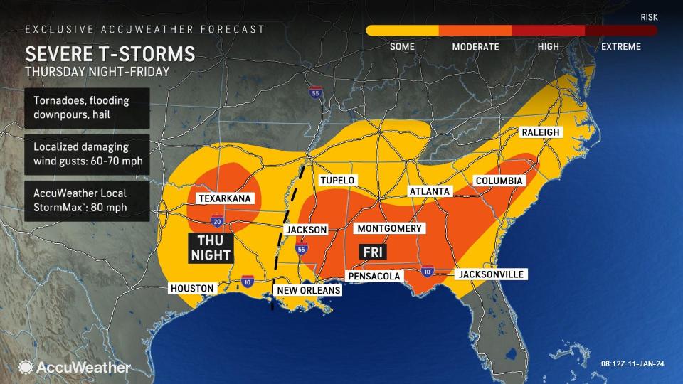
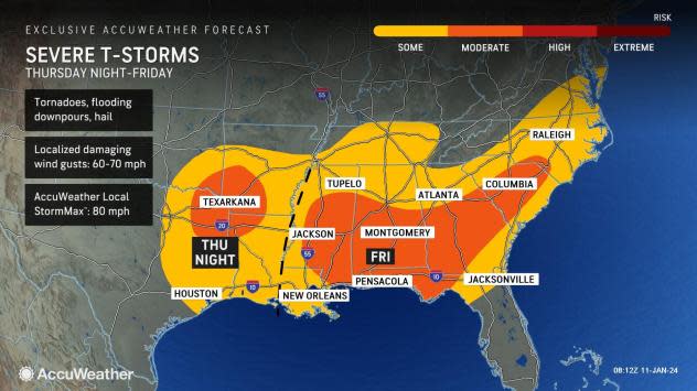
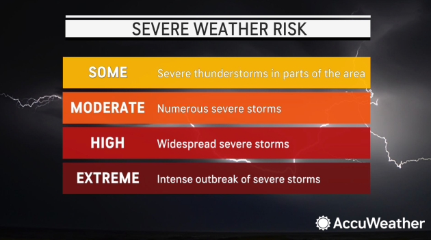
"There will be another threat for severe storms over the Gulf Coast Thursday night into Friday evening with the next storm," said AccuWeather Meteorologist Elizabeth Danco. "Flooding rainfall and hail can occur with any of these thunderstorms."
 |
In any situation during which storms can turn severe and potentially spawn tornadoes after dark, it is crucial to have a way to get warnings overnight, such as via alerts on the AccuWeather App. If a tornado warning is issued, it means that a twister is imminent or is already occurring, and experts recommend quick action to move to a basement or interior room on the lowest floor of your home or business until the tornado threat has passed.
Residents and businesses in AccuWeather's forecast moderate risk zone for the next round of storms, from Louisiana to Georgia, should be especially alert. New Orleans; Montgomery, Alabama; and Pensacola, Florida, are included in this threat area to end the week.
 |
With much of that zone having already dealt with severe weather and even damage from the first round of storms, the second round could exacerbate the cleanup, and make a desperate situation even more dire.
Even in areas that do not experience severe thunderstorms, nearly everyone in the region will have to endure heavy rain once again. Additional rainfall amounts of another inch or two, often falling in less than an hour's time, can lead to flash flooding and push some smaller creeks and streams out of their banks.
 |
Early next week, another round of heavy rain and thunderstorms is possible, as yet another storm could form and move through the South.
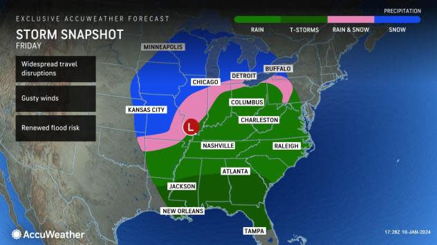
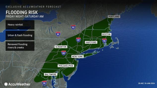
Even though severe thunderstorms are not expected to be a concern in the Appalachians, mid-Atlantic and Northeast into the weekend with either storm, the risk for flooding will be significant. AccuWeather meteorologists are sounding the warning bells about the potential for major flooding in this region, which can persist even after the last raindrops have fallen.
"Yet another round of heavy rain can impact portions of the mid-Atlantic and New England late Friday into Saturday," said Danco. "Given how many rounds of rain, as well as snowmelt this region has experienced recently, it will not take as much rain to raise concerns of flooding."
 |
Following 2-5 inches of rain from Tuesday afternoon through Wednesday morning, another 1-3 inches of rain is possible this weekend. Flooding of all modes-from flash to low-lying to poor drainage to river, creek and stream-is expected to be an issue into the upcoming weekend and beyond.
Larger rivers can flood up to a week or two after the heavy rain moves out as water drains from smaller to larger tributaries. This could force the evacuation of homes and businesses near the banks of these rivers. In addition, following snow in the area this past weekend and early this week, any places that then receive heavy rain could potentially have to deal with roof failures from the weight of the rain being absorbed into the snowpack.
The same storm is poised to bring a dangerous blizzard and rapid freeze-up to the Midwest from Friday to Saturday. Widespread travel disruptions are likely due to stuck vehicles on the roads and stranded airline passengers at the airports due to the likelihood of more than 1,000 flight cancellations nationwide. Chicago is likely to be hit especially hard by the storm.
A major Arctic outbreak is in the offing late in the weekend and into the start of next week, opening up a new set of issues for the storm-weary region, including dramatically lower temperatures.
Want next-level safety, ad-free? Unlock advanced, hyperlocal severe weather alerts when you subscribe to Premium+ on the AccuWeather app. AccuWeather Alerts™ are prompted by our expert meteorologists who monitor and analyze dangerous weather risks 24/7 to keep you and your family safer.
