
Shocking changes coming: Rockies to endure dramatic temperature plunge, mountain snow

A potent storm tracking across the Rockies this week will bring a dramatic drop in temperatures in its wake, and even accumulating snow, according to AccuWeather meteorologists.
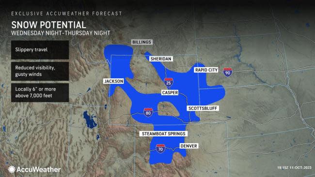
The wintry weather behind the storm that impacted the region through Thursday night can affect travel in the region, leading to slippery conditions, reduced visibility and the formation of ice on some roads and sidewalks.
"The same storm bringing a major cooldown to the West Coast already this week is expected to trek across the rest of the country into the weekend, bringing a range of impacts including rain and even some snow in the higher elevations of the Rockies," AccuWeather Senior Meteorologist Courtney Travis said.
 |
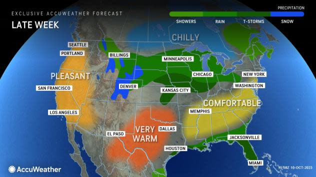
Many will experience weather whiplash across the Rockies, as dramatic temperature plunges can occur into the late week as cold air is ushered in behind the storm.
Temperatures across Colorado and Wyoming have been 2 to 4 degrees Fahrenheit above historical averages so far in October. Denver recorded a high temperature of 80 degrees Tuesday, which was 12 degrees above the historical average for the date.
By Thursday, cooler air combining with clouds and precipitation limited the high in Denver to just 60, with many temperatures across the region in the 40s and 50s and some locations experiencing highs just in the 30s. Temperatures will continue on a downward trend through Friday. Nighttime temperatures will dip into the 20s and 30s into the weekend leading to icy spots on roads and sidewalks.
Have the app? Unlock AccuWeather Alerts™ with Premium+
Forecasters say that those with any outdoor plans through Friday should prepare for chilly conditions. Individuals are urged to bundle up and know the signs of hypothermia while spending time outdoors.
As the cold air advanced, rain transitioned to snow across higher elevations of the Rockies on Thursday, as AccuWeather meteorologists accurately predicted.
For some in the Rockies, this was the first measurable snow since this past April. For example, before Thursday's unofficial total of 2.4 inches of snow in Casper, Wyoming, which sits on the edge of the Rockies and the High Plains, that area had last experienced snow on April 15, when 1.3 inches of snow was recorded. Measurable snow is defined as at least 0.1 of an inch of accumulation.
Motorists are urged to be cautious of changing road conditions, especially through mountain passes. Meanwhile, any remaining snow falling outside the higher terrain will mainly accumulate on non-paved surfaces.
As the storm continues to trek across the country, drenching rain and cooler air will spread into the Plains and Northeast late this week into the weekend, leading to the threat of severe weather, dangerous crosswinds and flooding.
Want next-level safety, ad-free? Unlock advanced, hyperlocal severe weather alerts when you subscribe to Premium+ on the AccuWeather app. AccuWeather Alerts™ are prompted by our expert meteorologists who monitor and analyze dangerous weather risks 24/7 to keep you and your family safer.
