
Snow, cold winds to follow rainstorm in Northeast


A massive storm tracking toward the East Coast, packing torrential downpours and severe thunderstorms, will have one more trick up its sleeve before exiting the country early this week-a transition to snow and chilly winds for portions of the Northeast, warn AccuWeather meteorologists.
The threat of travel delays from slushy roads across the Appalachians, the eastern Great Lakes and a large swath of the interior Northeast through early Monday will follow unseasonably mild conditions and a soaking rain. Just enough cold air will arrive before the precipitation ends to cause a changeover to snow, which can accumulate several inches across portions of about a dozen states from Tennessee to Maine.
"As cold air surges in on the back side of a powerful storm, heavy rain is expected to transition to heavy snow quickly," AccuWeather Meteorologist Brandon Buckingham said.
The setup is somewhat of a rare one; unlike most storms, precipitation is expected to linger behind the cold front as it sweeps through, which will result in the changeover to accumulating snow across the region's interior. The timing of the front, the exact temperatures and how much precipitation lingers will all determine the severity of wintry conditions.
"Even in areas that receive little in the way of snow, there will be a quick change to colder air behind the front through Monday morning," said AccuWeather Senior Meteorologist Dan Pydynowski. "Because of that, wet areas on untreated roads and sidewalks can quickly become icy and impact the Monday morning commute in cities such as Pittsburgh, Youngstown and Akron."
 |
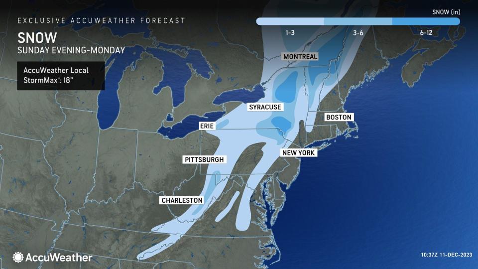
Total accumulations of 1-3 inches, with pockets of plowable snow up to half a foot, are expected from southwestern New York through west-central Pennsylvania, much of eastern West Virginia, the spines of the Blue Ridge Mountains in Virginia and down through the Smokies.
The zone of greatest concern for more severe wintry weather impacts will be from northern Pennsylvania through interior New England through Monday morning.
"A corridor of heavy snow is expected to set up from upstate New York and into Vermont and northern New Hampshire," said Buckingham. "Even though the ground here will be soaked by heavy rain earlier in the day, intense snowfall rates can quickly cover grassy surfaces and some roadways."
Many places in this corridor will receive 3-6 inches of snow accumulation, with 6-12 inches possible in the Catskills, Adirondacks and the higher terrain in far northern Vermont and New Hampshire. The AccuWeather Local StormMax™ for snow in this area is 18 inches. As Buckingham mentioned, intense snowfall rates-perhaps an inch or two per hour-can make for dangerous travel conditions that may even persist into the Monday morning commute.
Strong winds will accompany the snow as the storm intensifies rapidly while moving north and east through Monday. Wind gusts between 40 and 50 mph can occur in some of the area where rain changes to snow and could even be in the range of 50-60 mph across coastal New England. A corridor from Long Island, southeastern Massachusetts and Cape Cod into coastal Maine and Nova Scotia can face peak gusts of 60-70 mph at times. Winds combined with snow can reduce visibility to near zero and make travel extremely hazardous, even in four-wheel drive vehicles.
Along the Interstate 95 corridor and the coastal plain of the Northeast, it will be too warm for the rain to end as snow, even factoring in a sharp drop in temperature. Instead, torrential downpours and locally damaging winds will impact travel through through Monday from the nation's capital through Philadelphia, New York and Boston.
Farther inland, the dramatic drop in temperature will be jarring.
"High temperatures in places like Pittsburgh and Syracuse that were in the 50s and 60s during the day on Sunday, will be replaced by the mid-30s by Monday," added Buckingham. "Factoring in the blustery wind, AccuWeather RealFeel® Temperatures can be as much as 20 degrees [lower] than what the actual air temperature is."
That chilly air blowing over the relatively warm Great Lakes will also result in some lake-effect snow showers behind the storm from Monday through early Tuesday morning. This can lead to slippery travel lasting longer over parts of northeastern Ohio, northwestern Pennsylvania and western New York.
 |
Strong high pressure following the storm will lead to dry and much quieter weather conditions for the remainder of next week from the nation's heartland to the Atlantic coast.
Want next-level safety, ad-free? Unlock advanced, hyperlocal severe weather alerts when you subscribe to Premium+ on the AccuWeather app. AccuWeather Alerts™ are prompted by our expert meteorologists who monitor and analyze dangerous weather risks 24/7 to keep you and your family safer.
