
New snowstorm to blanket areas from Chicago to Pittsburgh, DC and NYC


A two-part storm will spread accumulating snow and travel disruptions across 18 states in the Midwest and Northeast, home to 115 million people, into Friday night, AccuWeather meteorologists warn. Arctic air will pour in following the storm, resulting in the coldest winter weekend so far for much of the eastern United States.
Even though a blockbuster snowfall is not anticipated for the region, the different parts of the storm will hit some areas harder than others.
 |
"This will be a colder storm than most have grown accustomed to in much of the Midwest and the Northeast in that the lower ground and air temperatures combined with the fluffy or grainy nature of the snow will quickly accumulate on streets and highways," AccuWeather Senior Meteorologist Brett Anderson said.
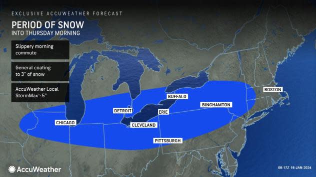
The first and weaker part of the storm will focus the farthest north of the two portions -- along the Interstate 80 and 90 corridors of the Midwest and Northeast.
 |
"Snow from eastern Iowa, northern Illinois and southern Wisconsin to much of New York state, northern New Jersey and southern New England will bring a general coating to 3 inches of accumulation with locally higher amounts," AccuWeather Chief On-Air Meteorologist Bernie Rayno said.
This quick-moving streak of light snow will continue into Thursday morning. This part of the storm has the best chance of bringing a couple of inches to Chicago, Detroit and Buffalo, New York. Motorists should be prepared for delays on the highways and at airports. Some flights may be canceled.
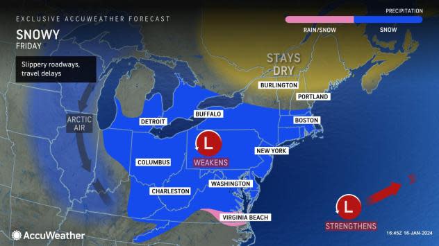
The second part of the storm will be stronger and will waste no time sweeping eastward, likely extending farther south than the first part and bringing widespread snowfall ranging from very light to moderately heavy.
 |
Only a small amount of snow may fall on Chicago from the second part of the storm during Thursday afternoon and night, and there is a chance that accumulating snow may stay south of Boston on Friday.
However, accumulating snow is in store for much of the I-80, I-70 and I-64 corridors, beginning Thursday afternoon and evening in the Midwest and extending to the central Appalachians during Thursday night and the mid-Atlantic by Friday.
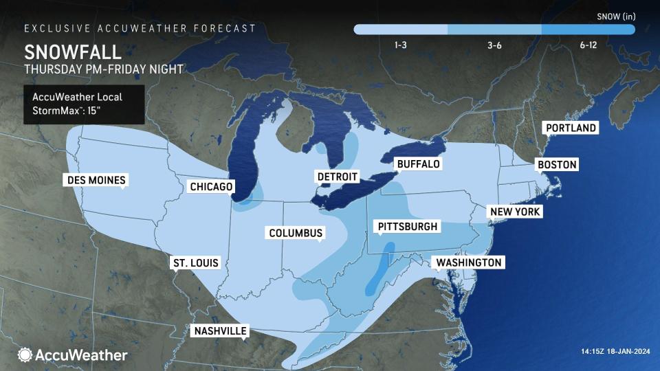
A general 1-3 inches of snow is forecast to fall from Iowa to the mid-Atlantic and southern New England. Within this area, 3-6 inches of snow is predicted to pile up in an area centered on parts of Ohio, Pennsylvania, West Virginia, eastern Kentucky, northern Maryland and central New Jersey.
 |
The area most likely to pick up a foot of snow and the AccuWeather Local StormMax™ of 15 inches is the mountains of West Virginia.
This area of moderate to heavy snow may extend into southern New Jersey and Delaware, which would put a plowable snowstorm in play for Washington, D.C.; Baltimore; Philadelphia, Pittsburgh; Cleveland; and Charleston, West Virginia. Enough snow to shovel and plow could extend to Cincinnati, Atlantic City, New Jersey; and Dover, Delaware.
 |
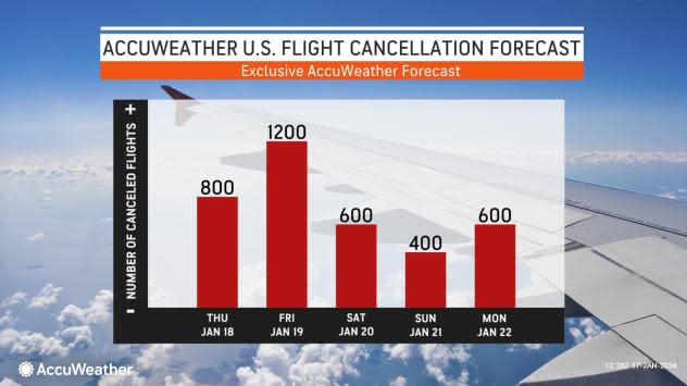
Regardless of the exact amount of snow that falls, roads will be slippery and snow-covered in many cases. Deicing operations will be in full swing at most of the major and regional hubs in the Midwest and Northeast on Friday and Friday night. That will escalate to high numbers of flight delays and cancellations.
Around New York City, another general 1-3 inches of snow is in store on Friday, with higher totals not out of the question for Staten Island and southern parts of Brooklyn and Queens. Boston is likely to end up near the northern edge of the accumulating snow.
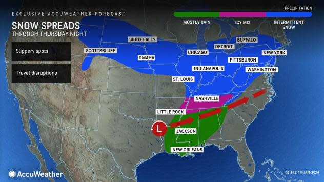
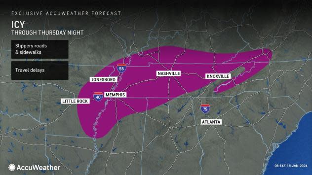
Farther to the south, a zone of wintry mix or ice will extend from central Arkansas and northern Mississippi to part of the southern Appalachians in Tennessee, southeastern Kentucky and western North Carolina from Thursday to Thursday night.
 |
Even a small amount of ice or a wintry mix can lead to dangerous travel. To make matters worse, the frigid air after the storm will cause a hard freeze-up.
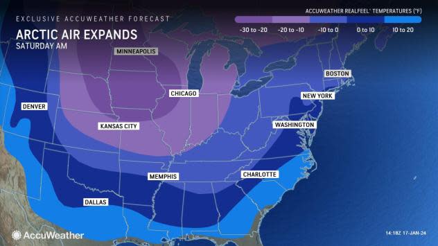
The Arctic air coming in behind the storm means business and will likely deliver the lowest temperatures of the winter so far in the East, especially from the mid-Atlantic to the Southeast region.
 |
The snow and frigid temperatures during and after the storm will have skiing enthusiasts jumping for joy for the weekend, but anyone spending time outdoors will need to bundle up due to the risk of hypothermia and frostbite.
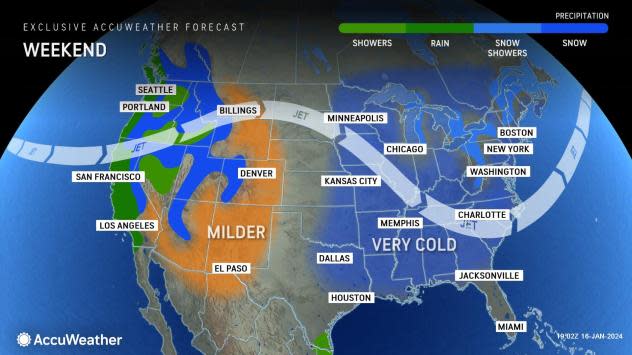
Motorists and pedestrians should keep in mind that plunging temperatures in the wake of the storm from Friday night to Saturday will cause areas of slush and standing water to freeze. Road and storm cleanup crews may stay busy after the storm moves away this weekend, especially around the Great Lakes, where more heavy snow will pile up due to the lake effect.
 |
"This light, fluffy snow will also be easily blown around by gusty winds, especially from Friday night to Saturday," Anderson said. "The visibility may suddenly drop, and previously treated or plowed roadways, sidewalks and parking lots may become blocked and slippery again."
Temperatures will drop into the teens from Philadelphia and Washington, D.C., to Charlotte, Atlanta and Columbia, South Carolina, at night this weekend. Where there are a few inches of snow on the ground, the sky becomes clear and the winds drop off, temperatures could plummet into the single digits and even approach zero F.
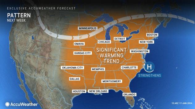
For those thinking of warmer days, temperatures are projected to rebound slowly next week, but beware of the look of blissful warmth.
 |
As is often the case when storms are involved, there will likely be areas of travel-snarling fog and ice to contend with in parts of the Midwest, Appalachians and Eastern Seaboard as moisture from the Gulf of Mexico and the Atlantic Ocean returns with the trend.
Want next-level safety, ad-free? Unlock advanced, hyperlocal severe weather alerts when you subscribe to Premium+ on the AccuWeather app. AccuWeather Alerts™ are prompted by our expert meteorologists who monitor and analyze dangerous weather risks 24/7 to keep you and your family safer.
