
Southern US storms could spawn isolated tornadoes, waterspouts through the end of the weekend


A storm system swinging eastward along the Gulf coast states through Monday will spark the threat of intense rainfall, severe weather and travel impacts.
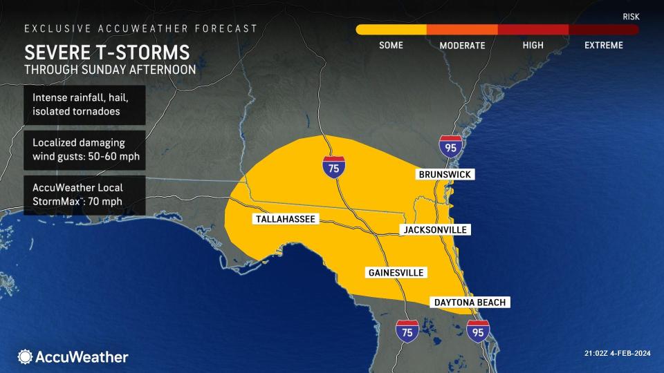
AccuWeather forecasters warn that as this feature barrels through the Southeastern states through the end of the weekend, rounds of strong to severe thunderstorms can erupt across a portion of the Florida Peninsula putting residents at risk for intense rainfall and isolated tornadoes from Jacksonville to Orlando.
As the center of the storm advances across Florida through Sunday night, the swath of rain and thunderstorms will spread across the region. Flooding issues can develop as many areas collect between 1-2 inches of rainfall through the end of the weekend, with locally higher amounts possible in thunderstorms.
Floridians enjoyed a nice start to the weekend on Saturday, but will saw a noticeable shift in the weather by Sunday morning. A zone of high pressure that promoted dry weather and sunny skies at the start of the weekend has departed the region and has been replaced by a moisture-ridden storm. In cities like Orlando and Jacksonville, daytime temperatures declined by 3-6 degrees Fahrenheit from Saturday to Sunday.
 |
Forecasters say that after the initial round of storms that pushed through the region Sunday morning, there can be another rounds of intense thunderstorms associated with the progression of the storm by Sunday afternoon.
"An initial wave of storms can develop during the morning in Florida, then things can clear out for a few hours and destabilize before another round of storms ignite throughout the afternoon," noted AccuWeather Senior Meteorologist Adam Douty.
In Miami, a wind gust of 67 mph was reported on Sunday morning as storms rolled through. Early Sunday afternoon, storms with rotation signatures began popping up around locations east of Tallahassee, Florida, prompting a tornado warning.
Winds from Alabama to South Carolina will pick up later this weekend, with gusts increasing to up to 25-30 mph. In strong to severe thunderstorms, locally damaging winds across the Florida Peninsula can even reach speeds of 50-60 mph with the AccuWeather Local StormMax™ of 70 mph.
In addition to the locally damaging winds, AccuWeather forecasters also warn that this storm setup could be conducive for the formation of isolated tornadoes and waterspouts.
"Residents along the coast of Florida will have to be cautious of waterspouts moving onshore. These can develop rapidly with little warning time, it is always important to have a severe weather plan in place," explained AccuWeather meteorologist Alex DaSilva.
 |
DaSilva added that the hail threat across central Florida will not be non-zero on Sunday as thunderstorms advance across the state. However, hailstones with diameters greater than 1-inch will not be as likely in this zone as small hail.
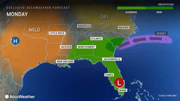
Periods of rain and thunderstorms will persist into the overnight hours on Sunday across the Southeast, further elevating the risk for flash flooding. By Monday morning, the center of the storm will shift off the east coast of Florida and while continuing to spread pockets of moisture to parts of Florida, Alabama, Georgia and South Carolina.
Rain and showers will linger from southern Mississippi to South Carolina as the storm gradually tracks eastward. By Monday evening, the only locations that may still face impacts from the storm may be locations directly along the coast of eastern Florida.
Have the app? Unlock AccuWeather Alerts™ with Premium+
Although, by Monday evening any remaining showers can be light in nature. The primary impacts that will linger the longest will be the gusty winds across the Southeast, which can ramp up throughout the day on Monday from the Carolinas to eastern Florida.
 |
High pressure is on track to return by Tuesday across the Mississippi and Tennessee Valleys, which will promote warmer conditions and plenty of sunshine. A few showers and clouds can impact far southeastern Florida on Tuesday, but the majority of the state can expect drier conditions compared to the end of the weekend.
The dry conditions will persist across the Southeast into late week, but a cold front can approach the region by late Thursday and bring another round of rain to the Gulf Coast states.
Want next-level safety, ad-free? Unlock advanced, hyperlocal severe weather alerts when you subscribe to Premium+ on the AccuWeather app. AccuWeather Alerts™ are prompted by our expert meteorologists who monitor and analyze dangerous weather risks 24/7 to keep you and your family safer.
