
Surge of summerlike warmth and humidity across the Northeast on the way


Northeast residents are in for toasty start to the week, AccuWeather meteorologists say. A stretch of drier weather and rising temperatures are expected to grip areas from the Ohio Valley to the mid-Atlantic and New England into midweek for many.
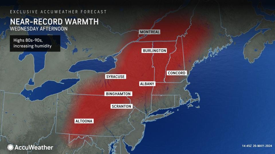
Through Wednesday, a pronounced northward bulge in the jet stream over then Eastern United States will help to usher in a zone of high pressure. This feature will promote a surge of warmth from cities like Charlotte, North Carolina, to Bangor, Maine, where temperatures will rise in to the upper 80s Fahrenheit by mid- to late week.
 |
Daytime temperatures at times this week will range into the 90s F for locations across New York state, like Syracuse and Albany. Most cities and towns across the mid-Atlantic and Northeast will observe temperatures rising between 8-16 degrees F above typical mid- to late-May values, and several degrees higher than highs that were observed over the weekend.
Have the app? Unlock AccuWeather Alerts™ with Premium+
"Temperatures by midweek [across the Northeast] will reach levels typically experienced in the middle of summer," noted AccuWeather Meteorologist Adam Sadvary.
One note of caution for residents getting outside to enjoy the dry, warm setup early this week and flocking to bodies of water is that most lake water temperatures are still generally between 50 and 60 degrees F, with only a few locations rising to around 70 F at this time.
Experts warn that any water temperatures below 70 degrees F should be treated with caution. Below this value, the human respiration can begin to be adversely affected.
 |
Not only will conditions progressively turn warmer into midweek, but forecasters also note that humidity levels are also projected to rise from midweek to late week.
"As high pressure makes its way offshore over the Atlantic by the middle of the week, even warmer and more humid air will flow into region from out of the south," explained Sadvary.
Dew points will climb into the 60s F across a large portion of the mid-Atlantic states and Northeast coastline. Directly ahead of a cold front expected to pulse across the Ohio Valley and Great Lakes into the Northeast from Wednesday to Thursday, dew points can even rise into the upper 70s F.
 |
Sadvary added that with the increase in humidity, AccuWeather RealFeel® Temperatures can also soar into the 90s F by Wednesday and Thursday for some locations.
"If you haven't gotten around to installing your air conditioner units, the start of this week would be an optimal time to do so," Sadvary recommended.
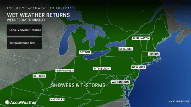
Moisture will return from mid- to late week as a storm tracking across southeastern Canada with a trailing cold front advances across the eastern states. From Wednesday to Wednesday night, pockets of stronger thunderstorms will develop along the front and ramp up across the Ohio Valley. Some storms may even turn severe.
 |
As wet weather returns to the Ohio Valley and interior Northeast around midweek, storms that push into the region will be capable of packing downpours, hail, locally damaging winds and even isolated tornadoes.
Following the handful of tornadoes that touched down in southwest Pennsylvania on Friday, May 17, residents across Allegheny and Westmoreland counties should remain on alert for more potentially disruptive storms.
Once storms advance closer to the Northeast coast later this week, the dry streak will come to an end for cities such as Boston, New York, Washington, D.C. and Philadelphia. The comparatively cooler air mass arriving behind the front will yield slightly cooler conditions, bringing most locations back to highs in the 70s F.
 |
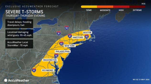
From Thursday to Thursday evening, storms that develop along the Northeast coast will have the potential to turn severe. Hazards such as gusty winds, flooding downpours and hail can arise in the strongest storms.
Commuters from late Thursday afternoon to evening should remain aware of the ongoing weather in the area and prepare for potential travel disruptions.
Want next-level safety, ad-free? Unlock advanced, hyperlocal severe weather alerts when you subscribe to Premium+ on the AccuWeather app. AccuWeather Alerts™ are prompted by our expert meteorologists who monitor and analyze dangerous weather risks 24/7 to keep you and your family safer.
