
Tornado watch - live: Two dead in Alabama as storms tear through South leaving thousands without power
The “threat for supercells capable of all severe hazards” continued into Wednesday morning, forecasters said, after tornadoes and severe weather tore through much of the southern US overnight on Tuesday and into Wednesday morning.
At least two people were killed in Montgomery, Alabama, the state’s director of emergency management said, noting that there could be more as search-and-rescue crews began checking on residents and surveying the damage on Wednesday.
“They were in their home that was struck by a tree due to the tornado,” said Christina Thornton.
Parts of Mississippi, Alabama, Arkansas, Louisiana, and Tennessee faced at least 17 tornadoes as well as severe flooding and tennis ball-sized hailstones as warnings continued in Alabama into Wednesday morning.
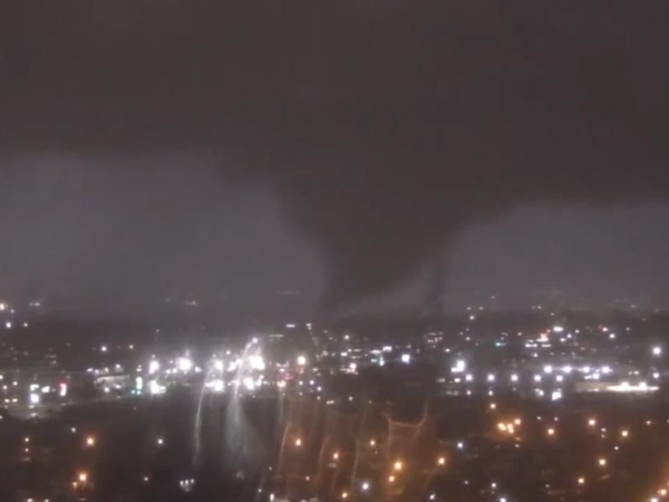
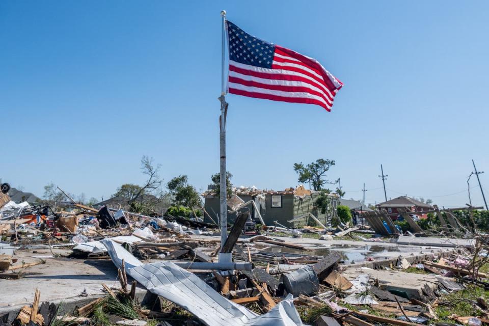
Images and videos of the aftermath of tornadoes showed damaged houses and fallen trees, while injuries began being reported in states like Mississippi and Louisiana.
High winds downed power lines leaving more than 50,000 customers in Mississippi and Alabama without electricity Wednesday morning, according to poweroutage.us.
Threats from the storms were expected to persist through early Wednesday morning. Later today the storm system is forecast to move east.
Key Points
Multiple tornadoes touched down across Mississippi and Louisiana
At least two killed from tornadoes in Alabama
At least a dozen Mississippi homes, buildings suffer significant damage
Flights across the US are delayed and cancelled
Storms cause major tornadoes, flooding across South
Six people trapped by tornado in Mississippi rescued
What is the difference between a tornado watch and a warning?
15:31 , Johanna Chisholm
As tornadoes and severe storms bore down on much of the southern US on Tuesday, many cities, counties and states began issuing weather warnings, some even tornado warnings.
The incident is just the latest reminder to be prepared for extreme weather events, have a plan in place should an emergency situation arise and to know the difference between a tornado watch and a tornado warning alert when you receive one on your phone.
The former is the preliminary alert issued a few hours in advance of a coming storm, intended to make those likely to be in its path aware of the situation in order to ensure that they keep an eye on developments, remain vigilant and prepare to move should an evacuation prove advisable.
A tornado warning, meanwhile, is more urgent and highly localised and should be regarded as an order to take shelter as soon as possible because the storm’s impact is imminent.
Joe Sommerlad explains it in more detail here.
What is the difference between a tornado watch and a warning?
At least two killed from tornadoes in Alabama
15:07 , Johanna Chisholm
At least two people were confirmed to have been killed in Alabama after a severe storm system tore through much of the southern US with tornadoes leaving a wake of destruction in their path.
“We do not have an exact number and I do not want to give incorrect information, but there are minor, moderate, and obviously, the two fatalities that we have suffered for our community at this point in time. So, that’s where we are right now,” said Christina Thornton, Montgomery County, Alabama Emergency Management Director during an interview with Fox Weather’s Jason Frazer and Britta Merwin on Wednesday morning.
“We’re – like I said, we’re just trying to get the information. They’re still doing search and rescue efforts if they’re able to get to homes due to the trees being down in the roadways.”
Injuries were also confirmed earlier on Wednesday in Mississippi and Louisiana where tornadoes were also reported to have touched down on Tuesday night.
Watch the full interview here.
Dozens of homes in Alabama torn apart by severe storm
15:05 , Johanna Chisholm
In the west Alabama town of Eutaw, video from WBMA-TV from showed large sections of the roof missing from an apartment complex, displacing 15 families in the middle of the night.
“We’ve got power lines, trees just all over the road,” Eutaw Police Chief Tommy Johnson told WBRC-TV. “In the morning when we get a little daylight, we’re going to do a door-by-door search to make sure no one is trapped inside or anything like that.”
Local news reporter Megan Scarano shared heartbreaking footage from the scene on Wednesday morning, noting how the shredded apartment complex provided disturbing views from the hallways straight into people’s bedrooms.
“This is the reality this morning for some families at Sagewood Apartments in Eutaw. Their home torn to shreds. You can see straight through bedrooms and hallways, Siding, shingles, and wood is laying all over their backyard,” tweeted Ms Scarano.
This is the reality this morning for some families at Sagewood Apartments in Eutaw. Their home torn to shreds. You can see straight through bedrooms and hallways, Siding, shingles, and wood is laying all over their backyard.@abc3340 @spann pic.twitter.com/QfO85hRvwL
— Megan Scarano ABC 33/40 (@MScaranoNews) November 30, 2022
Stunning videos from Mississippi show wall of thunder in middle of severe storm
14:45 , Johanna Chisholm
Videos from Tuesday night showed the stunning and severe weather that tore through the southern US, which left many homes damaged and at least a few injuries reported as of early the next day.
A wall of thunder was captured by a storm chaser in Mississippi who caught the shocking footage while driving down the road on Tuesday night.
Continuous lightning as a severe thunderstorm passed through NE Jackson, with a visible wall cloud. #mswx pic.twitter.com/sUEomxVY8R
— Will Day (@wx2day) November 30, 2022
The non-profit organisation Sirens Project, which assists communities in emergency events by deploying volunteers and supplies, captured a harrowing shot of a tornado touching down near Bay Springs, Mississippi on the interstate.
“Thankfully we didn’t discover damage requiring our equipment. Continuing NE to monitor developing supercells into AL,” tweeted the group on Tuesday.
Tornado earlier near Bay Springs, MS as seen from Interstate 59. Thankfully we didn't discover damage requiring our equipment. Continuing NE to monitor developing supercells into AL. #mswx pic.twitter.com/BtKQgvNep1
— Sirens Project, Inc. (@sirensproject) November 30, 2022
Watch: Satellites show 'particularly dangerous' storm in southern US
14:30 , Johanna Chisholm
Satellite footage from this week shows the “particularly dangerous” storm system developing across the southern US.
Watch the clip below here.
Tornadoes confirmed in Mississippi, Alabama on Tuesday
14:15 , Johanna Chisholm
The National Weather Service in Birmingham, Alabama confirmed by radar that a tornado had touched down on Tuesday just southwest of Tallassee, which led the agency to issue a warning to residents to “take cover immediately!”
A tornado has been confirmed by radar just southwest of Tallassee, take cover immediately! pic.twitter.com/FONu8vPcmj
— NWS Birmingham (@NWSBirmingham) November 30, 2022
While in Mississippi, the NWS confirmed that a tornado had hit at around 7.15pm CT in Paulding and Stringer.
CONFIRMED tornado on the ground with this warning. Please seek shelter immediately! https://t.co/ToZnBtQxH3
— NWS Jackson MS (@NWSJacksonMS) November 30, 2022
Major temperature swings in Texas after record-highs set during Tuesday’s storm
14:00 , Johanna Chisholm
Record highs were set in parts of Texas on Tuesday, with meteorologists attributing the warmer than average temperatures to partially fuelling the severe storm system that surged across the southern US.
On Wednesday, however, the forecast had swung in the other direction, with some parts of the state experiencing a 40-degree drop from the day before.
“The temperature roller coaster doesn’t quit over the next week. Record heat yesterday, winter chill today, warm by Friday, cold again this weekend,” tweeted meteorologist Avery Tomasco.
Texas, man...
The temperature roller coaster doesn't quit over the next week. Record heat yesterday, winter chill today, warm by Friday, cold again this weekend...
Please keep hands/feet inside the vehicle at all times #atxwx #txwx pic.twitter.com/6tmD7aRYth— Avery Tomasco (@averytomascowx) November 30, 2022
In cities like Pampa and Canadian, the temperature was nearly 40 degrees colder than it was one day earler.
Check out the swing in temperatures we are seeing this morning compared to this time yesterday! Pampa and Canadian are nearly 40° colder than they were this time yesterday!#txwx #okwx #nmwx #phwx @ABC7Amarillo @StormSearch7 pic.twitter.com/Q2ynvoAbjd
— Corbin Voges WX (@CorbinVogesWX) November 30, 2022
Watch: Drone footage captures tornado touching down in Mississippi
13:55 , Johanna Chisholm
Stunning drone footage captured in Mississippi shows the moment that a tornado touched down just outside of Bassfield at around 5pm.
Twitter user Ryan Hearne shared the video on his personal account on Tuesday night, which showed the dark ominous clouds that soon became the large swirling tornado that swept across the screen.
“Just shot an incredible tornado video just to the southwest of Bassfield, Mississippi at approximately 5 PM using my drone, this is just a short clip but I’ll be releasing a full video later tonight,” tweeted Mr Hearne on Tuesday while sharing a clip of the severe weather.
WATCH: a drone captured an absolutely amazing perspective of a tornado in Bassfield, MS earlier today!
We're LIVE into the night as the heightened tornado threat in the South continues! pic.twitter.com/5hcKPoBjuI— The Weather Channel (@weatherchannel) November 30, 2022
Power lines downed as thousands left without power in Alabama, Mississippi
13:45 , Johanna Chisholm
High winds downed power lines as more than five inches of rain fell within several hours in some parts of the south, leaving more than 50,000 customers in Mississippi and Alabama without electricity Wednesday morning, according to poweroutage.us.
In Alabama, as of 7.30am local time, there were 38,399 customers without power, while in Mississippi, there were more than 7,000 customers left in the dark.
In Louisiana and Texas, which also experienced severe weather on Tuesday night, there was a combined 7,000 customers without electricity.
At least seven to 10 homes in Mississippi severely damaged after tornadoes rip through state
13:30 , Johanna Chisholm
Homeowners in Mississippi began survey the damage that their properties had suffered late Tuesday night after at least two tornadoes touched down in Choctaw and Lowndes counties.
El #TiempoSevero en el sur de #EstadosUnidos continúa esta mañana. Se reportan daños en #Lousiana, #Mississippi y #Alabama.
Al menos dos tornados tocaron tierra en los condados de #Choctaw y #Lowndes, en Mississippi.
Video: @CharlesPeekWX
Síguenos https://t.co/vV0LH8P67p pic.twitter.com/cNqA6U6nZe— Conexión Con El Tiempo (@conexiontiempo) November 30, 2022
Video footage and photos from northeastern Lowndes County showed at least seven to 10 homes with significant damage, and a roof from a fire station was entirely torn off.
Tornado damage earlier tonight in NE Lowndes County, MS. 7-10 homes damaged with a few with substantial damage and the roof torn off the fire station. No injuries reported. Myself and @mikeseidel will be live from here starting at 7:00am (Central) for @weatherchannel. #MSwx pic.twitter.com/TTQycECrgh
— Charles Peek (@CharlesPeekWX) November 30, 2022
Tornado warnings continues in Alabama
13:12 , Johanna Chisholm
The National Weather Service continued to issue a tornado warning for Barbour County, Alabama, which it said would remain in place until 6.45 AM CT.
Tornado Warning continues for Barbour County, AL until 6:45 AM CST pic.twitter.com/iOOSxP02qS
— NWS Tornado (@NWStornado) November 30, 2022
Injuries reported in Montgomery, Alabama
13:05 , Johanna Chisholm
The Montgomery County Emergency Management Agency reports damage with injuries from the storm that pushed through the area, but did not disclose the extent of the injuries or how many people had been hurt.
The damage is to homes and manufactured homes, according to the EMA.
Warmer than average temperatures helped fuel Tuesday’s storm
12:40 , Johanna Chisholm
The National Weather Service in Shreveport, Louisiana reported early Wednesday morning that part of what fuelled Tuesday’s severe weather can be attributed to the warmer than average temperatures experienced across the region.
In Shreveport, located in the northwest part of the state, the city recorded a high of 81 degrees Fahrenheit, while over in Texas, the city of Tyler recorded a high of 82 degrees.
Both broke records of 80 degrees, which had been previously set in 1949.
Record high temps 🌡️ yesterday (11/29/22) helped fuel the severe weather around the region #txwx #lawx
Shreveport reached 81
Tyler reached 82
Both broke records of 80 degrees in 1949.— NWS Shreveport (@NWSShreveport) November 30, 2022
Tornado warnings issued for parts of Alabama
12:26 , Johanna Chisholm
Early morning tornado warnings continued to be issued in parts of Alabama and Texas as millions of residents across the south hunkered down overnight to take shelter from the severe storm system passing through on Tuesday into Wednesday.
The National Weather Service alerted residents in Texasville and Bakerhill, Alabama to take shelter as a warning was issued for the region, expected to last until 6.45am CT.
Tornado Warning including Bakerhill AL and Texasville AL until 6:45 AM CST pic.twitter.com/8LhC3uhExz
— NWS Tornado (@NWStornado) November 30, 2022
Hundreds of flights delayed in the US as dozens more cancelled
12:20 , Johanna Chisholm
Early Wednesday morning, nearly 500 flights within, into or out of the US had been delayed with dozens more cancelled as the storm system theatens to cause further delays and wreck havoc on the South.
In total, there were 493 flights that were delayed and 95 cancelled that were going into, within or out of the US, according to FlightAware.
It was not immediately clear whether those cancellations and delays were all related to the weather system.
Trees down, buildings damaged and injuries reported across the South
11:55 , Johanna Chisholm
In Sumiton, Alabama, located about 25 miles northwest of Birmingham, the fire and rescue team shared pictures late Tuesday night of the damage from the tornadoes and golf ball-sized hail that ripped through the city and wrecked buildings.
While in Caldwell Parish, Louisiana, located about 32 miles south of Monroe, the damage could to people and homes was beginning to make itself clear early in the morning on Wednesday.
According to local news station KNOE, there were already two injuries reported in the area with debris and wreckage piling up on highways.
CALDWELL PARISH UPDATE: We have new photos out of Caldwell Parish, LA near HWY 126. Significant damage has been reported throughout this area and two injuries were also reported. @TylerEnglander will be live on the scene tonight at 10AM, and @jesstorricelli at 5AM. #lawx #mswx pic.twitter.com/rh9wkEQlvh
— Jake Lambright (@jakelambright) November 30, 2022
Major cities included in latest tornado warning include Mobile and Prichard, Alabama
11:30 , Johanna Chisholm
The National Weather Service provided more details about this morning’s tornado warning that was issued across three states, including Georgia, Florida and Alabama.
Cities included in the tornado warning in Alabama, which is valid until 5.45am CT, were Prichard, Chickasaw, Stapleton, Mobile, and Spanish Fort.
Tornado Warning including Mobile AL, Prichard AL and Spanish Fort AL until 5:45 AM CST pic.twitter.com/ndW3Y3lLUF
— NWS Tornado (@NWStornado) November 30, 2022
Tornado watch issued for Alabama, Florida and Georgia
11:13 , Johanna Chisholm
Heavy thunderstorms rolled overnight from eastern Texas to Georgia and as far north as Indiana as new tornado watch has been issued for parts of Alabama, Florida and Georgia this morning.
More than a dozen Alabama counties were under a tornado watch this morning with many areas. The watch is set to last until 11am CT.
A tornado watch has been issued for parts of Alabama, Florida and Georgia until 11 AM CST pic.twitter.com/VfMBLDOJHh
— NWS Tornado (@NWStornado) November 30, 2022
Large cities including New Orleans, Atlanta, Montgomery and Mobile are in the area at risk on Wednesday.
The National Weather Service confirmed that tornados hit the ground in Mississippi yesterday evening and Alabama was in the forecast path of the storms during the overnight hours.
Power down and schools delayed in Hale County, Alabama
09:30 , Stuti Mishra
A tornado has damaged at least 30 houses and knocked out power in part of Hale County, Alabama tonight, according to local media reports.
Rural communities in Akron and Stewart area were hit by a tornado that crossed the Warrior River after causing damages in Eutaw.
AKRON: Mayor tells me at least 4 houses damaged, 50 trees down, and no power on Oak Village Road. Thankfully No injuries. @abc3340
— Megan Scarano ABC 33/40 (@MScaranoNews) November 30, 2022
Several trees and fallen and power lines have been damaged as hundreds of houses remained without electricity.
Threats from the storms were expected to persist through early Wednesday morning. On Wednesday, the storm system is forecast to move east.
Multiple tornadoes touched down across Mississippi and Louisiana
09:00 , Stuti Mishra
At least 17 tornadoes have touched down across Mississippi and Louisiana before midnight, according to the National Oceanic and Atmospheric Administration amid a “particularly dangerous” weather situation in the southern states.
Tornadoes were reported from Bassfield, Bywy, Steens and several other areas in Mississippi downing trees and damaging houses.
Meanwhile in Louisiana, at least two people were injured inside their homes during the storm (see post below).
Dozens of tornado watches have been issued in the southern states with power flashes, thunderstorms and hailstorms reported in several areas disrupting daily life.
Forecasters declared the storm system a “Particularly Dangerous Situation” — the highest level of a tornado watch.
Images show broken house after a tornado in Louisiana
08:14 , Stuti Mishra
Images from Caldwell Parish in Louisiana show the aftermath of a tornado which injured two people, according to local media outlets.
Photos shared by KNOE8 reporter Tyler Englander show a broken house with heavy damages inside after a storm hit the town late at night.
— Tyler Englander (@TylerEnglander) November 30, 2022
Another image showed a dog waiting for his owners to return home after they were taken to a hospital.
They say a dog is a man’s best friend. This cute pup is waiting for his owners to return home. They were taken to the hospital after their home was destroyed by a tornado in Caldwell Parish this evening. @KNOE8 pic.twitter.com/azzIBDcnDj
— Tyler Englander (@TylerEnglander) November 30, 2022
Videos on social media showed intense lightning in the area during the storm.
Large tornado doing damage in Caldwell Parish, LA. Multiple power flashes observed. #LAwx @NWSShreveport pic.twitter.com/VSgvHMfbFT
— Brayden Siau (@BraydenSiau) November 30, 2022
No other damages or loss of life has been reported so far in the area as southern states continue to live under a severe weather outbreak tonight.
Schools, universities switch to remote class as snowfall and reduced visibility causes traffic disruptions
07:21 , Stuti Mishra
Schools and universities in Mississippi have asked students to stay home as the weather worsens amid heavy thunderstorms, snowfall and rains.
Some of Mississippi's public school systems closed early while Mississippi State University's main campus in Starkville switched to remote instruction.
The weather has caused disturbances to traffic as well in some parts of the Upper Midwest as flood watches were issued for parts of southeast Mississippi and southwest Alabama, where 3 to 5 inches of rain could lead to flash flooding, the National Weather Service said.
A Mississippi State women's basketball game against the University of Louisiana-Monroe was to be played on campus, but the venue was closed to spectators. Alcorn State University and the University of Southern Mississippi Hattiesburg were closing early.
Meanwhile, Minneapolis-St Paul International Airport tweeted this afternoon that its runways were closed due to fast snowfall rates and reduced visibility.
Air traffic websites showed some inbound planes circling or diverting to other airports such as St Cloud, Minnesota, and Fargo, North Dakota.
The National Weather Service reported nearly 4 inches of snow on the ground at the airport by noon.
Six people trapped by tornado in Mississippi
06:20 , Stuti Mishra
The National Weather Service received reports of people trapped at a grocery store in Caledonia, Mississippi, amid the storms and flooding.
The report was received just after 6pm, Lowndes County Emergency Management Agency Director Cindy Lawrence told WTVA-TV.
The people inside the grocery store made it out safely, she added.
Ms Lawrence also said a family trapped in a house about a kilometre from the store escaped.
Additional reports of property damage near Columbus were received by the NWS, according to Lance Perrilloux, a forecaster with the agency.
Heavy rain and hail as big as tennis balls were also possible as forecasters said the bad weather was expected to continue into Wednesday.
Storms cause major tornadoes, flooding across South
05:59 , Stuti Mishra
Residents in several towns across Louisiana and Mississippi took cover as tornado sirens blared late at night yesterday.
The National Weather Service has confirmed that tornadoes hit the ground in Mississippi yesterday evening and Alabama was in the forecast path of the storms during the overnight hours.
There were no immediate reports of severe damage or injuries as multiple tornado warnings were issued starting Tuesday afternoon and continuing into the nighttime hours as heavy thunderstorms rolled from eastern Texas to Georgia and as far north as Indiana.
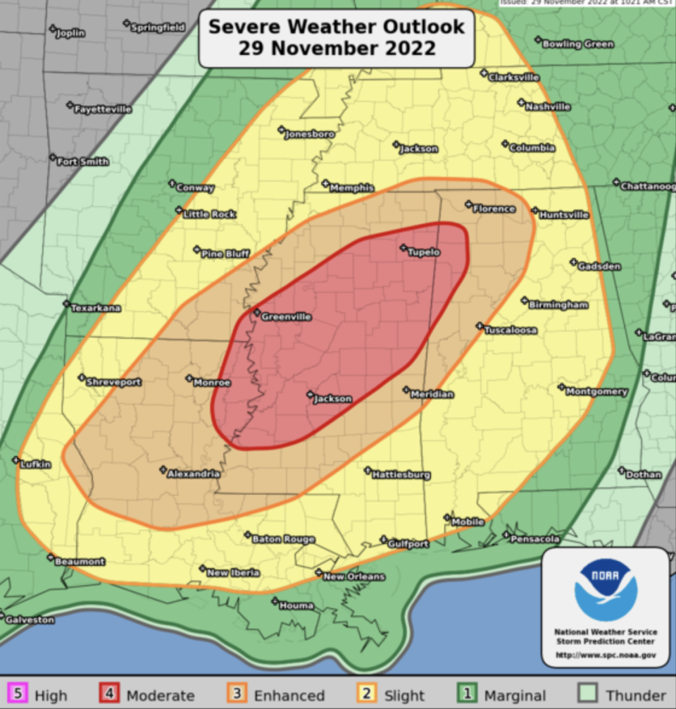
The national Storm Prediction Center said in its storm outlook that affected cities could include New Orleans; Memphis and Nashville in Tennessee; and Birmingham, Alabama. More than 25 million people were at risk as the vast storm system.
What is a derecho?
01:00 , Louise Boyle
A derecho is a wind storm that is long-lived, severe and takes place across a wide area.
Derecho-producing storm systems can also contain tornadoes, but they consist mostly of (and are defined by) damaging non-tornadic wind, according to the National Weather Service.
“Sometimes, an intense derecho can result in hundreds of severe wind and damage reports spread along a swath covering multiple states, with deaths, injuries, and many millions of dollars in losses,” the federal agency says.
It's hard to believe 6 months have passed since a historic derecho tore across Iowa- August 10, 2020. I've been working full time in TV weather for a little less than six years, and this will be the day I remember more vividly than any other. pic.twitter.com/a3g7Z5Fwxd
— Brandon Lawrence (@brandonlaw_wx) February 10, 2021
In August 2020, a powerful derecho struck the Midwest and caused more than $11billion in damages across eastern Nebraska, Iowa, Illinois, Wisconsin, and Indiana.
Winds reached 126mph (203 km/h) in Iowa and sustained winds held at around 70mph through the affected area.
There were blackouts across the region including in Cedar Rapids, Iowa which was left without power for weeks in some parts. There was also severe damage to crop staples like corn and soybeans in the agricultural stronghold.
What is a ‘particularly dangerous situation’ in relation to a tornado watch?
00:14 , Louise Boyle
According to the National Weather Service’s Storm Prediction Center, the “Particularly Dangerous Situation” wording is used in Tornado Watches for rare situations when long-lived intense tornadoes are likely.
The wording may also accompany Severe Thunderstorm Watches for widespread significant severe events, usually produced by exceptionally intense derechos.
PDS watches are issued, when in the opinion of the forecaster, the likelihood of significant events is boosted by very volatile atmospheric conditions.
What is the difference between a tornado watch and a tornado warning?
Tuesday 29 November 2022 23:30 , Louise Boyle
The National Weather Service differentiates between a tornado watch and tornado warning.
A Tornado Watch tells residents to be prepared that tornadoes are possible, in and near the watch area. People should go over their emergency plans, check supplies and safe rooms. The aim is to be ready to act quickly. Watches are issued by the Storm Prediction Center for counties where tornadoes may occur. The watch area is typically large, covering numerous counties or even states.
A Tornado Warning means take action because a twister has been sighted or indicated by weather radar. There is imminent danger to life and property. People should move to an interior room on the lowest floor of a well-constructed house or building, avoiding windows. If in a mobile home, a vehicle, or outdoors, move to the closest substantial shelter and protect yourself from flying debris. Warnings typically encompass a much smaller area (around the size of a city or small county) that may be impacted by a tornado.
Tuesday 29 November 2022 22:45 , Louise Boyle
What role the climate crisis is playing in the severity and frequency of tornadoes is still being heavily debated in the scientific community.
However recent research has suggested that the rising global temperature may be shifting the paths of tornadoes in the United States.
You can read more at the link below.
The climate crisis is widening ‘tornado alley’
Texas towns under tornado warning
Tuesday 29 November 2022 22:00 , Louise Boyle
A tornado warning remains in place for the Texas towns of Milam and Bronson until 3.45pm (central time) on Tuesday.
Around 1,500 people live in the towns close to the border with Louisiana.
Tornado Warning continues for Milam TX and Bronson TX until 3:45 PM CST pic.twitter.com/L9yyRqPIdB
— NWS Tornado (@NWStornado) November 29, 2022
More towns in Mississippi fall under tornado warnings
Tuesday 29 November 2022 21:37 , Louise Boyle
Tornado warnings continue for the towns of Winona, Vaiden, Kilmichael, McComb, Summit and Thompson in Mississippi until 3.45pm (central time).
In the area of Winona, Vaiden and Kilmichael, a tornado has been observed and hail was the size of tennis balls. More than 10,000 people live in the area where two hospitals and six schools are located.
McComb, Summit and Thompson have more than 24,000 residents, seven schools and one hospital. Radar was showing a tornado at this time and hailstones the size of quarters expected.
Video shows scale of dangerous storm from above
Tuesday 29 November 2022 21:15 , Louise Boyle
Weather Channel meteorologist Stu Ostro shared a clip of the storm from above which showed the size of the cells.
That shear already evident with the initial cells... dangerous afternoon/night ahead ⛈️🌪️ pic.twitter.com/3EDEOHZdO7
— Stu Ostro (@StuOstro) November 29, 2022
What do you do if caught in your vehicle during a tornado?
Tuesday 29 November 2022 20:59 , Louise Boyle
Being in a vehicle during a tornado is not safe, the National Weather Service warns.
The best move is to drive to the closest, well-constructed shelter. If this isn’t possible, then either get down in your car and cover your head, or abandon your car and seek shelter in a low lying area such as a ditch or ravine, the NWS advises.
The Weather Channel also has this helpful video.
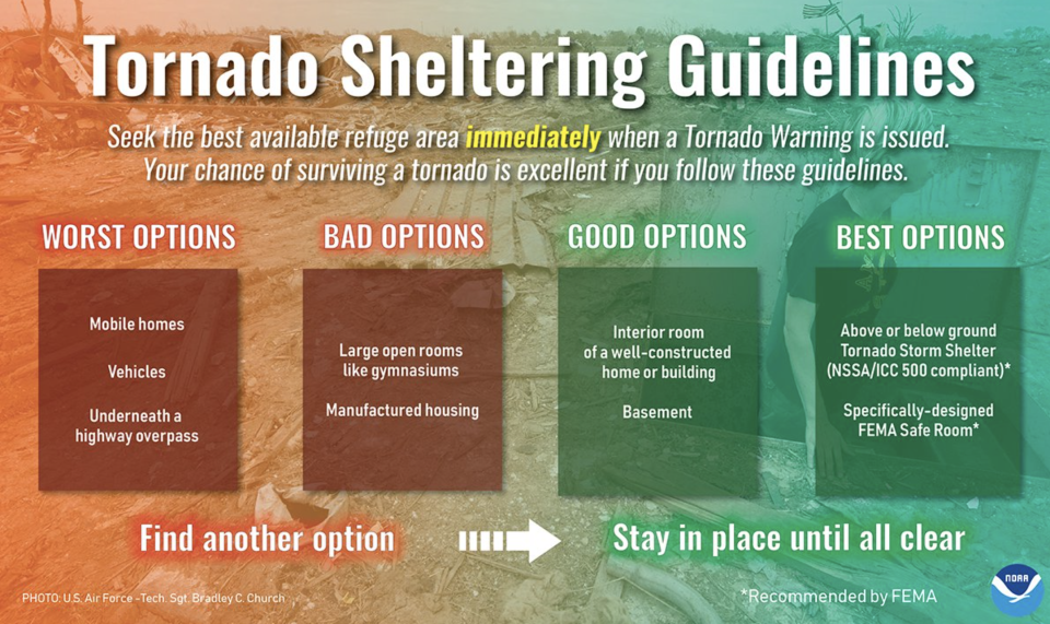
What makes a good tornado shelter?
Tuesday 29 November 2022 20:46 , Louise Boyle
The National Weather Service shared tips on Tuesday of how to take cover during tornadoes.
The best options are an above or below-ground tornado storm shelter that is compliant with the standards of the Federal Emergency Management Agency (FEMA). A specifically-designed FEMA safe room is also among the best options.
Good options are an interior room of a well-constructed house or building, or a basement.
Bad options are large, open rooms like gymansiums or manufactured housing.
The worst options are mobile homes, vehicles or underneath a highway overpass.
‘Pea-sized’ hail and tornado warning in Alabama
Tuesday 29 November 2022 20:09 , Louise Boyle
A tornado warning was put in place until 2.30pm (central time) in the small towns of Fruitdale and Yellow Pine, Alabama.
More than 1,350 people live in the area and two schools are located there, the National Weather Service reported.
Tornado Warning including Fruitdale AL and Yellow Pine AL until 2:30 PM CST pic.twitter.com/0YlWn8vKa9
— NWS Tornado (@NWStornado) November 29, 2022
Tornado watch stretches across the South
Tuesday 29 November 2022 19:41 , Louise Boyle
A tornado watch has been issued for parts of Arkansas, Louisiana and Mississippi until 7pm (central time) on Tuesday.
A tornado watch has been issued for parts of Arkansas, Louisiana and Mississippi until 7 PM CST pic.twitter.com/xkEHj0lsrl
— NWS Tornado (@NWStornado) November 29, 2022
Rare warnings
Tuesday 29 November 2022 19:12 , Louise Boyle
It’s rare that federal forecasters warn of major tornadoes with the potential for carving damages across long distances, but they are doing so in Tuesday’s forecasts, the Associated Press reported on Tuesday.
“Multiple rounds of severe thunderstorms -- some capable of long-tracked tornadoes with EF3+ damage potential -- will be possible this afternoon into tonight over parts of the lower Mississippi Valley region and Mid-South,” the Norman, Oklahoma-based Storm Prediction Center said.
Tornadoes with an EF3 rating on the Enhanced Fujita tornado scale can produce wind gusts of up to 165 mph (266 kph).
Forecasters warned of the potential for strong tornadoes that could stay on the ground for long distances in parts of the South, as well as flooding rains and hail the size of tennis balls.
More than 25 million people will be at risk as Tuesday’s potent storm system moves across a region stretching from east Texas to Indiana and Georgia. The national Storm Prediction Center said in its latest storm outlook that affected cities could include New Orleans; Memphis and Nashville in Tennessee; and Birmingham, Alabama.
Parts of Louisiana and Mississippi will be at the highest risk for strong storms Tuesday afternoon and evening, with the possibility of severe weather continuing into Wednesday and moving into Alabama.
AP
How to prepare
Tuesday 29 November 2022 19:00 , Louise Boyle
Dr Rick Knabb, a hurricane expert at The Weather Channel, shared tips on how to stay safe during the severe weather.
“Tornado watch doesn’t mean wait until a warning to take any action,” he tweeted “There are things to do right now so you’re ready to quickly take cover in safest room when warning issued. First and foremost get out of mobile homes, off roads, into sturdy building now.
Tornado watch doesn’t mean wait until a warning to take any action. There are things to do right now so you’re ready to quickly take cover in safest room when warning issued. First and foremost get out of mobile homes, off roads, into sturdy building now. https://t.co/EkiqXRxwf7 pic.twitter.com/pwkaozSr8W
— Dr. Rick Knabb (@DrRickKnabb) November 29, 2022
The regions at risk
Tuesday 29 November 2022 18:50 , Louise Boyle
The most recent update from the National Weather Service Storm Center in Norman, Oklahoma, in the heart of Tornado Alley, provided the list of the areas to be prepared for severe weather.
Strong tornadoes, very large, “baseball-sized” hail, and severe wind gusts are forecast from Tuesday afternoon into tonight in Northern Alabama, Northeast Louisiana, Southeast Arkansas, Southern Tennessee.
Watch: Forecasters warn of extreme weather on the way
Tuesday 29 November 2022 18:39 , Louise Boyle
Tornado warnings begin in Louisiana
Tuesday 29 November 2022 18:03 , Louise Boyle
Tornado warnings started to pop up early on Tuesday afternoon from the National Weather Service’s official Twitter account
Among the first were for the tiny towns of Mamou, Pine Prairie and Reddell in Evangeline Parish, Louisiana until 12.15pm (Central Time).
Tornado Warning continues for Mamou LA, Pine Prairie LA and Reddell LA until 12:15 PM CST pic.twitter.com/X34FTfe4AE
— NWS Tornado (@NWStornado) November 29, 2022
Why it’s so hard to know if tornadoes are caused by climate change
Tuesday 29 November 2022 17:40 , Louise Boyle
In December 2021, a powerful tornado outbreak across six US states left dozens of people dead.
At the time, I wrote about the difficulty of linking these events to the climate crisis.

Why it’s so hard to know if the Kentucky tornado was caused by climate change
Meteorologist posts shelter locations
Tuesday 29 November 2022 16:48 , Sam Webb
Thank you as well to the meteorologists who have helped share the information I have developed on #tornado shelters. There are hundreds of them in the region that counties will likely open once the threat begins.
The map link is pinned to my profile. #MSwx #ALwx #TNwx pic.twitter.com/hY2fA7F9Cu— Craig Ceecee (@CC_StormWatch) November 28, 2022
What is a tornado?
Tuesday 29 November 2022 16:39 , Sam Webb
Tornadoes are whirling, vertical air columns that form from thunderstorms and stretch to the ground. They travel with ferocious speed and lay waste to everything in their path.
Thunderstorms occur when denser, drier cold air is pushed over warmer, humid air, conditions scientists call atmospheric instability. As that happens, an updraft is created when the warm air rises. When winds vary in speed or direction at different altitudes — a condition known as wind shear — the updraft will start to spin.
These changes in winds produce the spin necessary for a tornado. For especially strong tornadoes, changes are needed in both the wind’s speed and direction.
More from the Independent on tornadoes and how the climate crisis makes them worse here.
Still some risk tomorrow
Tuesday 29 November 2022 16:24 , Sam Webb
According to weather.com, the potential for severe weather will decrease on Wednesday. However, some parts of the Southeast could see one to two inches of rain and flash flooding is possible in areas where too much rain falls too quickly.
Meteorologist explains threat levels
Tuesday 29 November 2022 16:00 , Sam Webb
Meteorologist Craig Ceecee has outlined what the storm categories mean:
What do the storm categories mean? They mean the confidence level, as well as the expected amount of reports, of severe storms.
Don't assume you're not at risk - or let the guard down - if you're outside the maximum threat. The #tornado threat expands well outside the peak area. pic.twitter.com/XnLSW18SWJ— Craig Ceecee (@CC_StormWatch) November 29, 2022
He added: “If you can’t get to your safe place from home, or up and out, in 5 minutes - especially if in a mobile home or weaker structure - you should spend the time under #tornado threat tomorrow somewhere else (with family/friends, at work or at a shelter).”
Safety plan is ‘imperative'
Tuesday 29 November 2022 15:47 , Sam Webb
Meteorologist for @WCBINEWS Jackson Chastain tweeted: “This is what we are up against. A Tornado Watch is likely by early this afternoon.
“The window is large, as is the potential for several long-track tornadoes. It is imperative that you have a safety plan going into this evening.”
This us what we are up against. A Tornado Watch is likely by early this afternoon. The window is large, as is the potential for several long-track tornadoes. It is imperative that you have a safety plan going into this evening. #mswx #alwx pic.twitter.com/ZplIqr1LLm
— Jackson Chastain (@jchastainwx) November 29, 2022
Take picture for insurance. residents urged
Tuesday 29 November 2022 15:43 , Sam Webb
The Mississippi Emergency Management Agency is urging homeowners to photograph their property before the storm hits for insurance purposes. It tweeted: “We encourage Mississippians to take photos of their home BEFORE the storms. These photos can be used for insurance purposes and/or possible assistance if your home is damaged in the storm.”
⚠️SEVERE WX FOR TODAY (11/29)⚠️
The NWS updated the risk map for today's wx. Storms, hail, damaging winds, and tornadoes are all possible. STAY INFORMED!
📲Set alerts to LOUD to wake you
🏡 Know your safe place
💡Prepare for power outages
🚗Stay off the roads if possible pic.twitter.com/aVHbnuOgF6— msema (@MSEMA) November 29, 2022
‘Make decisions quickly'
Tuesday 29 November 2022 15:40 , Sam Webb
Bill Bunting, chief of forecast operations at the Storm Prediction Center, told CNN Weather, said: “Another challenge with nighttime tornadoes, especially in the fall and winter, is that storms typically move very quickly, at times 50 or 60 mph.
“This means that you must make decisions quickly and take shelter based on information contained in the severe thunderstorm or tornado warning, and not wait until the storm arrives,” he added.
Hail and strong wind also a threat
Tuesday 29 November 2022 15:39 , Sam Webb
A total of three million people across much of Mississippi and parts of western Alabama, southwestern Tennessee, eastern Arkansas, northern Louisiana, and a small part of eastern Texas are at risk of hail, strong wind, and tornadoes.

