
Beryl forms; expected to become 1st major hurricane of 2024 season


Tropical Storm Beryl has developed over the Atlantic Ocean and is forecast to track into the Caribbean Sea and become the first hurricane of the 2024 season.
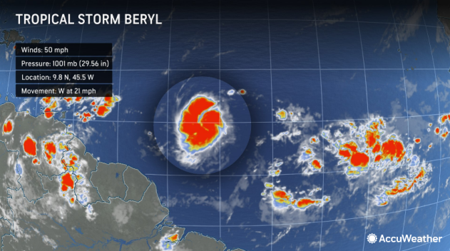
The fledgling tropical storm, packing sustained winds of 60 mph, is just one of several disturbances that AccuWeather meteorologists are tracking across the Atlantic hurricane basin.
Over the past couple of days, one particular batch of showers and thunderstorms over the south-central Atlantic emerged in center stage, first organizing to become a tropical depression on Friday afternoon then strengthening to a tropical storm Friday evening. Satellite images on Friday morning indicated wispy high-level clouds fanning out over the system's top, a telltale sign that it was strengthening.
 |
AccuWeather began referring to the system as a tropical rainstorm on Thursday to help raise public awareness of the risk to lives and property along the storm's path.
A hurricane watch has been issued for Barbados, with more watches likely to follow as Baryl approaches the Caribbean.
 |
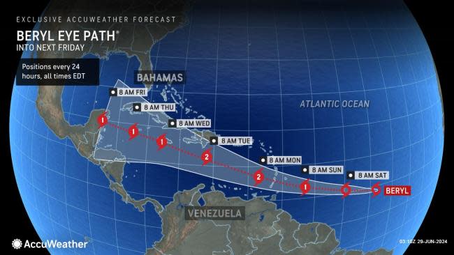
"Steering breezes will guide the system to cross the Windward Islands of the eastern Caribbean from Sunday night to Monday, then waters near Jamaica during the middle of next week and perhaps to the shores of Central America or southeastern Mexico at the end of next week," AccuWeather Senior Storm Warning Meteorologist Eddie Walker said.
With Beryl now at tropical storm intensity well to the east of the Windward Islands, some of these islands will experience tropical storm conditions with squally rains, gusty thunderstorms and rough seas as early as Sunday before the center's arrival. However, the storm is expected to reach Category 2 hurricane strength (sustained winds of 96-110 mph) before it reaches the Windwards.
"Tropical storm formation south of 20 degrees north latitude and east of 60 degrees west longitude is rare this time of the year," AccuWeather Chief On-Air Meteorologist Bernie Rayno said, "Only seven named storms have formed over the last 173 years in this sector of the Atlantic before July 4."
Interaction with South America and the larger islands of the Caribbean, as well as bouts of wind shear and dry air, may inhibit intensification as the depression moves along. However, should Beryl stay in the moist zone and away from large land areas, it has the potential to ramp up quickly, with strengthening to a major hurricane (sustained winds of 111-129 mph) expected during the day on Monday.
 |
The AccuWeather RealImpact™ Scale for Hurricanes is a 2 for the Lesser Antilles in the eastern Caribbean because of the expectation that the storm reaches hurricane intensity before moving through the islands. Higher levels of the AccuWeather RealImpact™ Scale for Hurricanes may be warranted farther to the west over the Caribbean, depending on the system's intensity and track.
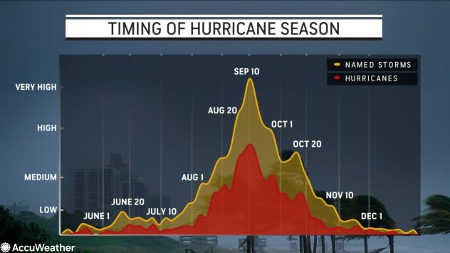
Seeing such vigorous tropical activity from the wave train is unusually early for this point of the season. Storms typically do not strengthen regularly over the main hurricane development zone until mid-August or later. The period from late June through much of July is typically quiet, with only one or two named systems by mid- to late July.
 |
Peak Timing / Frequency of Hurricane Season |
"We continue to observe much higher-than-historical-average water temperatures over most of the Atlantic, and this is the premise for the robust activity now and that AccuWeather has been anticipating a super-charged hurricane season for 2024 since this past winter," Walker said.
This exceptional warmth may also trigger the rapid strengthening of tropical systems as the season progresses. When rapid strengthening occurs near land, it may cause an exponential increase in the danger to lives and property with little notice.
 |
Depending on steering breezes, Tropical Storm Beryl may push westward across Central America later next week or turn northwestward and reach the western Gulf of Mexico next weekend, where it would become a concern for the United States. For this reason, all interests in the Caribbean, Central America and the Gulf Coast of the U.S. are urged to monitor the system's progress.
Elsewhere over the Atlantic basin, another tropical wave is approaching Central America. As it moves northwestward, this system has a medium chance of becoming a tropical depression before tracking into east-central Mexico on Sunday. However, it will interact significantly with land, which may prevent development.
 |
Regardless, this feature will bring torrential downpours and locally gusty thunderstorms from the northwestern Caribbean to the shores of Mexico in the southwestern Gulf of Mexico this weekend. There will be the risk of flash flooding and mudslides in hilly terrain. Areas needing rain along its path will receive some drought and wildfire relief.
Thousands of miles to the east, additional tropical waves will be watched closely for possible tropical development as they drift westward over the next couple of weeks. There is a growing expectation that a storm immediately behind Beryl will evolve into an organized tropical entity.
 |
Should a second system develop in the coming days or weeks following the central Atlantic feature, the third name on the list of tropical storms for the 2024 season is Chris.
Tropical Storm Alberto formed in early June and tracked across the southwestern Gulf of Mexico before moving inland over northeastern Mexico.
 |
Want next-level safety, ad-free? Unlock advanced, hyperlocal severe weather alerts when you subscribe to Premium+ on the AccuWeather app. AccuWeather Alerts™ are prompted by our expert meteorologists who monitor and analyze dangerous weather risks 24/7 to keep you and your family safer.
