
Tammy eyes Bermuda after Hurricane Otis makes unprecedented landfall in Mexico as a Category 5 storm


Following the historic landfall of Otis, which slammed Mexico with a catastrophic blow as a Category 5 hurricane, AccuWeather hurricane experts are tracking another tropical feature churning in the Atlantic.
Hurricane Otis made landfall near Acapulco, Mexico, early Wednesday morning as a dangerous Category 5 storm on the Saffir-Simpson Hurricane Wind Scale, with life-threatening and destructive flash flooding and mudslides. It has since lost wind intensity while churning over land.
The landfall was historic in more than one way. The part of Mexico where Otis slammed ashore had never endured a landfall from a major hurricane - Category 3 or higher. There has also never been an Eastern Pacific Category 5 hurricane landfall before.
Otis will also go down in the history books for extremely rapid intensification over the East Pacific before it struck land.
Acapulco, Mexico, close to where Otis roared ashore, is home to about 1 million people. Not only was there catastrophic damage, but significant loss of life and injuries are still expected to result from this storm due to prior storm surge and powerful winds, as well as ongoing flooding and mudslides.
"There is no historical precedent for a landfalling major hurricane in this part of Mexico," AccuWeather Director of Forecasting Operations Dan DePodwin said, adding, "It has not happened in recorded history."
 |
AccuWeather alerted its followers that Otis could become a hurricane as early as Monday evening local time.
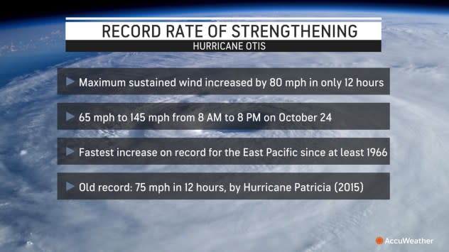
The tropical cyclone's wind intensity increased from a 50-mph tropical storm at 4 p.m. CDT on Monday to a 165-mph Category 5 hurricane at 1:00 a.m. CDT on Wednesday. Since making landfall, the storm has lost wind intensity. It was once again a tropical storm with 60-mph sustained winds as of 1 p.m. CDT Wednesday before dissipating over the mountainous terrain of Mexico Wednesday afternoon.
During the first part of this week, the storm rapidly strengthened, which occurs when winds increase by 35 mph or greater in 24 hours or less. In fact, the sustained winds in Hurricane Otis increased by 80 mph in 12 hours, the most rapid intensification on record for the East Pacific basin since at least 1966. AccuWeather placed an AccuWeather Local StormMax™ wind gust of 210 mph for Otis.
AccuWeather Chief Meteorologist Jonathan Porter stated Tuesday evening, "Otis will bring a wide variety of life-threatening impacts to parts of the Mexican coastline, including the major population center of Acapulco, home to almost one million people. A major hurricane has not made landfall in this area in modern times. Otis may result in catastrophic damage and will quickly become a humanitarian crisis in the wake of the storm, with many people needing medical care and supplies, food, shelter and safe drinking water."
Heavy rain, destructive winds and a life-threatening storm surge accompanied the storm as it moved inland Tuesday night and Wednesday. This brought significant flooding and mudslides, catastrophic damage to structures, and widespread downed trees and power lines. Due to impacts from heavy rain, wind, and storm surge, Otis was rated a 5 on the AccuWeather RealImpact™ Scale for Hurricanes in Mexico, a rare, highest-level designation on the exclusive AccuWeather RealImpact™ Scale for Hurricanes, showcasing the truly dire situation that evolved in the area where Otis made landfall.
A weather station located on a small island just south of Acapulco recorded impressive observations from Otis during the middle of Tuesday night. Sustained winds of 81.1 mph were observed with maximum wind gusts of 134.6 mph at an elevation of 351 feet above sea level.
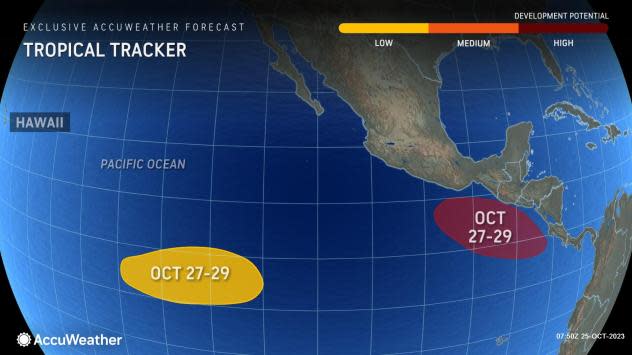
AccuWeather meteorologists continue to monitor the former tropical depression that formed in the western Caribbean early this week. That system pushed inland over Central America and has now emerged in the eastern Pacific.
 |
Satellite data suggest that this system is gaining organization over warm waters and could become the next tropical storm and hurricane.
"There is the potential for this system to impact areas later this week that were recently devastated by Hurricane Otis," Porter said.
Tammy gained some strength since Tuesday morning when it was a Category 1 hurricane with 75 mph sustained winds. However, the storm started to interact with a frontal system on Wednesday, and by early Thursday, Tammy transitioned to a tropical wind and rainstorm while still packing hurricane-force sustained winds of 85 mph, spinning to the east-southeast of Bermuda. A hurricane has sustained winds of at least 74 mph on the Saffir-Simpson Hurricane Wind Scale.
AccuWeather meteorologists say that it will track to the west-northwest into the start of the weekend before turning first to the north then to the east as it moves away from the Caribbean.
Since developing on Wednesday, Oct. 18, Tammy has traveled over 1,500 miles across the Atlantic Ocean, including a brush with the Leeward Islands.
 |
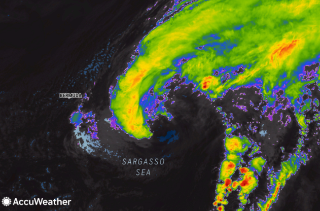
Tammy appears in the middle of this image on Thursday morning, Oct. 26, 2023. Bermuda is located to the left of the center. High-level clouds from Tammy extend for thousands of miles across the Atlantic and are reaching Spain and Portugal. (AccuWeather Enhanced RealVue™ Satellite) |
When Tammy, as a hurricane swirled over the eastern Caribbean islands, it brought rounds of drenching rain to locations of Barbados and St. Lucia and northward through the British and U.S. Virgin Islands from Friday through Monday. Tammy brought widespread rainfall amounts between 2 and 4 inches (50 and 100 mm) across the islands. Across Guadeloupe, Antigua and Barbuda, rainfall totals ranged from 4-8 inches (100-200 mm) with the AccuWeather Local StormMax™ of 10 inches (250 mm).
Residents of Le Raizet, Guadeloupe, where the main airport on the island presides, reported rainfall totals of 9.39 inches (238.60 mm) from Friday to early Monday as Tammy churned over the region.
Conditions in Guadeloupe deteriorated on Saturday as gusty winds, heavy rain and storm surge impacted the island. A gust of 90 mph (145 km/h) was reported in Barbuda as the center of the storm approached the northeastern corner of the Leeward Islands, approaching the AccuWeather Local StormMax™ of 100 mph (160 km/h) set for the Caribbean islands from Hurricane Tammy.
"More than a dozen island nations there were impacted by pounding surf, dangerous rip currents, heavy rain and strong winds as Tammy moved through," stated AccuWeather Senior Meteorologist Bill Deger.
AccuWeather meteorologists continue closely monitoring the latest trends and analyzing the path that Tammy could take over the next several days. However, they say that the answer of which direction the storm may travel is not exactly clear at the moment.
"Once you get to Thursday, there is a wide range of possibilities of where Tammy could go," AccuWeather Senior Meteorologist and Lead Hurricane Forecaster Dan Kottlowski said.
 |
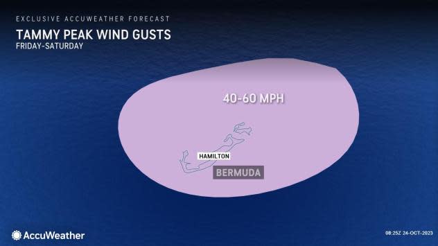
Tammy may lose some wind intensity through the day on Thursday as it encounters strong wind shear, or disruptive winds in the atmosphere that can affect tropical cyclone organization. Into early next week, forecasters say that impacts from Tammy may be felt across the islands of Bermuda.
Hurricane experts note that the main impacts from Tammy across Bermuda will be flooding downpours, gusty winds and rough surf. From Friday through Monday, general rainfall amounts of 1-2 inches (25-50 mm) can expand across Bermuda as Tammy passes nearby. Peak wind gusts can reach speeds of 40-60 mph across the islands during the same timeframe.
 |
Forecasters say that direct impacts from Tammy to the United States are not likely at this time.
However, a plume of moisture, known as an atmospheric river, will extend all the way from Tammy near Bermuda to parts of Europe through the end of this week and into the weekend. There is the potential for flooding rainfall in parts of Spain, Portugal and France, where the band of rain persists.
Want next-level safety, ad-free? Unlock advanced, hyperlocal severe weather alerts when you subscribe to Premium+ on the AccuWeather app. AccuWeather Alerts™ are prompted by our expert meteorologists who monitor and analyze dangerous weather risks 24/7 to keep you and your family safer.
