
Typhoon Bolaven explodes into violent typhoon, could affect US weather down the road

Typhoon Bolaven, a violent typhoon in the West Pacific basin, walloped the island territory of Guam and the Northern Mariana Islands early this week, engulfing the islands in heavy rain and gusty winds.
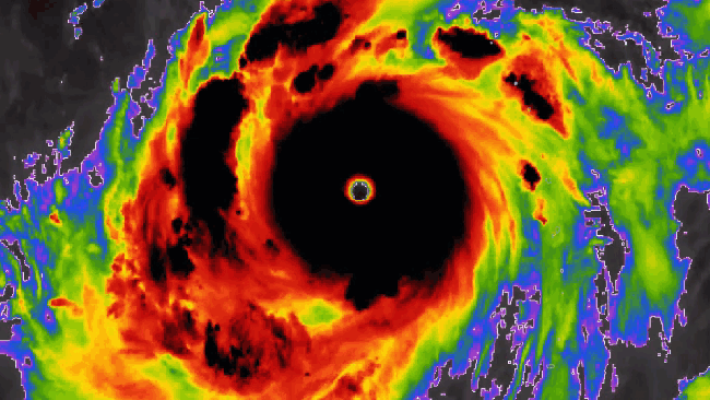
Bolaven became a tropical storm Saturday about several hundred miles to the southeast of Guam. On Wednesday night, Bolaven rapidly intensified into a violent typhoon packing maximum sustained winds of over 130 mph (about 210 km/h).
A peak wind gust of 68 mph (109 km/h) was recorded on Saipan Island, part of the Northern Mariana Islands, as Bolaven passed over the region Tuesday and Tuesday night. Wind gusts of 46 mph (74 km/h) were observed at Guam International Airport Tuesday as the center of Typhoon Bolaven passed roughly 50 miles (80 km) northeast of the island.
 |
Typhoon Bolaven spins on AccuWeather RealVue™ Satellite late Wednesday evening local time. |
From Monday evening to Tuesday evening, rainfall reports from Agana, Guam, reached nearly 4 inches (101 mm). Nearby locations, such as Guam International Airport, observed upwards of 2.13 inches (54 mm) on Tuesday alone.
Bolaven underwent a period of rapid intensification from Tuesday night to Wednesday morning, local time, in which winds increased by 70 mph (110 km/h) in a 12-hour period. Rapid intensification of a tropical cyclone is defined as an increase in maximum sustained winds of 35 mph or more in a period of 24 hours or less.
Typhoon Bolaven's lowest pressure and highest wind readings are similar to the last notable West Pacific typhoon to impact Guam and the Northern Mariana Islands -- Typhoon Mawar. That storm occurred in May, and was the equivalent of a Category 4 hurricane (maximum sustained winds of 130-156 mph, or 209-251 km/h).
Typhoon Mawar brought peak winds of 149 mph (240 km/h) across the islands during the last week of May, and the center of the storm tracked directly between Guam and Rota Island, part of the Marianas. Nearly the entire island territory of Guam was without power after Mawar impacted the region. At one point, less than 2% of customers across Guam had access to electricity, according to the Guam Power Authority.
Looking at the long-term track of Bolaven, AccuWeather meteorologists are concerned that the storm may eventually stir up trouble across the Gulf of Alaska late next week.
"[Bolaven] in the western Pacific can recurve, weaken, then intensify rapidly heading toward the Gulf of Alaska early to middle of next week," said AccuWeather Lead Long-Range Forecaster Paul Pastelok.
The storm's impact on Alaska can eventually trickle down to influence the weather pattern along the West Coast of the United States.
"This could be a massive storm with high winds and heavy rain along the southern coast of Alaska. Seas will build across this region and can impact the U.S. West Coast. Snowfall in the southeastern mountains of Alaska and western Canada will be measured in feet," stated Pastelok.
Want next-level safety, ad-free? Unlock advanced, hyperlocal severe weather alerts when you subscribe to Premium+ on the AccuWeather app. AccuWeather Alerts™ are prompted by our expert meteorologists who monitor and analyze dangerous weather risks 24/7 to keep you and your family safer.
