
More snow, rain eye Northeast to end the week


Temperatures will be on an upward trend this week across the center and eastern half of the nation, AccuWeather forecasters say. However, the next storm is already on the horizon.
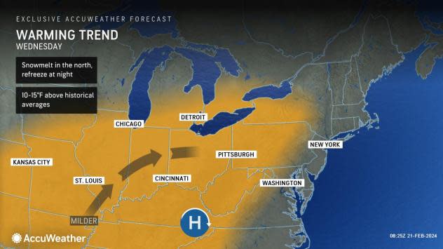
Daytime highs are projected to transition from the 20s and 30s over the past weekend to the 40s and 50s by midweek. Partly to mostly sunny skies will accompany the rising temperatures, making for a rather mild stretch by mid-February standards.
Any leftover snow cover from the start of the weekend will melt quickly over the coming days. Overnight lows dipped below freezing across portions of the Great Lakes, Ohio Valley, mid-Atlantic and New England regions during the first half of this week, meaning any puddles or wet patches from the snow melting were able to refreeze in the evening, creating slippery conditions at night and at the start of the day.
 |
The mild weather across the Ohio Valley and mid-Atlantic states on Wednesday may be considered nice enough to allow people to begin some springtime yard work preparations or even enjoy outdoor recreation. For most, the increasing temperatures will be welcomed following the brisk weekend conditions.
By later Wednesday into Thursday, it can become breezy from the Mississippi Valley through the interior Northeast as the next storm approaches the region.
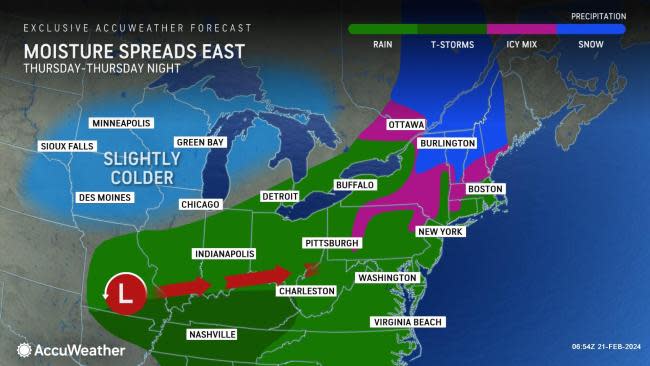
By late in the week, a storm system will become more organized across the Plains and gradually spread rain into the Ohio Valley and interior Northeast. As a branch from the northern storm swings southeastward through Canada, the system will meet up with a low-pressure system that brought heavy rainfall to California at the beginning of the week.
 |
The southern flank of the storm, originating along the West Coast, will spark thunderstorms farther south from northeastern Oklahoma to western Kentucky Wednesday night into Thursday, potentially bringing hail and locally damaging wind gusts. As the storm shifts eastward to the mid-Atlantic coast Thursday night, rain and showers will spread into the Delmarva Peninsula.
"Rain could be locally heavy with a rumble of thunder even possible in the Ohio Valley. In tandem with melting snow, some areas will experience issues with ponding water, especially in low-lying and prone areas," explained AccuWeather Meteorologist Joseph Bauer.
Between Thursday and Friday, rainfall totals can range from 1-1.5 inches across portions of the Ohio Valley and mid-Atlantic as this storm advances eastward.
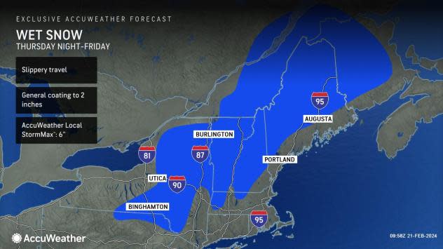
Portions of New York, Vermont, New Hampshire and Maine will have the best chance of getting snow later this week, especially across higher terrain. Cold air pressing southward out of Canada will linger across areas of the Catskills, Adirondacks, Green and White Mountain ranges. A general coating to two inches of snow can accumulate across this region, with higher totals possible in the higher elevations.
 |
"Into the Northeast, the storm will quickly track by on Friday. Snow is possible, mainly in the terrain areas of the Northeast, with rain likely across the southern New England," explained Bauer.
As overnight lows fall near or below freezing Friday night, some snow or a mix of rain and snow can occur farther south into southern New York, northern Pennsylvania and lower New England.
 |
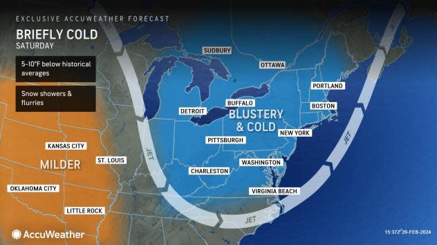
Following the warmup into midweek across the East, forecasters say brisk air can filter southward from Canada behind the storm and bring temperatures down to 5-10 degrees below historical averages.
"There could be issues with groundwater freezing and creating slick spots over the weekend," added Bauer.
Conditions can become quite breezy from the Great Lakes to the mid-Atlantic by Friday and Saturday, highlighting the risk of snow showers off the lakes. AccuWeather RealFeel® Temperatures Friday evening can range several degrees lower than actual values due to the blustery conditions.
 |
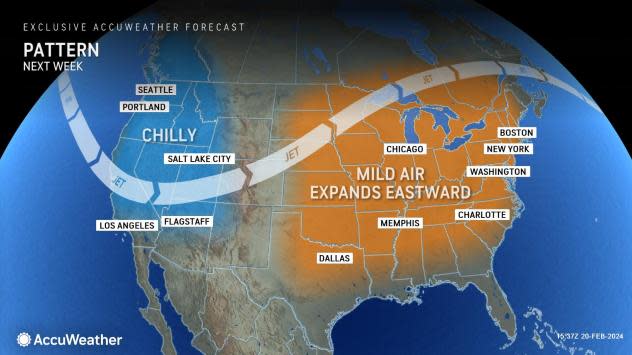
The cold burst may be brief; by early next week, the mild air is set to return to the eastern United States as the jet stream surges northward once again. Daytime highs in places like Pittsburgh and Philadelphia are expected to climb into the upper 50s and lower 60s by the middle of next week.
Want next-level safety, ad-free? Unlock advanced, hyperlocal severe weather alerts when you subscribe to Premium+ on the AccuWeather app. AccuWeather Alerts™are prompted by our expert meteorologists who monitor and analyze dangerous weather risks 24/7 to keep you and your family safer.
