
Multiple tropical threats possible, including in Gulf of Mexico, after Florida tropical rainstorm


As a tropical rainstorm continues to unload torrential downpours that will trigger dangerous flash flooding in parts of Florida into the end of the week, additional areas are under the close eye of AccuWeather meteorologists through much of June. The potential tropical storm breeding grounds include areas from off the southern Atlantic coast, through the Gulf of Mexico and into the eastern Pacific.
While there are currently no systems on the verge of developing, conditions can change significantly over the course of the next week in the Atlantic and eastern Pacific basins.
 |
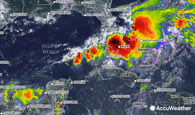
The tropical rainstorm, as seen on AccuWeather RealVue™ Enhanced Satellite on Wed. afternoon, June 12, 2024. |
Florida had been sweltering in excessive heat and struggling with abnormally dry to drought conditions prior to the arrival of the tropical rainstorm early Tuesday. Radar estimates indicate that up to 11 inches of rain has already fallen in parts of southwestern Florida from the rainstorm, as of Wednesday afternoon, including in Fort Myers, where over 5 inches was reported.
"This will be like a wall of water coming at southern and central Florida into Thursday," AccuWeather Chief On-Air Meteorologist Bernie Rayno said.
 |
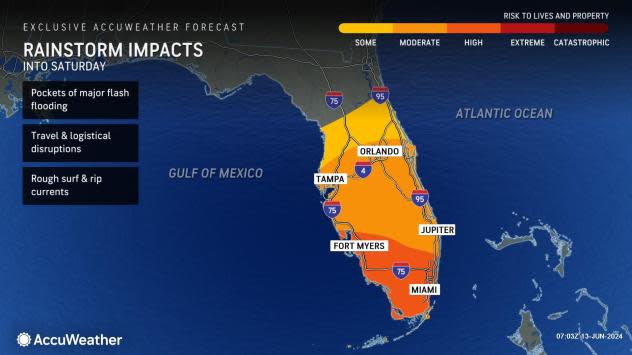
Motorists should expect to encounter flooded roads, and pedestrians may have their paths blocked by high water. Major delays and flight cancellations are likely at the airport hubs in central and South Florida until at least Thursday.
"The steadiest and heaviest rain will fall on South and central Florida through Thursday, but more spotty downpours and thunderstorms will continue to pester the region into Saturday," AccuWeather Senior Meteorologist Reneé Duff said.
 |
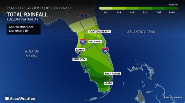
Total rainfall in parts of South Florida will range between 18 and 24 inches with an AccuWeather Local StormMax™ of 30 inches, which is on par with a major slow-moving tropical storm or hurricane. Rainfall of 4-8 inches with locally higher amounts will be common in southeastern and central Florida. This heavy rainfall can lead to flooding on the streets, highways and low-lying areas. Some of the rivers in the region will rise above flood stage.
For many areas in central and South Florida, the rainfall over the next few days may approach or exceed the total amount of rain that fell through the first five months of 2024.
 |
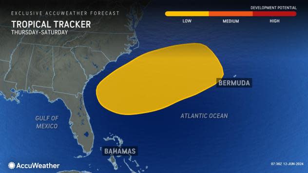
As this system moves northeastward and off the southern Atlantic coast late this week to this weekend, it may enter a favorable environment for development from west of Bermuda to east of Georgia and the Carolinas.
"This feature will move parallel to wind shear and over warm waters, which could foster tropical or subtropical development," AccuWeather Lead Tropical Meteorologist Alex DaSilva said. Wind shear, which is strong or shifting breezes through the atmosphere, can deter development but, in rare cases, can help encourage development.
 |
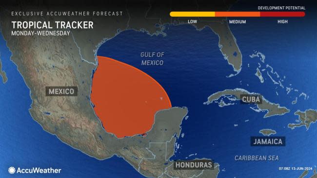
AccuWeather forecasters warn that this feature is not the only system that may develop into a named tropical system in the coming days.
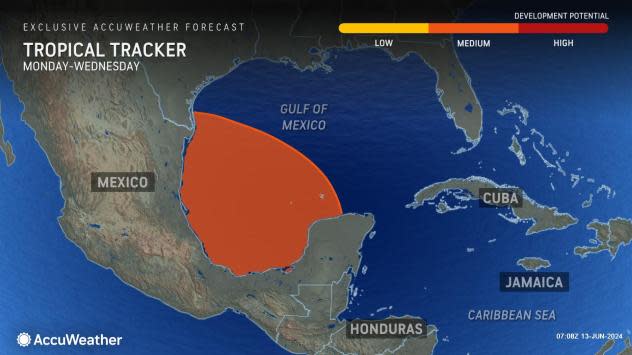
The next potential system will behave similarly to a tropical rainstorm as a broad southeasterly breeze develops over the Gulf of Mexico beginning Sunday which may last well into next week. At roughly the same time, another disturbance may emerge from the northwestern Caribbean and could slowly brew over the central or western Gulf of Mexico.
 |
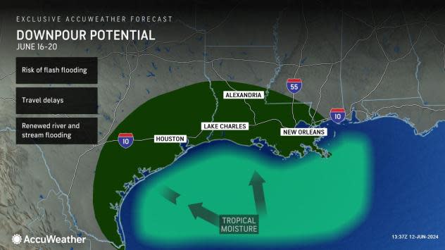
The area from near Pensacola, Florida, to near Port Lavaca, Texas, which includes the major metro areas of New Orleans and Houston, is forecast by AccuWeather meteorologists to be affected by torrential downpours and the risk of flash flooding.
The risk will begin from the western tip of the Florida Panhandle to southeastern Louisiana Sunday and expand inland and westward into next week.
 |
"Regardless of any organization into a tropical depression, this feature will pump a significant amount of moisture onshore over the central Gulf Coast region in the form of heavy rain from Sunday to Tuesday, which may expand westward to much of South Texas later next week," AccuWeather Meteorologist Joseph Bauer said.
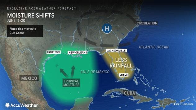
The extent and magnitude of rain for Texas will depend on the strength of a heat dome predicted over the Eastern states next week.
"A strong high pressure area in the East could pump excessive tropical moisture into Texas later next week," AccuWeather Lead Long-Range Meteorologist Paul Pastelok said.
 |
Regardless, there is the potential for enough rain to fall on rivers in northeastern Texas that have already experienced multiple rounds of major flooding this spring.
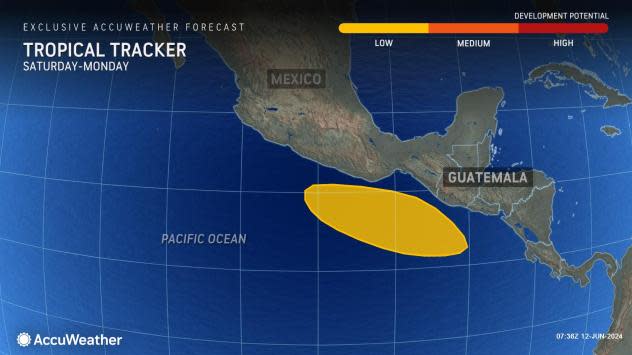
A developing large, slowly spinning area of low pressure called a gyre will promote tropical downpours in the Gulf of Mexico, the northwest Caribbean and the nearby coastal areas of the eastern Pacific along the coast of southern Mexico and Central America, DaSilva explained.
 |
As disturbances roll into this zone, there is the potential for one or more to develop into a tropical system.
"For this reason, we are watching the eastern Pacific and the Gulf closely for tropical development on one or more instances from this weekend through the end of June," DaSilva said.
 |
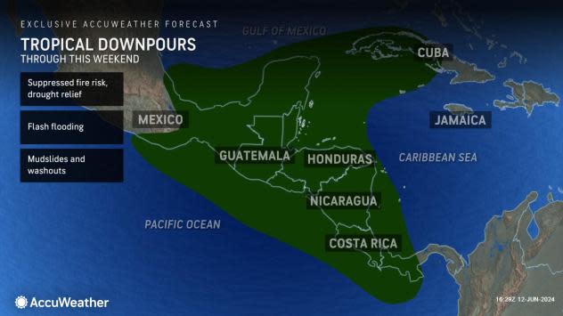
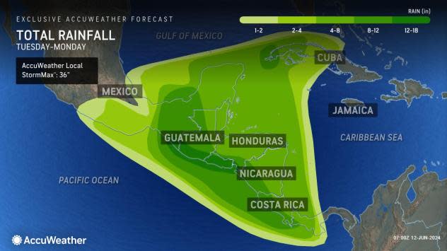
The nearly stationary gyre and its embedded disturbances, spinning around like a slow-motion, multivortex tornado, will grab and unload moisture by way of heavy rain on portions of Central America and southern Mexico this week and into next week.
The AccuWeather Local StormMax™ rainfall for this zone through Monday is a staggering 36 inches. In hilly and mountainous areas, life-threatening mudslides could occur where rain falls over several days. At the very least, enough rain will fall to lead to dangerous flash flooding.
 |
However, just as in parts of Florida, the frequent downpours will help to alleviate drought and wildfire risk.
Despite the latest start to the tropical Atlantic season since 2014, when the first storm did not form until July 1, AccuWeather meteorologists anticipate a super-charged year for tropical systems, including multiple threats to the U.S., the Caribbean, and Central America.
 |
Water temperatures over much of the Atlantic hurricane basin continue to run well above historical averages, so there is great potential for energy to fuel tropical activity.
The first few names on the list of 2024 Atlantic tropical storms are Alberto, Beryl and Chris. Meanwhile, on the eastern Pacific side, the first few names for 2024 are Aletta, Bud and Carlotta.
Want next-level safety, ad-free? Unlock advanced, hyperlocal severe weather alerts when you subscribe to Premium+ on the AccuWeather app. AccuWeather Alerts™ are prompted by our expert meteorologists who monitor and analyze dangerous weather risks 24/7 to keep you and your family safer.
