
North Korea building border ‘wall’, satellite images reveal
North Korea is building sections of what appears to be a wall in several places near its border with South Korea, new satellite images reveal.
Images analysed by BBC Verify also show that land inside the Demilitarised Zone (DMZ) has been cleared, which experts say could be a violation of the long-standing truce with South Korea.
The DMZ is a 4km (2.5 miles) wide buffer zone between North and South Korea, who are still technically at war having never signed a peace treaty. The DMZ is split in two, with each side controlled by the respective nations.
This recent activity is “unusual”, according to experts, and comes at a time of rising tensions between the two countries.
“At this point we can only speculate that North Korea is looking to strengthen its military presence and fortifications along the border,” says Shreyas Reddy, a correspondent at the specialist site NK News, based in Seoul.
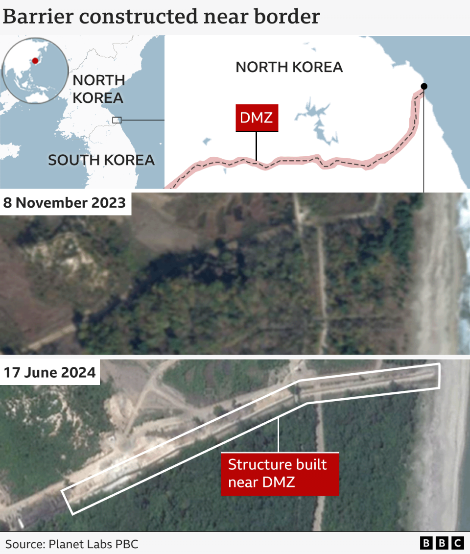
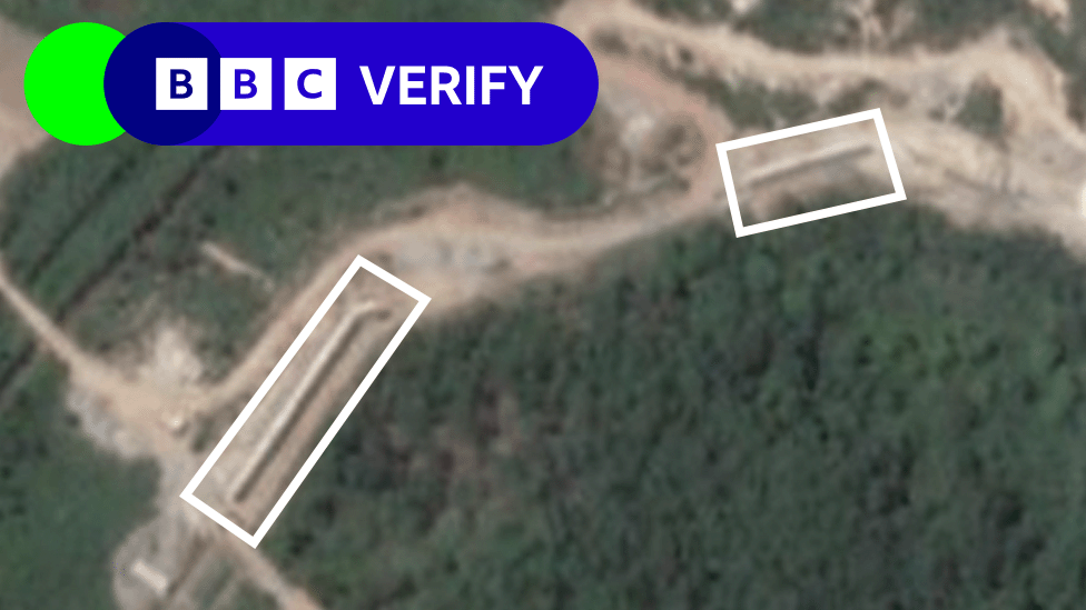
BBC Verify commissioned high-resolution satellite imagery of a 7km stretch of the border as part of a project to look at changes North Korea was making to the area.
These images appear to show at least three sections where barriers have been erected near the DMZ, covering a total of about 1km close to the eastern end of the border.
It’s possible that there has been further barrier construction along other stretches of the border.
The exact date construction began is unclear due to a lack of previous high-resolution imagery in the area. However, these structures were not visible in an image captured in November 2023.
“My personal assessment is that this is the first time they've ever built a barrier in the sense of separating places from each other,” Dr Uk Yang, a military and defence expert at Seoul’s Asan Institute for Policy Studies told the BBC.
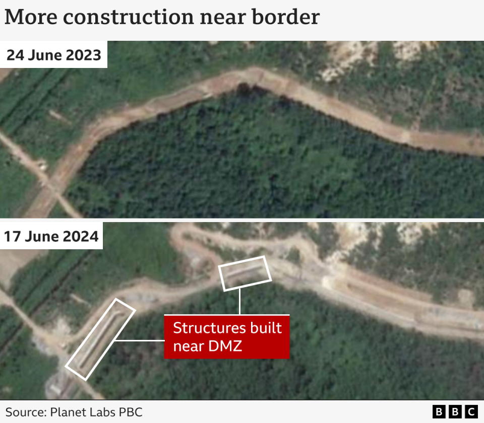
“Back in the 1990s, North Korea had set up the anti-tank walls to deter the advance of tanks in case war broke out. But recently, North Korea has been setting up walls 2-3m high, and they don't look like the anti-tank walls,” Dr Yang says.
“The shape of the walls suggests that they are not just obstacles [for tanks], but are intended to divide an area,” adds Dr Yang, who reviewed the satellite images.
There is also evidence of land clearance within the North Korean side of the DMZ.
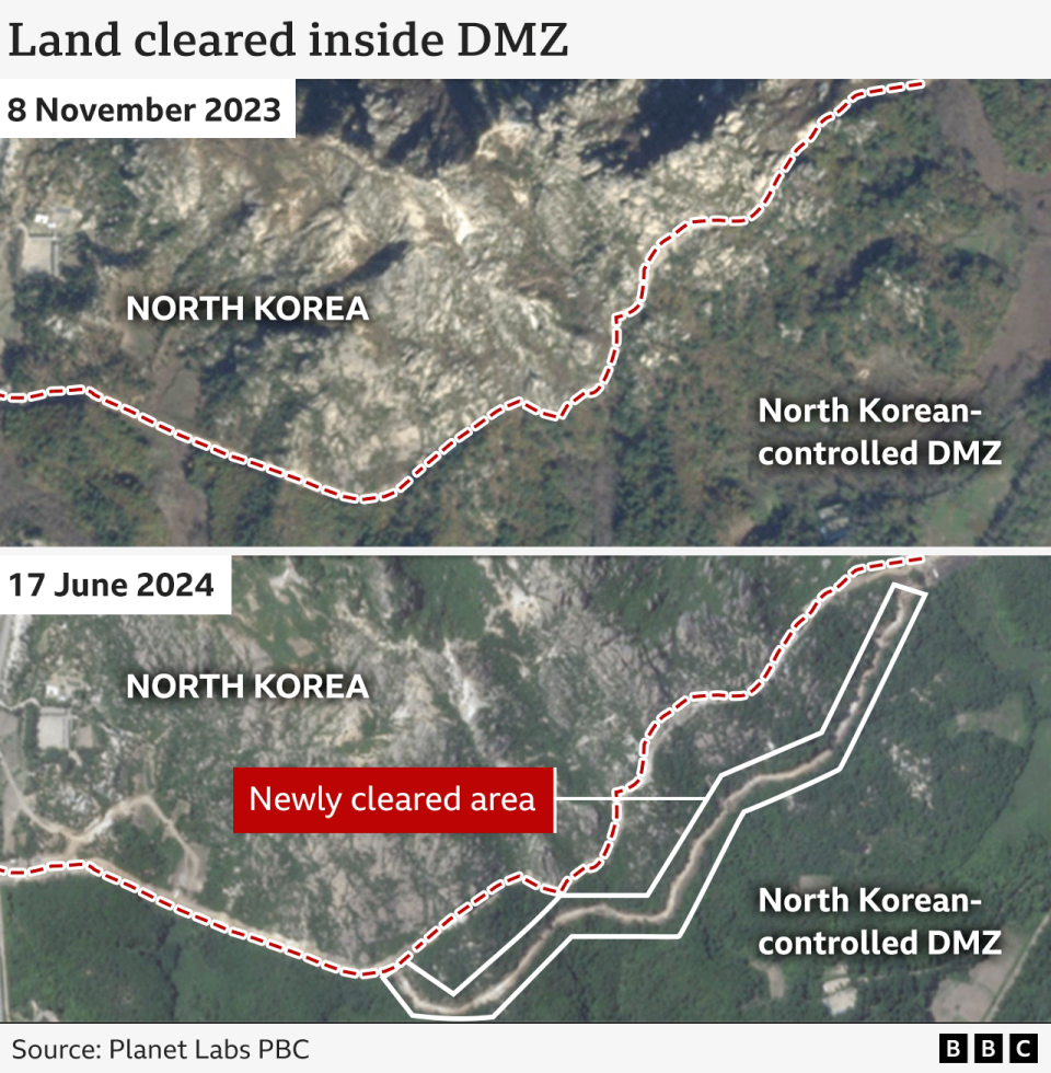
The latest satellite imagery of the eastern end of the boundary shows what appears to be a newly created access road.
In drawing the precise northern boundary of the DMZ in the map above, we have adopted the BBC’s research on border mapping. This is because there are slight variations in the available maps of the boundary. However, all the versions we’ve located show the land clearance taking place within the DMZ.
An official from South Korea’s Joint Chiefs of Staff (JCS) said in a recent briefing that the military had identified ongoing activity related to the “reinforcement of tactical roads, the laying of mines and the clearing of wasteland”.
There have been previous reports of land being cleared at several other locations inside the North Korean-controlled side of the DMZ.
“The land clearing could be intended for both military and non-military aspects”, says Prof Kil Joo Ban of the Ilmin International Relations Institute, Korea University.
"It allows observatory posts to be easily established," he says "for North Korea to monitor military activities in South Korea" and to spot "defectors who attempt to cross the border to South Korea."
“It is unusual to build structures in the DMZ and may be a violation of the armistice without prior consultation,” according to Prof Victor Cha, the senior vice president for Asia and Korea at at the Centre for Strategic and International Studies.
The Korean War ended in 1953 with an armistice, in which both sides pledged not to "execute any hostile act within, from, or against the demilitarised zone”. But there was no final peace settlement.
While reunification has seemed unlikely for years, this had always been the stated goal of North Korean leaders until the start of 2024, when Kim Jong Un announced that his country would no longer pursue that ambition.
Some experts called the remarks “unprecedented” and saw a significant policy change when Mr Kim labelled South Korea as a "principal enemy" at the beginning of this year.
Since then, the North has also started to remove symbols representing the unity of the two countries - such as demolishing monuments and erasing references to reunification on government websites.
“North Korea doesn’t really need more barriers to prevent a strike from the South but by erecting these border barriers, the North is signalling that it doesn’t seek reunification,” says Dr Ramon Pacheco Pardo, head of European and International Studies at Kings College London.
Some experts also say this aligns with Mr Kim’s broader actions.
“North Korea is not even pretending to want to negotiate with the United States or South Korea, and has rebuffed the recent attempts by Japan to engage in talks,” says Dr Edward Howell, Korean Peninsula researcher at Oxford.
“With North Korea’s warming relations with Russia, we should not be surprised if inter-Korean provocations increase this year.”

What claims do you want BBC Verify to investigate?

